
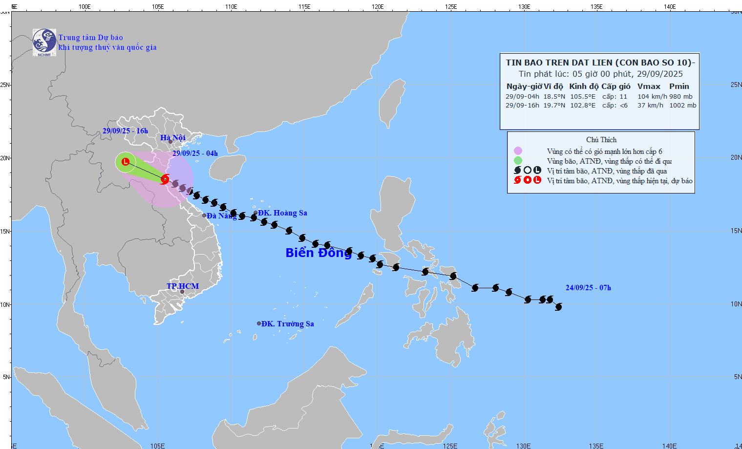
According to the National Center for Hydro-Meteorological Forecasting, at 5:00 a.m. on September 29, the center of the storm was located at about 18.6 degrees North latitude; 105.4 degrees East longitude, on the mainland of Nghe An - Ha Tinh . The strongest wind speed is level 9-10 (75-102 km/h), gusting to level 12. Forecast: In the next 3 hours, the storm will move in the West Northwest direction, at a speed of about 20-25 km/h.
 |
Due to the impact of storm No. 10, the stations recorded:
- Co To ( Quang Ninh ): strong wind level 7, gust level 9
- Bach Long Vi ( Hai Phong ): strong wind level 8, gust level 9
- Hon Ngu ( Nghe An ): strong wind level 9, gust level 13, storm surge 1.6m
- Con Co ( Quang Tri ): strong wind level 10, gust level 11
- Dien Chau (Nghe An): strong wind level 11, gust level 13
- Hoanh Son (Ha Tinh): strong wind level 11, gust level 14
- Ky Anh (Ha Tinh): strong wind level 10, gust level 12
Forecast until 4pm on September 29, the storm will move in the West Northwest direction, 20-25km/h, go deep inland, gradually weaken into a tropical depression, then a low pressure area, located at about 19.7 degrees North latitude - 102.8 degrees East longitude, in the Upper Laos region. Intensity below level 6.
Danger zone is around latitude 17.0N-20.0N; west of longitude 108.0E.
Level 3 natural disaster risk in the sea area from Thanh Hoa to Quang Tri (including Hon Ngu island, Con Co special zone); Northern Bac Bo Gulf (including Bach Long Vi special zone, Van Don, Co To, Cat Hai and Hon Dau island).
Forecast of storm impact:
Sea area from Thanh Hoa to Quang Tri (Hon Ngu, Con Co): level 6-8, near the storm center level 9-10, gust level 12; waves 3.0-5.0m, very rough sea. Northern Gulf of Tonkin (Bach Long Vi, Van Don, Co To, Cat Hai, Hon Dau): level 6-7, gust level 8-9; waves 2.0-4.0m, rough sea
Coastal areas and islands of provinces from Hai Phong to Nghe An have storm surges of 0.5-1.5m high. Warning: Risk of flooding in low-lying coastal areas and river mouths due to storm surges combined with high tides and large waves on the morning of September 29.
On land in Nghe An - Ha Tinh: level 7-9, near the storm center level 10-11, gust level 13. Quang Ninh - Thanh Hoa: level 6-7, gust level 8-9.
On September 29-30, the Northern Delta, Phu Tho, Southern Son La - Lao Cai, Thanh Hoa - Ha Tinh will have heavy rain, with total rainfall of 150-250mm, in some places >400mm. Other places in the North & Northern Quang Tri: 100-200mm, in some places >300mm. Warning of heavy rain (>200mm/3h).
According to PV/VOV.VN
Source: https://baovinhlong.com.vn/thoi-su/202509/bao-so-10-dang-tren-dat-lien-nghe-an-ha-tinh-cuong-do-cap-9-10-giat-cap-12-803039b/
![[Photo] General Secretary To Lam, Secretary of the Central Military Commission attends the 12th Party Congress of the Army](https://vphoto.vietnam.vn/thumb/1200x675/vietnam/resource/IMAGE/2025/9/30/9b63aaa37ddb472ead84e3870a8ae825)
![[Photo] Panorama of the cable-stayed bridge, the final bottleneck of the Ben Luc-Long Thanh expressway](https://vphoto.vietnam.vn/thumb/1200x675/vietnam/resource/IMAGE/2025/9/30/391fdf21025541d6b2f092e49a17243f)
![[Photo] The 1st Congress of Phu Tho Provincial Party Committee, term 2025-2030](https://vphoto.vietnam.vn/thumb/1200x675/vietnam/resource/IMAGE/2025/9/30/1507da06216649bba8a1ce6251816820)
![[Photo] President Luong Cuong receives President of the Cuban National Assembly Esteban Lazo Hernandez](https://vphoto.vietnam.vn/thumb/1200x675/vietnam/resource/IMAGE/2025/9/30/4d38932911c24f6ea1936252bd5427fa)

![[Photo] Solemn opening of the 12th Military Party Congress for the 2025-2030 term](https://vphoto.vietnam.vn/thumb/1200x675/vietnam/resource/IMAGE/2025/9/30/2cd383b3130d41a1a4b5ace0d5eb989d)


Comment (0)