
The National Center for Hydro-Meteorological Forecasting said that at 11:00 a.m. today, the center of storm No. 10 was located at about 17.0 degrees north latitude and 108.8 degrees east longitude, about 125 km east-northeast of Hue City, and about 240 km south-southeast of northern Quang Tri .

Storm No. 10 is slowing down before making landfall from Thanh Hoa to Quang Tri. PHOTO: WINDY
Near the center of the storm, the strongest wind is level 12, equivalent to a speed of 118 - 133 km/h, gusting to level 15. It is forecasted that within 3 hours, storm No. 10 will move northwest, at a speed of about 25 km/h.
Compared to early this morning, storm No. 10 has slowed down before making landfall. It is forecasted that at around 4 p.m. today, the center of storm No. 10 will be in the sea area of Nghe An - Quang Tri, with strong winds of level 12 - 13, gusting to level 16.
Due to the influence of storm No. 10, it is forecasted that from noon today, September 28, the wind on the mainland of Thanh Hoa - northern Quang Tri will gradually increase to level 6 - 7, then increase to level 8 - 9. The area near the center of the storm will have strong winds of level 10 - 12, gusts of 14 and the strongest wind will last from the evening until the end of tonight, September 28. It is forecasted that after making landfall, storm No. 10 will be active on land for 6 - 8 hours.
The National Center for Hydro-Meteorological Forecasting warns in detail that each area will have strong winds due to the influence of storm No. 10.
Specifically in Quang Tri province, the coastal area in the south of Quang Tri province (the old Quang Tri province) will have strong winds of level 6 - 7. The strong wind period is forecast from noon to tonight. The northern area of the province (the old Quang Binh province) will have strong winds of level 8, the area near the storm center (the area bordering Deo Ngang) will have strong winds of level 9 - 11, gusting to level 14. The strong wind period is forecast to last from 5:00 p.m. to 11:00 p.m.
In Ha Tinh and Nghe An provinces from the afternoon of September 28, there will be strong winds of level 6-7, from the evening and night there will be strong winds of level 8-9, coastal areas will have strong winds of level 10-12, gusting to level 14. The forecast is that the strong winds will last from 7-11pm, in inland districts strong winds will last from 8pm on September 28 to 2am on September 29.
Thanh Hoa province will have strong winds of level 6-7 from this afternoon, the southern part of Thanh Hoa province will have strong storm winds of level 8-10, gusts of level 13, strong winds are forecasted to last from 7-11pm today, September 28.
Storm surge No. 10 is 1-1.5 m high in Thanh Hoa and Nghe An.
According to the National Center for Hydro-Meteorological Forecasting, coastal areas and islands from Hung Yen to Ha Tinh will have water levels rising due to storm No. 10 from 0.5 to 1.5 meters, especially in Thanh Hoa and Nghe An where it will be 1 to 1.5 meters high; there is a high risk of flooding on the morning of September 29 in low-lying areas, coastal roads, and river mouths due to rising sea levels, waves, and rain during the storm.
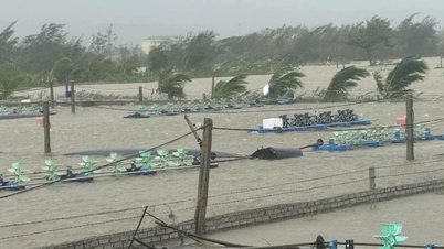
The weather at sea and in coastal areas during storm No. 10 is extremely dangerous, unsafe for any vehicles or structures operating in the danger zone such as: cruise ships, passenger ships, transport ships, cages, rafts, aquaculture areas, dykes, embankments, coastal routes. Vehicles are highly likely to capsize, be destroyed; be flooded due to strong winds, big waves and rising sea levels.
It is forecasted that from September 28 to 30, the northern provinces and the area from Thanh Hoa to Da Nang City will have moderate rain, heavy rain, and in some places very heavy rain, with total rainfall ranging from 100 - 300 mm, with heavy rain in some places exceeding 450 mm. In particular, the Northern Delta, Phu Tho, the southern part of Son La and Lao Cai provinces from Thanh Hoa to the north of Quang Tri will have heavy to very heavy rain due to the influence of storm No. 10 (storm Bualoi). The total rainfall is forecast to range from 200 - 400 mm, in some places exceeding 600 mm./.
According to Thanh Nien Newspaper
Source: https://thanhnien.vn/bao-so-10-di-cham-lai-canh-bao-khu-vuc-thoi-gian-gio-bao-manh-nhat-185250928121117554.htm
Source: https://baolongan.vn/bao-so-10-di-cham-lai-canh-bao-khu-vuc-thoi-gian-gio-bao-manh-nhat-a203343.html

![[Photo] Many streets in Hanoi were flooded due to the effects of storm Bualoi](https://vphoto.vietnam.vn/thumb/1200x675/vietnam/resource/IMAGE/2025/9/29/18b658aa0fa2495c927ade4bbe0096df)
![[Photo] National Assembly Chairman Tran Thanh Man chairs the 8th Conference of full-time National Assembly deputies](https://vphoto.vietnam.vn/thumb/1200x675/vietnam/resource/IMAGE/2025/9/29/2c21459bc38d44ffaacd679ab9a0477c)


![[Photo] General Secretary To Lam chairs the meeting of the Central Steering Committee on preventing and combating corruption, waste and negativity](https://vphoto.vietnam.vn/thumb/1200x675/vietnam/resource/IMAGE/2025/9/29/fb2a8712315d4213a16322588c57b975)


Comment (0)