
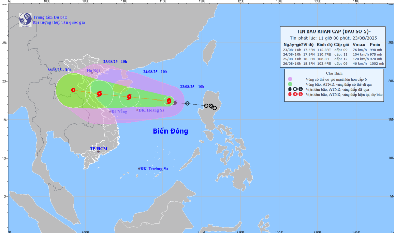
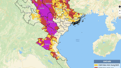
Forecast map of the trajectory and intensity of storm No. 5 issued at 11:00 a.m. on August 23, 2025. Photo: nchmf
At 10:00 a.m. on August 23, the center of the storm was at about 17.4 degrees North latitude; 115.8 degrees East longitude, about 380 km East Northeast of Hoang Sa special zone. The strongest wind near the center of the storm was level 8-9 (62-88 km/h), gusting to level 11; moving in the West Northwest direction at a speed of about 25 km/h.
The storm is forecast to move very quickly and increase in intensity very strongly. From tomorrow night (August 24), it will cause rain and strong winds for the North Central coast, focusing on Thanh Hoa to Quang Tri .
It is forecasted that by 10:00 a.m. on August 24, storm No. 5 will move in the West Northwest direction, at a speed of about 20-25 km/h and continue to strengthen, with gusts of level 10 and 11, and near the storm center gusts of level 13 and 15.
At 10:00 a.m. on August 25, storm No. 5 moved in the West-Northwest direction at a speed of about 20km/h, the center of the storm was at 18.3N-106.8E; in the sea area from Thanh Hoa to Hue, wind gusts were at level 11-12, up to level 15.
At 10:00 a.m. on August 26, storm No. 5 moved in the West Northwest direction at a speed of about 15km/h and gradually weakened into a tropical depression over the mainland of Central Laos.
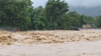
The impact of the storm caused strong waves and strong winds.
At sea:
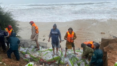
- In the North East Sea (including Hoang Sa special zone), there will be strong winds of level 8-9, near the storm center level 10-11, gusts of level 14, waves 4.0-6.0m high, rough seas. From noon and afternoon of August 24, the sea area from Thanh Hoa to Hue (including Con Co and Hon Ngu special zones) will have winds gradually increasing to level 6-8, then increasing to level 9-10, near the storm center level 11-12, gusts of level 15; waves 4.0-6.0m high, near the center 6.0-8.0m; rough seas.
From the afternoon of August 24, the sea area in the northern Gulf of Tonkin (including Bach Long Vi special zone) will have winds gradually increasing to level 6-7, gusting to level 9, waves 2.0-4.0m high, and rough seas.
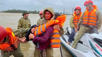
Storm surge and flood warning for coastal areas: The coastal area of Thanh Hoa - Quang Tri has storm surge from 0.5-1.0m high. Water level in Sam Son (Thanh Hoa) is 3.2-3.6m high, in Hon Ngu (Nghe An) is 3.3-3.7m high, in Vung Ang (Ha Tinh) is 3.1-3.4m high and in Cua Gianh (Quang Tri) is 1.7-2.0m high. There is a high risk of flooding in low-lying coastal areas, river mouths, and islands from Nghe An to Northern Quang Tri.
The weather at sea and in coastal areas during the storm is extremely dangerous and unsafe for any vehicle or structure operating in the danger zone such as: cruise ships, passenger ships, transport ships, cages, rafts, aquaculture areas, dykes, embankments, coastal routes. Vehicles are highly likely to capsize, be destroyed; be flooded due to strong winds, big waves and rising sea levels.
On land:
- From the night of August 24, on land from Thanh Hoa to Quang Tri, winds will gradually increase to level 7-9, near the storm center level 10-12, gusting to level 13-15.
From the night of August 24 to the end of August 26, in the Northern Delta, South Phu Tho and from Thanh Hoa to Hue, there is a possibility of widespread heavy rain with common rainfall of 100-150mm, locally over 250mm; in the Thanh Hoa to Quang Tri area, there will be heavy to very heavy rain with common rainfall of 150-300mm, locally over 600mm. Warning of the risk of heavy rain (>200mm/3h).
-From August 25-26: In the capital Hanoi and Da Nang city, there will be moderate rain, heavy rain and thunderstorms; in the Ho Chi Minh city area, there will be rain, showers and thunderstorms in the late afternoon and evening; During thunderstorms, be on guard against the risk of tornadoes and strong gusts of wind.
-From August 25-27, the Upper and Central Laos regions are likely to experience heavy rain with common rainfall of 100-250mm, and in some places in the Central Laos region, over 500mm.
See detailed updates on storm number 5 here.
LP
Source: https://baothanhhoa.vn/bao-so-5-lien-tuc-tang-cap-huong-thang-ve-cac-tinh-tu-thanh-hoa-quang-tri-259145.htm
![[Photo] Many streets in Hanoi were flooded due to the effects of storm Bualoi](https://vphoto.vietnam.vn/thumb/1200x675/vietnam/resource/IMAGE/2025/9/29/18b658aa0fa2495c927ade4bbe0096df)
![[Photo] General Secretary To Lam attends the ceremony to celebrate the 80th anniversary of the post and telecommunications sector and the 66th anniversary of the science and technology sector.](https://vphoto.vietnam.vn/thumb/1200x675/vietnam/resource/IMAGE/2025/9/29/8e86b39b8fe44121a2b14a031f4cef46)
![[Photo] General Secretary To Lam receives US Ambassador to Vietnam Marc Knapper](https://vphoto.vietnam.vn/thumb/1200x675/vietnam/resource/IMAGE/2025/9/29/c8fd0761aa184da7814aee57d87c49b3)
![[Photo] National Assembly Chairman Tran Thanh Man chairs the 8th Conference of full-time National Assembly deputies](https://vphoto.vietnam.vn/thumb/1200x675/vietnam/resource/IMAGE/2025/9/29/2c21459bc38d44ffaacd679ab9a0477c)


Comment (0)