
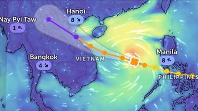
On the morning of September 23, the National Center for Hydro-Meteorological Forecasting said that at 6:00 a.m., the center of super typhoon Ragasa was at about 19.8 degrees North latitude - 118.5 degrees East longitude (Northern East Sea area), about 840km east of Leizhou Peninsula (China). The strongest wind near the center of the storm is still at the maximum level - level 17 (202-221km/h), gusting above level 17. In the next 3 hours, the storm will move in the West Northwest direction at a speed of about 20km/h.

The National Center for Hydro-Meteorological Forecasting said that in the early morning of September 24, the storm's center will be about 450km east of the Leizhou Peninsula. The storm has slightly decreased in intensity but will still maintain level 16-17, gusting above level 17. The North East Sea area is at level 4 natural disaster risk warning level.
By the morning of September 25, the storm had made landfall in southern Guangdong province (China), its intensity had decreased to level 12, gusting to level 15. The northern East Sea remained at level 4 risk warning, while the northern Gulf of Tonkin was raised to level 3 risk warning.
On September 25, the storm continued to weaken, changed direction to West Southwest and entered the Northern mainland (focusing on the area from Quang Ninh to Ninh Binh ). After entering the mainland, by the morning of September 26, the storm reduced its intensity to level 6, gusting to level 8, becoming a tropical depression.

The National Center for Hydro-Meteorological Forecasting warns: From early morning on September 25, coastal areas from Quang Ninh to Thanh Hoa will have winds gradually increasing to level 6-7, then increasing to level 8, near the storm center level 9-10, gusting to level 12. At the same time, inland areas in the Northeast will have strong winds of level 6-7, gusting to level 8-9.
From the night of September 24 to September 26, in the Northern region, Thanh Hoa and Nghe An will have heavy to very heavy rain with common rainfall of 100-250mm, locally over 400mm. At the same time, localities also need to be on guard against tornadoes due to the influence of the wide storm circulation, both before and during the storm's landfall.
 according to the US meteorological agency (updated at 7:00 am this morning)")
Why did the super typhoon weaken?
According to meteorological experts, the cause is the friction of the storm with mainland China and dry air from the cold continental air mass that will cause the storm to lose energy quickly.
The time when the storm was at its strongest - reaching level 17 (202-221km/h), gusting above level 17 was from the night of September 22 to September 23. This is the first time in Vietnam's meteorological history that a storm had a level 17 wind level, the highest level in the storm scale that Vietnam applies.
Regarding the storm's trajectory, there is currently almost no dispersion between forecast models. Accordingly, 8 storm forecasting centers in the region (including Vietnam, the United States, Japan, China, South Korea, the Philippines, Taiwan and Hong Kong) all predict that the storm will enter the south of Guangdong, move along the coast and then enter the north of our country.
, storm No. 9 (Ragasa) will lose its intensity. Source: Z.E")
Currently, all four prestigious international meteorological agencies have commented that from the evening of September 24, when the storm enters the Leizhou Peninsula (China), it will decrease by 3-5 levels. Specifically, US stations forecast that the storm will still be at level 13, Japan believes that the storm will still be at level 12, Hong Kong (China) believes that the storm will decrease to level 14...
According to these forecasting centers, the closer the storm gets to Vietnam’s mainland, the more it will weaken. Of these, China is said to have weakened the most (only level 9 before entering Vietnam).
According to meteorological experts, in the next few hours, if the forecasted direction of movement remains, international and Vietnamese storm forecasting centers will continue to gradually adjust the storm's intensity.
Source: https://www.sggp.org.vn/bao-so-9-ragasa-se-giam-cap-khi-tien-gan-dat-lien-viet-nam-post814263.html
![[Photo] Solemn opening of the 12th Military Party Congress for the 2025-2030 term](https://vphoto.vietnam.vn/thumb/1200x675/vietnam/resource/IMAGE/2025/9/30/2cd383b3130d41a1a4b5ace0d5eb989d)

![[Photo] President Luong Cuong receives President of the Cuban National Assembly Esteban Lazo Hernandez](https://vphoto.vietnam.vn/thumb/1200x675/vietnam/resource/IMAGE/2025/9/30/4d38932911c24f6ea1936252bd5427fa)
![[Photo] The 1st Congress of Phu Tho Provincial Party Committee, term 2025-2030](https://vphoto.vietnam.vn/thumb/1200x675/vietnam/resource/IMAGE/2025/9/30/1507da06216649bba8a1ce6251816820)
![[Photo] General Secretary To Lam, Secretary of the Central Military Commission attends the 12th Party Congress of the Army](https://vphoto.vietnam.vn/thumb/1200x675/vietnam/resource/IMAGE/2025/9/30/9b63aaa37ddb472ead84e3870a8ae825)
![[Photo] Panorama of the cable-stayed bridge, the final bottleneck of the Ben Luc-Long Thanh expressway](https://vphoto.vietnam.vn/thumb/1200x675/vietnam/resource/IMAGE/2025/9/30/391fdf21025541d6b2f092e49a17243f)


Comment (0)