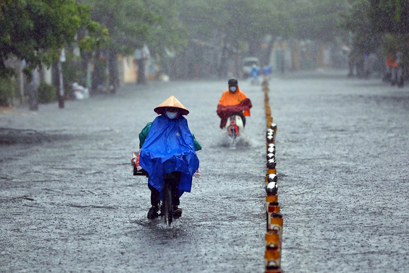
Heavy rain across the North and Central regions, storm No. 10 moves quickly in the East Sea
Heavy to very heavy rain is forecast to occur in all provinces and cities in the North and Central regions today, locally over 400mm. Storm Bualoi has entered the East Sea, becoming storm number 10 with winds of level 11-12 and is still moving at a very fast speed.
Báo Công an Nhân dân•26/09/2025
According to the National Center for Hydro-Meteorological Forecasting, the weather in the whole country on Saturday (September 27), Hanoi capital is cloudy, with moderate rain, heavy rain and thunderstorms in the morning, and very heavy rain in some places; scattered showers and thunderstorms later. East wind level 2-3. During thunderstorms, there is a possibility of tornadoes, lightning and strong gusts of wind. Lowest temperature 24-26 degrees. Highest temperature 27-29 degrees.
Today the weather forecast is heavy rain all over the country.
The Northwest region is cloudy with scattered showers and thunderstorms, some places have heavy rain; in the South of Phu Tho, there will be moderate rain, heavy rain and thunderstorms, some places have very heavy rain. Light wind. During thunderstorms, there is a possibility of tornadoes, lightning and strong gusts of wind. The lowest temperature is 22-25 degrees, some places below 21 degrees. The highest temperature is 26-29 degrees.
Northeast region is cloudy, with scattered showers and thunderstorms in the morning, with some places experiencing heavy to very heavy rain; later scattered showers and thunderstorms, with some places experiencing heavy rain. East to northeast wind level 2-3. During thunderstorms, there is a possibility of tornadoes, lightning, and strong gusts of wind. Lowest temperature 23-26 degrees. Highest temperature 26-29 degrees.
From Thanh Hoa to Hue, it is cloudy with rain, moderate rain and scattered thunderstorms, locally heavy to very heavy rain; in the North, in the morning, there is moderate rain, heavy rain and scattered thunderstorms, locally very heavy rain. North to northwest wind level 2-3. During thunderstorms, there is a possibility of tornadoes, lightning, hail and strong gusts of wind. Lowest temperature 23-26 degrees. Highest temperature 27-30 degrees.
The South Central Coast is cloudy, with rain, moderate rain and scattered thunderstorms in the North, locally heavy to very heavy rain; scattered showers and thunderstorms in the South, locally heavy rain. West to southwest wind level 2-3. During thunderstorms, there is a possibility of tornadoes, lightning, hail and strong gusts of wind. Lowest temperature 24-27 degrees. Highest temperature 29-32 degrees.
Central Highlands cloudy, scattered showers and thunderstorms, locally heavy rain (rain concentrated in the afternoon and night). Southwest wind level 2-3. During thunderstorms, there is a possibility of tornadoes, lightning, hail and strong gusts of wind. Lowest temperature 19-22 degrees. Highest temperature 25-28 degrees.
The South is cloudy with scattered showers and thunderstorms, with some heavy rain in some places (rain is concentrated in the afternoon and evening). Southwest wind level 2-3. Lowest temperature 24-27 degrees. Highest temperature 30-33 degrees.
Ho Chi Minh City is cloudy with scattered showers and thunderstorms; in the late afternoon and evening there will be scattered showers and thunderstorms, with some heavy rain in some places. Southwest wind level 2-3. Lowest temperature 24-26 degrees. Highest temperature 31-33 degrees.
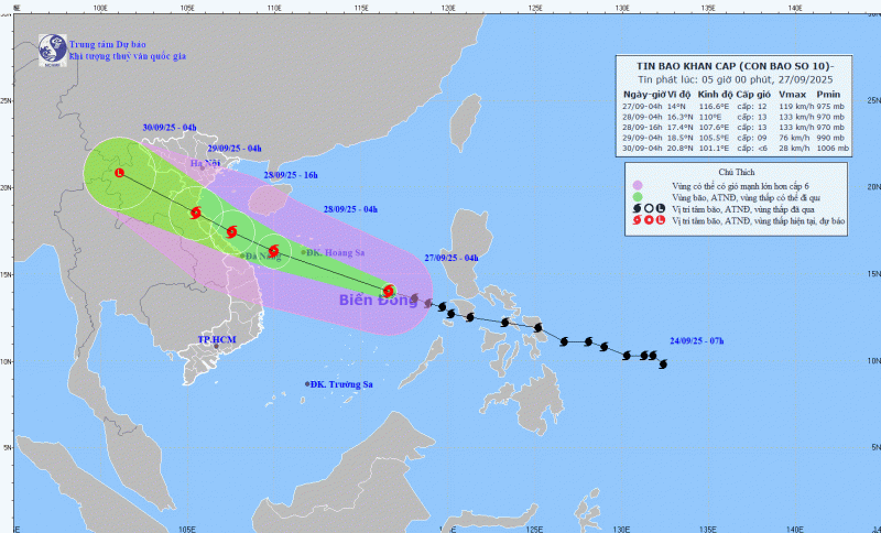
Update on storm No. 10 (BUALOI), at 4:00 a.m. on September 27, the center of the storm was at about 14.0 degrees North latitude; 116.6 degrees East longitude, about 580km East Southeast of Hoang Sa special zone. The strongest wind near the center of the storm is level 11-12 (103-133km/h), gusting to level 15. Moving in the West Northwest direction at a speed of 35-40km/h.
This is a very fast moving storm (nearly twice the average speed), with strong storm intensity and wide range of influence, which can cause combined impacts of many types of natural disasters such as strong winds, heavy rains, floods, flash floods, landslides and coastal flooding.
In the next 24 hours, the storm will move in the West-Northwest direction at a speed of 30-35km/h and is likely to strengthen. At 4am on September 28, the center of the storm will be in the sea west of Hoang Sa special zone, about 180km east of Da Nang city with intensity of level 12-13, gusting to level 16. Disaster risk warning at level 3 for affected areas in the North and Central East Sea (including Hoang Sa special zone); sea areas from Ha Tinh to Quang Ngai.
Warning, the weather at sea and in coastal areas during the storm is extremely dangerous, unsafe for any vehicle or structure operating in the danger zone such as: cruise ships, passenger ships, transport ships, cages, rafts, aquaculture areas, dykes, embankments, coastal routes. Vehicles are highly likely to capsize, be destroyed; be flooded due to strong winds, big waves and rising sea levels.


![[Photo] Prime Minister Pham Minh Chinh attends the groundbreaking ceremony of two key projects in Hai Phong city](https://vphoto.vietnam.vn/thumb/1200x675/vietnam/resource/IMAGE/2025/9/27/6adba56d5d94403093a074ac6496ec9d)


![[Live] Vietnam Tourism Awards Ceremony 2025](https://vphoto.vietnam.vn/thumb/402x226/vietnam/resource/IMAGE/2025/9/27/001400e8ad9a46e9a3651a828cc6834d)


Comment (0)