
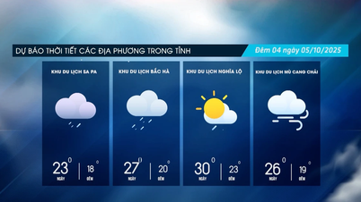
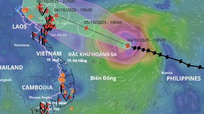
According to the National Center for Hydro-Meteorological Forecasting, as of 1 p.m. this afternoon (September 7), the center of storm No. 7 (Tapah) was located in the northern sea area of the North East Sea. The strongest wind near the center of the storm was level 9 (75-88 km/h), gusting to level 11. Moving northwest at about 10 km/h.
In the next 12 hours, the storm will continue to move northwest, increasing its speed to 15-20km/h, and continue to strengthen. By 1am tomorrow (September 8), the center of the storm will be about 220km southwest of Macau (China); its intensity will reach level 10, gusting to level 13, the strongest of this storm.

Forecast, in the next 12 hours, the storm will maintain its direction and speed of movement. By 1:00 p.m. on September 8, the center of the storm will be located on the mainland south of Guangdong province (China), the intensity will decrease to level 8, gusting to level 10.
In the next 24 hours, the storm moved to the West Northwest, 15-20km/h, weakening into a low pressure area on the mainland of Guangxi province (China).
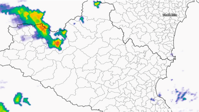
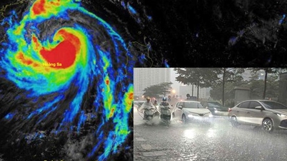
Notably, although storm No. 7 will not make landfall in our country, areas on the far edge of the storm's circulation such as the Gulf of Tonkin and some northern provinces may experience thunderstorms, tornadoes, heavy rain and strong gusts of wind; especially causing a heavy rainstorm in the North.
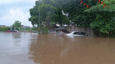
In the North, there will be scattered showers and thunderstorms, with some places experiencing heavy to very heavy rain; in the mountainous and midland areas, there will be moderate rain, heavy rain and thunderstorms, with some places experiencing very heavy rain. Specifically, from September 9 to the night of September 10, the average rainfall will be 70-150mm, with some places experiencing over 300mm.
Warning of the risk of heavy rain (>100mm/3h). During thunderstorms, there is a possibility of tornadoes, lightning, hail and strong gusts of wind. Heavy rain can cause flooding in low-lying areas, urban and industrial areas; flash floods on small rivers and streams; landslides on steep slopes.
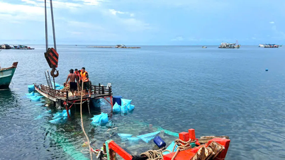
In addition, due to the impact of the storm, the northern sea area of the North East Sea has strong winds of level 7-8, the area near the storm center has strong winds of level 9-10, gusts of level 13; waves are 3-5m high, and the sea is very rough. Ships operating in the above-mentioned dangerous areas are likely to be affected by storms, whirlwinds, strong winds, and large waves.
Source: https://baolaocai.vn/ria-xa-hoan-luu-bao-so-7-gay-mua-lon-cho-mien-bac-nhu-the-nao-post881523.html
![[Photo] General Secretary To Lam attends the 8th Congress of the Central Public Security Party Committee](https://vphoto.vietnam.vn/thumb/1200x675/vietnam/resource/IMAGE/2025/10/4/79fadf490f674dc483794f2d955f6045)
![[Photo] Solemn opening of the 8th Congress of the Central Public Security Party Committee, term 2025-2030](https://vphoto.vietnam.vn/thumb/1200x675/vietnam/resource/IMAGE/2025/10/4/f3b00fb779f44979809441a4dac5c7df)


![[Photo] Bustling Mid-Autumn Festival at the Museum of Ethnology](https://vphoto.vietnam.vn/thumb/1200x675/vietnam/resource/IMAGE/2025/10/4/da8d5927734d4ca58e3eced14bc435a3)


![[VIDEO] Summary of Petrovietnam's 50th Anniversary Ceremony](https://vphoto.vietnam.vn/thumb/402x226/vietnam/resource/IMAGE/2025/10/4/abe133bdb8114793a16d4fe3e5bd0f12)
![[VIDEO] GENERAL SECRETARY TO LAM AWARDS PETROVIETNAM 8 GOLDEN WORDS: "PIONEER - EXCELLENT - SUSTAINABLE - GLOBAL"](https://vphoto.vietnam.vn/thumb/402x226/vietnam/resource/IMAGE/2025/7/23/c2fdb48863e846cfa9fb8e6ea9cf44e7)


Comment (0)