
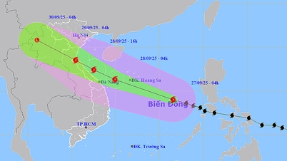
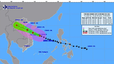
It is forecasted that in the next 24 hours, the tropical depression will likely strengthen. At 1:00 a.m. on September 18, the center of the tropical depression will be at about 19.2 degrees North latitude; 120.3 degrees East longitude, in the sea north of Luzon Island (Philippines), with a level 8 strength, gusting to level 10 and likely to strengthen into a storm. The risk of natural disasters is at level 3 in the northeastern area of the East Sea.
At 1:00 a.m. on September 19, the storm center may be at about 21.2 degrees North latitude; 118.0 degrees East longitude, in the northeastern sea area of the North East Sea, with strong winds of level 8-9, gusting to level 11. In the next 48-72 hours, the storm will move in the West-Northwest direction at a speed of 10-15 km/h, with little change in intensity.
From the night of September 17, the wind in the northeastern part of the East Sea will gradually increase to level 6-7, gusting to level 9. The area near the storm center will have wind level 8, gusting to level 10, waves 2.5-4.5m high, rough seas. There is a high risk for ships operating in the danger zone as they may encounter thunderstorms, tornadoes, strong winds and large waves. During the day and night of September 17, the wind in the central East Sea will be level 5, sometimes level 6, gusting to level 7-8, waves 2-3m high, rough seas.
In addition, on the day and night of September 17, the North, Central and South East Sea (including Hoang Sa and Truong Sa seas), the Gulf of Tonkin, the sea from South Quang Tri to Ca Mau, from Ca Mau to An Giang and the Gulf of Thailand will have scattered showers and thunderstorms; in particular, the northeastern sea of the North East Sea will have storms. Thunderstorms pose a risk of tornadoes, strong gusts of wind of level 6-7 and waves over 2m high.

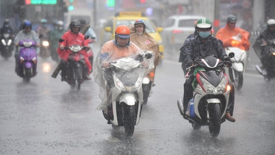
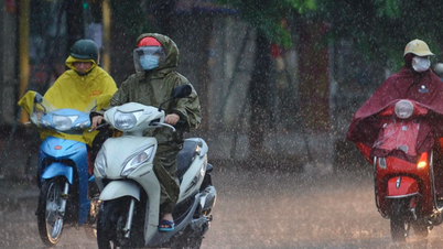
On land, last night and early this morning (September 17), the area from Hue to Khanh Hoa had showers and thunderstorms, with some places experiencing heavy rain. The amount of rain measured from 7 p.m. on September 16 to 3 a.m. on September 17 was over 50mm in some places, such as Quang Dien (Hue) 68.2mm, Ia Kenh (Gia Lai) 88.4mm, Song Hinh ( Dak Lak ) 51.8mm.
It is forecasted that in the afternoon and night of September 17, the area from Hue to Lam Dong and the South will continue to have scattered showers and thunderstorms, with average rainfall of 15-30mm, and locally heavy rain of over 80mm. Rain is likely to appear with high intensity of over 80mm in 3 hours.
Meteorological experts warn that thunderstorms may bring tornadoes, lightning, hail and strong gusts of wind. Mountainous areas should be on guard against flash floods on small rivers and streams, and landslides on steep slopes. Low-lying and urban areas may experience localized flooding when heavy rains occur.
Faced with the complex developments of the tropical depression that is likely to strengthen into a storm, authorities recommend that vessels operating at sea should closely monitor forecast bulletins, proactively avoid and move away from dangerous areas; local authorities and people in coastal and island areas should prepare response plans to minimize damage.
Weather forecast for regions across the country:
Hanoi capital is cloudy, with occasional showers and thunderstorms in the morning and at night, and sunny during the day. Light wind. During thunderstorms, there is a possibility of tornadoes, lightning, and strong gusts of wind. Lowest temperature 26-28 degrees Celsius. Highest temperature 33-35 degrees Celsius.
The Northwestern provinces are cloudy and sunny during the day; showers and thunderstorms in some places in the evening and at night. Light wind. During thunderstorms, there is a possibility of tornadoes, lightning, hail and strong gusts of wind. The lowest temperature is 23-26 degrees Celsius, some places below 22 degrees Celsius. The highest temperature is 31-34 degrees Celsius, some places above 34 degrees Celsius.
The Northeastern region is cloudy, sunny during the day, with scattered showers and thunderstorms at night; in the plains and coastal areas, there will be scattered showers and thunderstorms in the morning and at night. Light wind. During thunderstorms, there is a possibility of tornadoes, lightning, hail and strong gusts of wind. The lowest temperature is 24-27 degrees Celsius, in mountainous areas, it will be below 23 degrees Celsius. The highest temperature is 32-35 degrees Celsius.
Provinces from Thanh Hoa to Hue have cloudy weather, sunny days, scattered showers and thunderstorms in the afternoon and evening; in Hue city, there will be scattered showers and thunderstorms in the afternoon and evening, with some heavy rain. Light wind. During thunderstorms, there is a possibility of tornadoes, lightning, hail and strong gusts of wind. Lowest temperature 24-27 degrees Celsius. Highest temperature 30-33 degrees Celsius.
The South Central Coast region is cloudy, with scattered showers and thunderstorms in the afternoon and at night, with some heavy rain in some places. Southwest wind level 2-3. During thunderstorms, there is a possibility of tornadoes, lightning, hail and strong gusts of wind. Lowest temperature 24-27 degrees Celsius. Highest temperature 31-34 degrees Celsius.
The Central Highlands is cloudy, with scattered showers and thunderstorms in the afternoon and at night, with some heavy rain in some places. Southwest wind level 2-3. During thunderstorms, there is a possibility of tornadoes, lightning, hail and strong gusts of wind. Lowest temperature 19-22 degrees Celsius. Highest temperature 28-31 degrees Celsius.
The South is cloudy, with scattered showers and thunderstorms in the afternoon and at night, with heavy rain in some places. Southwesterly winds at level 2-3. During thunderstorms, there is a possibility of tornadoes, lightning, hail and strong gusts of wind. Lowest temperature 24-27 degrees Celsius. Highest temperature 30-33 degrees Celsius, with some places above 33 degrees Celsius.
Ho Chi Minh City is cloudy, with scattered showers and thunderstorms in the afternoon and at night, with heavy rain in some places. Southwest wind level 2-3. During thunderstorms, there is a possibility of tornadoes, lightning, hail and strong gusts of wind. Lowest temperature 24-26 degrees Celsius. Highest temperature 31-33 degrees Celsius.
Source: https://baolaocai.vn/thoi-weather-ngay-179-ap-thap-nhiet-doi-co-kha-nang-manh-len-thanh-bao-post882274.html


![[Photo] Soldiers guard the fire and protect the forest](https://vphoto.vietnam.vn/thumb/1200x675/vietnam/resource/IMAGE/2025/9/27/7cab6a2afcf543558a98f4d87e9aaf95)


![[Photo] Prime Minister Pham Minh Chinh attends the 1st Hai Phong City Party Congress](https://vphoto.vietnam.vn/thumb/1200x675/vietnam/resource/IMAGE/2025/9/27/676f179ddf8c4b4c84b4cfc8f28a9550)


Comment (0)