
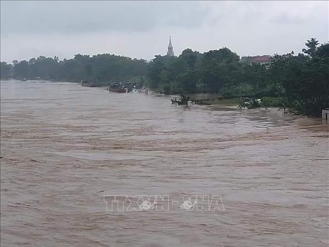
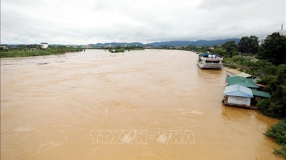
Accordingly, the water level on the main rivers of the Red River - Thai Binh River system, the downstream of most of the main rivers from Thanh Hoa to Hue city is fluctuating and below alarm level 1; the water level on the Chu River (Thanh Hoa) at Cua Dat station is above alarm level 3 (due to local heavy rain and discharge from Cua Dat hydropower plant).
Warning: From September 27 to October 1, floods will appear on rivers in the Northern region, from Thanh Hoa to Hue city. Flood peaks on Thao river (Lao Cai), Hoang Long river (Ninh Binh), Buoi river, Ma river, upstream Chu river (Thanh Hoa), upstream Ca river (Nghe An), Ngan Sau and Ngan Pho rivers (Ha Tinh), Kien Giang river (Quang Tri) and small rivers will rise to alert levels 2-3 and above alert 3; flood peaks at Hoa Binh lake (Phu Tho), Lo river (Tuyen Quang), downstream Chu river, downstream Ca river, La river (Ha Tinh), Gianh river, Thach Han river (Quang Tri), Huong river, Bo river (Hue city) will rise to alert levels 1-2 and above alert 2.
The storm is moving in the West Northwest direction at a speed of 30-35 km/h.
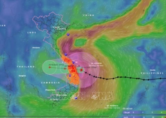
According to the National Center for Hydro-Meteorological Forecasting, at 4:00 p.m. on September 27, the eye of the storm was located at about 15.4 degrees North latitude; 113 degrees East longitude, about 170 km East Southeast of Hoang Sa special zone. The strongest wind near the eye of the storm was level 12 (118-133 km/h), gusting to level 15. Moving in the West Northwest direction at a speed of 30-35 km/h.
This is a very fast moving storm (nearly twice the average speed), with strong storm intensity and wide range of influence, which can cause combined impacts of many types of natural disasters such as strong winds, heavy rains, floods, flash floods, landslides and coastal flooding.
At 4:00 p.m. on September 28, the storm was in the sea area of Quang Tri - Hue city, about 140 km east of Quang Tri with strong winds of 12-13, gusting to level 16; moving in the West Northwest direction at about 30 km/h and likely to strengthen. The affected area is the North and Central East Sea (including Hoang Sa special zone), the sea area from Ha Tinh to Quang Ngai. Natural disaster risk level 3.
Then, at 4:00 a.m. on September 29, the storm on the mainland of Nghe An - North Quang Tri with wind speed of level 9, gusting to level 11; moving in the West Northwest direction at a speed of about 20-25 km/h. The affected areas are the coastal mainland from Nghe An to North Quang Tri with disaster risk level 4; the western sea area of the North East Sea (including Hoang Sa special zone), from Thanh Hoa to Quang Ngai (including Hon Ngu island, Con Co special zone and Ly Son) and the North Gulf of Tonkin (including Bach Long Vy special zone, Van Don, Co To, Cat Hai and Hon Dau island); the mainland area from Ninh Binh to Hue city with risk level 3.
By 4 p.m. on September 29, the storm was in the Upper Laos region with winds below level 6; moving in the West Northwest direction at about 20-25 km/h, weakening into a tropical depression and then a low pressure area. The affected areas are from Thanh Hoa to Quang Tri (including Hon Ngu Island) and the North Gulf of Tonkin (including Bach Long Vy Special Zone, Van Don, Co To, Cat Hai and Hon Dau Island); the mainland area from Ninh Binh to Quang Tri. Disaster risk level 3.
Due to the influence of the storm, the western sea area of the North and Central East Sea (including Hoang Sa special zone) has strong winds of level 8-9, the area near the storm's eye has winds of level 10-13, gusts of level 16, waves of 6-8m high, the area near the storm's eye has waves of 8-10m, and the sea is very rough.
The sea area from Thanh Hoa to Quang Ngai (including Hon Ngu island, Con Co special zone and Ly Son) has strong winds gradually increasing to level 6-7, gusting to level 8-9, waves 3-5m high, rough seas. From early morning on September 28, the wind increased to level 8-9, the area near the storm center has level 10-13, gusting to level 16, waves 5-7m high, rough seas (extremely destructive, extremely strong waves. Sinking large tonnage ships).
From early morning on September 28, in the Northern Gulf of Tonkin (including Bach Long Vi, Van Don, Co To, Cat Hai and Hon Dau islands), the wind gradually increased to level 6-7, then increased to level 8-9 (very rough seas, very dangerous for boats), gusting to level 11, waves 3-5m high, very rough seas.
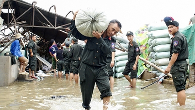
Coastal areas and islands from Ninh Binh to Ha Tinh have storm surges of 0.5-1.5m, especially from South Thanh Hoa to North Ha Tinh where they are 1.0-1.5m high. The risk of flooding of dykes, coastal roads, and river mouths due to storm surges and waves is very high on the evening and night of September 28.
Warning: The weather at sea and in coastal areas during the storm is extremely dangerous, unsafe for any vehicle or structure operating in the danger zone such as: cruise ships, passenger ships, transport ships, cages, rafts, aquaculture areas, dykes, coastal road embankments. Vehicles are at high risk of capsize, destruction; flooding due to strong winds, big waves and rising sea levels.
On land: From the afternoon of September 28, on land from Thanh Hoa to Northern Quang Tri, winds gradually increase to level 6-7, then increase to level 8-9, near the storm center, level 10-12 (wind force can knock down trees, houses, electric poles, causing very heavy damage), gusts of level 14; coastal areas from Quang Ninh to Ninh Binh, from Southern Quang Tri to Hue City, winds gradually increase to level 6-7 (trees shake, difficult to go against the wind), gusts of level 8-9.
From the evening of September 27 to September 30, in the North and the area from Thanh Hoa to Quang Ngai, there is a possibility of widespread heavy rain with total rainfall ranging from 100-300mm, locally over 450mm; in the Northern Delta, South Phu Tho and from Thanh Hoa to North Quang Tri, it is common to have rainfall from 200-400mm, locally over 600mm.
Heavy rain in many areas
The National Center for Hydro-Meteorological Forecasting predicts that from the evening of September 27 to September 29, in the area from Thanh Hoa to the North of Quang Tri, there will be heavy to very heavy rain with common rainfall of 200-400mm, locally over 600mm; the area from South Quang Tri to Quang Ngai will have common rainfall of 100-300mm, some places over 400mm.
Warning of risk of heavy rain over 100mm/1h.
From the afternoon of September 28 to September 29, the Northern Delta and Southern Phu Tho will have heavy rain, locally very heavy rain with common rainfall of 150-300mm, locally over 450mm; other areas in the North will have moderate rain, heavy rain with common rainfall of 70-150mm, locally very heavy rain over 250mm.
Warning of risk of heavy rain over 100mm/3h.
On September 27, the area from Thanh Hoa to Quang Ngai had moderate rain, heavy rain, some places had very heavy rain and thunderstorms. The rainfall from 7am to 3pm on September 27 was over 170mm in some places such as: Chau Phong 1 station (Nghe An) 182.6mm, Dong Ha station (Quang Tri) 203mm, Quang Thanh station (Hue city) 179mm, Hoa Khuong station (Da Nang city) 180mm, ...
Weather in different regions on the night of September 27 and September 28
The Northwest region has scattered showers and thunderstorms, some places have heavy rain, in thunderstorms there is a possibility of tornadoes, lightning and strong gusts of wind. The lowest temperature is 22-25 degrees Celsius, some places below 22 degrees Celsius. The highest temperature is 29-32 degrees Celsius, some places above 32 degrees Celsius.
In the Northeast, there will be scattered showers and thunderstorms, with some places having heavy rain; in the southern delta and coastal areas of the North, from the afternoon of July 28, there will be moderate rain, heavy rain and scattered thunderstorms, with some places having very heavy rain. From tomorrow afternoon, the coastal areas of Quang Ninh to Ninh Binh will gradually increase in strength to level 6-7, gusting to level 8-9. During thunderstorms, there is a possibility of tornadoes, lightning and strong gusts. Northeast wind level 2-3; Lowest temperature 23-26 degrees Celsius. Highest temperature 29-32 degrees Celsius, with some places above 32 degrees Celsius.
Hanoi has scattered showers and thunderstorms; from the afternoon of July 28, there will be scattered showers and thunderstorms, locally heavy rain, with the possibility of tornadoes, lightning and strong gusts of wind in thunderstorms. Northeast wind level 2-3. Lowest temperature 24-26 degrees Celsius. Highest temperature 30-32 degrees Celsius.
Provinces and cities from Thanh Hoa to Hue will have heavy to very heavy rain and thunderstorms. North to Northwest wind level 2-3; from the afternoon of September 28, the wind will gradually increase to level 6-7. Particularly from Thanh Hoa to Northern Quang Tri, it will increase to level 8-9, near the storm center, level 10-12, gusting to level 14, in thunderstorms there is a possibility of tornadoes, lightning and strong gusts. Lowest temperature 22-25 degrees Celsius. Highest temperature 26-29 degrees Celsius.
The South Central Coast has scattered showers and thunderstorms, with some places having heavy rain; the North has heavy to very heavy rain. In the North, the wind is strong at level 4-5, in the South, the southwest wind is level 3, with the possibility of tornadoes, lightning, hail and strong gusts of wind during thunderstorms. The lowest temperature is 23-26 degrees Celsius. The highest temperature is 28-31 degrees Celsius, in the South, some places are over 31 degrees Celsius.
The Central Highlands has scattered showers and thunderstorms, with some places experiencing heavy rain. Thunderstorms are likely to produce tornadoes, lightning, hail, and strong gusts of wind. Southwest wind level 2-3. Lowest temperature 19-22 degrees Celsius. Highest temperature 25-28 degrees Celsius.
The Southern region has scattered showers and thunderstorms, locally heavy rain, with the possibility of tornadoes, lightning, hail and strong gusts of wind. Southwest wind level 2-3. Lowest temperature 23-26 degrees Celsius. Highest temperature 29-32 degrees Celsius.
Ho Chi Minh City has scattered showers and thunderstorms, locally heavy rain, with the possibility of tornadoes, lightning, hail and strong gusts of wind. Southwest wind level 2-3. Lowest temperature 24-26 degrees Celsius. Highest temperature 30-32 degrees Celsius.
Source: https://baotintuc.vn/van-de-quan-tam/nguy-co-ngap-sau-do-anh-huong-cua-bao-so-10-o-khu-vuc-tu-thanh-hoa-den-ha-tinh-20250927185353884.htm
![[Photo] General Secretary To Lam, Secretary of the Central Military Commission attends the 12th Party Congress of the Army](https://vphoto.vietnam.vn/thumb/1200x675/vietnam/resource/IMAGE/2025/9/30/9b63aaa37ddb472ead84e3870a8ae825)
![[Photo] The 1st Congress of Phu Tho Provincial Party Committee, term 2025-2030](https://vphoto.vietnam.vn/thumb/1200x675/vietnam/resource/IMAGE/2025/9/30/1507da06216649bba8a1ce6251816820)
![[Photo] President Luong Cuong receives President of the Cuban National Assembly Esteban Lazo Hernandez](https://vphoto.vietnam.vn/thumb/1200x675/vietnam/resource/IMAGE/2025/9/30/4d38932911c24f6ea1936252bd5427fa)
![[Photo] Solemn opening of the 12th Military Party Congress for the 2025-2030 term](https://vphoto.vietnam.vn/thumb/1200x675/vietnam/resource/IMAGE/2025/9/30/2cd383b3130d41a1a4b5ace0d5eb989d)
![[Photo] Panorama of the cable-stayed bridge, the final bottleneck of the Ben Luc-Long Thanh expressway](https://vphoto.vietnam.vn/thumb/1200x675/vietnam/resource/IMAGE/2025/9/30/391fdf21025541d6b2f092e49a17243f)


Comment (0)