
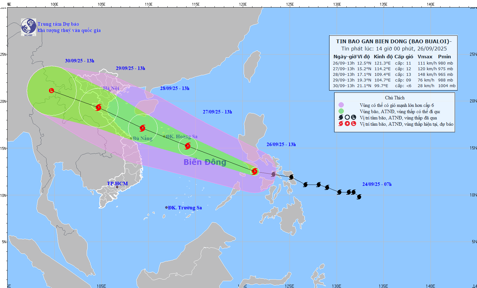
According to the National Center for Hydro-Meteorological Forecasting, at 1 p.m. on September 26, the center of the storm was at about 12.5°N - 121.3°E, in the central region of the Philippines. The strongest wind was level 11 (103 - 117 km/h), gusting to level 14, the storm moved in a West-Northwest direction, at a speed of 35 - 40 km/h.
Around tonight (September 26), storm BUALOI will enter the eastern sea area of the central East Sea, becoming storm number 10 in 2025. After entering the East Sea, the storm will move in the West-Northwest direction at a very fast speed (average 30km/hour, twice as fast as normal storms), towards the western sea area of Hoang Sa special zone.
At 1:00 p.m. on September 28, the storm moved in the West-Northwest direction, at a speed of 25-30 km/h, continuing to strengthen. The storm was located at 17.1°N - 109.4°E, wind force level 13, gust level 16, danger zone 13.0-20.0°N; 108.0-116.5°E, natural disaster risk level 3 (North and central East Sea, Hoang Sa, sea area off Thanh Hoa - Quang Ngai ). The storm is forecast to change direction, moving along the coast towards the North Central and Southern Northern Delta provinces.
At 1:00 p.m. on September 29, the storm moved in the West-Northwest direction, speed 25-30 km/h, storm location at 19.3°N - 104.7°E, wind force level 8 - 9, gust level 11. Dangerous area is North latitude 15.0°N; West longitude 112.0°E, natural disaster risk level 3 (Northwest and middle of East Sea, Hoang Sa, Thanh Hoa - Quang Ngai sea area, North Gulf of Tonkin including Bach Long Vy, Van Don, Co To, Cat Hai, Hon Dau).
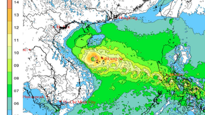
From September 28-30, the North, Thanh Hoa - Hue area will have very heavy rain.
Warning, storm continues to move rapidly to the West Northwest, 25-30 km per hour. Intensity gradually weakens.
Due to the influence of the storm, the North and Central East Sea (including Hoang Sa): wind level 6 - 7, increasing to level 8 - 9; near the storm center level 10 - 13, gusting to level 16. Waves 6 - 8 m high, near the storm center 8 - 10 m, rough seas.
On the evening of September 27, the sea area of Thanh Hoa - Quang Ngai (Hon Ngu, Con Co, Ly Son) had winds of level 6 - 7, gusts of 8 - 9, waves of 3 - 5 m. From early morning of September 28, winds of level 8 - 9, near the storm center, winds of level 10 - 13, gusts of 16, waves of 5 - 7 m, and rough seas.
Early morning of September 28, in the North of Bac Bo Gulf (Bach Long Vy, Van Don, Co To, Cat Hai, Hon Dau), the wind increased to level 6 - 7, then level 8 - 9, gusts 11, waves 3 - 5 m, very rough seas.
Experts warn that activities in dangerous areas are likely to be affected by storms, tornadoes, strong winds, and large waves.
On September 26, in the Northeast region, there will be moderate rain, heavy rain, locally very heavy rain and thunderstorms; in the area from Nghe An to Da Nang City and the Central Highlands, there will be scattered showers and thunderstorms, locally heavy to very heavy rain.
It is forecasted that from the evening of September 26 to the morning of September 27, in the Northeast, Phu Tho and Thanh Hoa, there will be moderate rain, heavy rain, and locally very heavy rain. The common rainfall will be 30-60mm, and locally 120mm. From the afternoon of September 27, the heavy rain will gradually decrease. There is a risk of heavy rain >100mm/3 hours.
In addition, in the evening and night of September 26, the Northwest region, from Nghe An to Lam Dong and the South, will have scattered showers and thunderstorms. Rainfall is generally 20-40mm, locally over 100mm. There is a risk of heavy rain >100mm/3 hours. During thunderstorms, there is a possibility of tornadoes, lightning, hail and strong gusts of wind.
In particular, from September 28-30, the North and the area from Thanh Hoa to Hue City are likely to experience widespread heavy rain. Total rainfall is generally 100-300 mm, locally over 400 mm. Particularly in the Northern Delta and the area from Thanh Hoa to Ha Tinh, it is generally 200-400 mm, locally over 600 mm.
Source: https://baotintuc.vn/xa-hoi/toi-269-bao-bualoi-di-vao-bien-dong-toc-do-nhanh-gap-doi-bao-binh-thuong-20250926163347715.htm

![[Photo] Prime Minister Pham Minh Chinh attends the groundbreaking ceremony of two key projects in Hai Phong city](https://vphoto.vietnam.vn/thumb/1200x675/vietnam/resource/IMAGE/2025/9/27/6adba56d5d94403093a074ac6496ec9d)


Comment (0)