
The strongest storm in the world since the beginning of 2025

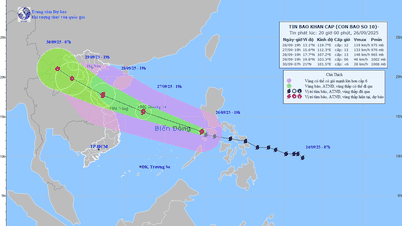
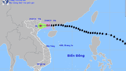
Giving a quick report on the developments and forecast of storm No. 9 at the meeting, Mr. Hoang Duc Cuong, Deputy Director of the Department of Hydrometeorology ( Ministry of Agriculture and Environment ) said that on September 22, while in the Northeast of the Philippines, storm No. 9 intensified into a super typhoon and moved into the East Sea on the morning of September 23. The super typhoon reached its strongest intensity of level 17, gusting above level 17.
According to the world's meteorological agencies, up to now, Ragasa storm is considered the strongest super storm in the world in 2025, surpassing both Erin storm (North Atlantic) and Yagi storm (2024).
Storm No. 9 is moving very fast, about 20-25km/hour. In about 36 hours, the storm will reach Leizhou (China), starting to affect the Gulf of Tonkin.
By early afternoon on September 23, the storm was no longer at its strongest and had weakened, from level 17 to level 16, then maintained and gradually decreased over the next 24 hours as it approached the coast of Guangdong (China). When there is friction with the terrain, plus the dry air flow of cold air from the North moving down, penetrating the center of the storm, the storm's intensity will decrease, from level 16 to level 12, gusting above level 12.
On land, it is forecasted that from the morning of September 25, coastal areas from Quang Ninh to Thanh Hoa will have winds gradually increasing to level 6-7, then increasing to level 8, areas near the storm center will have winds of level 9-10, gusting to level 12; areas deep inland in the Northeast will have strong winds of level 6-7, gusting to level 8-9.
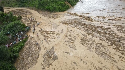
It is expected that due to rapid degradation when approaching the mainland, heavy rain will be concentrated in the entire North and Thanh Hoa, with the focus on Thai Nguyen, Tuyen Quang, Lao Cai, Phu Tho and the Northern Delta. Extreme rainfall is unlikely to occur, with rainfall of about 100-250mm expected during the entire period from September 25-26, with some places over 400mm, which could cause flooding in urban areas in the Northern Delta, affect reservoirs in the northern mountainous areas, and possibly cause landslides in mountainous areas...
Right after the rain circulation ends, it is expected that on September 27, a tropical depression will appear, possibly becoming storm No. 10, entering the East Sea, with a 50% chance of affecting our country. The Department of Hydrometeorology will continuously update information.
Localities must set the highest warning level.

At the meeting, Deputy Minister of Agriculture and Environment Nguyen Hoang Hiep said that ministries, branches and localities are urgently implementing Official Dispatch No. 170/CD-TTg dated September 22, 2025 of the Prime Minister, directing ministries, branches and localities to proactively respond to super typhoon Ragasa.
Noting some important points, Deputy Minister Nguyen Hoang Hiep emphasized: "Although the storm has weakened when it reached the mainland, the developments at sea are still very strong. Localities must set the highest warning level, limit ships going out to sea, especially long-term fishing vessels. Aquaculture activities on an area of 160,000 hectares of sea surface need to be protected. People should trim and harvest early to reduce damage."
In addition, although it has been weakened, storm No. 9 can still cause roofs to be blown off and trees to fall. Localities, especially Quang Ninh and Hai Phong, need to continue to reinforce houses, trim trees, and brace structures. When the storm comes ashore, combined with cold air, it will cause many dangerous thunderstorms on September 25-26. It is impossible to predict accurately, so it is absolutely necessary to ensure the safety of tourists and not let them stay on boats when the weather is bad.
Furthermore, storm No. 9 does not cause too much rain but is dangerous because many reservoirs in the North are full due to the accumulation of water at the end of the season. Localities must be on "wartime", monitor and operate reservoirs safely. In addition, the dyke system has been invested, but special attention is still needed at river mouths and high tide areas.
Notably, the North still has about 850,000 hectares of rice, of which 200,000 hectares can be harvested immediately. Therefore, localities must urgently harvest the rice area that can be harvested immediately, "green at home is better than old in the field", to reduce damage. For the remaining rice area and fruit trees, timely drainage solutions are needed.
Regarding this issue, Deputy Prime Minister Tran Hong Ha noted that with just over a day left before storm No. 9 directly impacts, localities need to urgently review, harvest, and utilize aquatic products that are ready to be exploited, to reduce damage, while ensuring absolute safety for fishermen.
Forecasting agencies need to issue early warnings about the risk of thunderstorms, even when there are no clear signs, so that people can proactively take precautions.
Emphasizing the need to ensure the safety of reservoirs, especially hydroelectric reservoirs, must be given top priority, the Deputy Prime Minister requested the Ministry of Agriculture and Environment to closely coordinate with the Ministry of Industry and Trade - the agency managing most hydroelectric reservoirs, and meteorological forecasting units to operate, control water levels, forecast accurately and have timely solutions.
Implement the motto "4 on-site"

Speaking online at the meeting, Chairman of Quang Ninh Provincial People's Committee Bui Van Khang emphasized two experiences: Always be ready to respond at the highest level, not be subjective and organize forces, means and resources on the spot. Currently, Quang Ninh has established a Civil Defense Command Committee in 54 communes, especially border communes and island communes, with a force of about 13,000 people, including soldiers, police, sectors and businesses in the area.
Means mobilized from the military, businesses and people are ready for storm prevention and control. Localities thoroughly implement the "4 on-site" motto; at the same time, have detailed plans for evacuation such as: number of households to be evacuated, means of transport, accommodation and living space for people as well as plans to ensure security and protect property - the factors that people worry about most when having to evacuate.
Regarding production, Quang Ninh province expects that storm No. 9 may affect 4,158 fishing boats, 479 tourist boats, and nearly 8,000 aquaculture facilities, including 800 offshore facilities with about 3,000 workers. The province has informed these entities to be ready to evacuate when ordered.
Reporting online at the meeting, Chairman of Ninh Binh Provincial People's Committee Nguyen Quang Ngoc said that the province has seriously implemented the Prime Minister's instructions on responding to storm No. 9. Up to now, 100% of ships and vehicles operating at sea have been notified, of which 1,485 ships (about 80% of the ships) have anchored safely, the rest are returning to shore. Ninh Binh has also prepared a plan to prevent and avoid coastal areas and areas at risk of flooding, and established inspection and supervision teams in key areas.
Ninh Binh province plans to ban the sea from 7am on September 24, 2025, while reviewing plans to evacuate people and inspect key dykes. For the Hoang Long river flood area, the flood prevention and control system has been strengthened. As for the Hai Hau sea dyke, the construction progress is being accelerated but there are still weaknesses. The province continues to invest and apply the "4 on-site" motto to proactively respond.
Regarding Ha Tinh province, Standing Vice Chairman of the Provincial People's Committee Nguyen Hong Linh informed that 100% of the armed forces, police, and border guards were on duty. Currently, there are only 8 ships with 45 workers at sea, which have been in contact and are moving to a safe anchorage. Regarding production, the locality has basically finished harvesting rice and directed the urgent harvesting of fruit trees to reduce damage. Plans to ensure safety for aquaculture have also been deployed...
According to Lieutenant General Doan Thai Duc, Chief of Office of the National Civil Defense Steering Committee, the Ministry of National Defense has issued four dispatches directing all agencies and units in areas expected to be affected by the storm, including Military Regions 1, 2, 3, 4, the Navy, the Air Defense - Air Force, army corps and army corps, to "be fully on duty, ready to participate in handling situations". In addition, 34 provinces and cities have implemented 24/7 duty at the phone number 112 to receive information on natural disasters, catastrophes, risks and requests for help from people, including offshore fishing vessels, and mobilize forces to handle them.
Thoroughly understand the principle that "no storm is mild"

Concluding the meeting, the Deputy Prime Minister emphasized: The principle of responding to storms is that "no storm is mild", because each storm is accompanied by many abnormal factors, affecting before, during and after making landfall.
Appreciating the coordination, monitoring, assessment and forecasting of the storm by the Department of Hydrometeorology, Ministry of Agriculture and Environment; and the proactive participation of localities, the Deputy Prime Minister requested all levels, sectors and localities to continue to thoroughly grasp the motto "prevention is the main thing, discipline and order are top priority", must keep information clear, update the situation continuously, and have plans to handle situations promptly.
The Deputy Prime Minister requested the Office of the National Civil Defense Steering Committee and provinces and cities to develop scenarios and specific response plans, and to standardize procedures for synchronous coordination, to be able to mobilize forces and means on the spot; and at the same time, organize drills to ensure smooth operation when a big storm occurs.
At sea, the Ministry of Agriculture and Environment, the Ministry of National Defense and other forces must issue bulletins, control vessels, and guide fishermen to escape from dangerous areas and move to safe shelters. Localities need to urgently support people to reinforce and protect aquaculture areas to avoid major damage. At the same time, they must calculate plans to protect property, because this is the biggest concern when people are forced to evacuate.
On land, localities tighten the "4 on-site" mechanism, especially ensuring electricity, gasoline, and communications, and even having to prepare generators and backup vehicles to maintain operations in case of incidents.
The Deputy Prime Minister assigned the Ministry of Agriculture and Environment and the Ministry of Industry and Trade to coordinate in inspecting, evaluating, and properly operating the inter-reservoir process, ensuring safety in all situations.
Although it has been downgraded, storm No. 9 still has the potential for tornadoes, heavy rains, and safety risks. Therefore, meteorological agencies must increase forecasts with images and easy-to-understand warning information so that people can clearly understand and proactively prevent it.
Noting that after storm No. 9 there is a possibility of a new tropical depression or storm appearing, the Deputy Prime Minister requested ministries, branches and localities to immediately prepare further response plans.
Source: https://baotintuc.vn/thoi-su/ung-pho-voi-sieu-bao-ragasa-pho-thu-tuong-tran-hong-ha-yeu-cau-khong-duoc-chu-quan-20250923160750596.htm

![[Photo] Prime Minister Pham Minh Chinh attends the groundbreaking ceremony of two key projects in Hai Phong city](https://vphoto.vietnam.vn/thumb/1200x675/vietnam/resource/IMAGE/2025/9/27/6adba56d5d94403093a074ac6496ec9d)


Comment (0)