
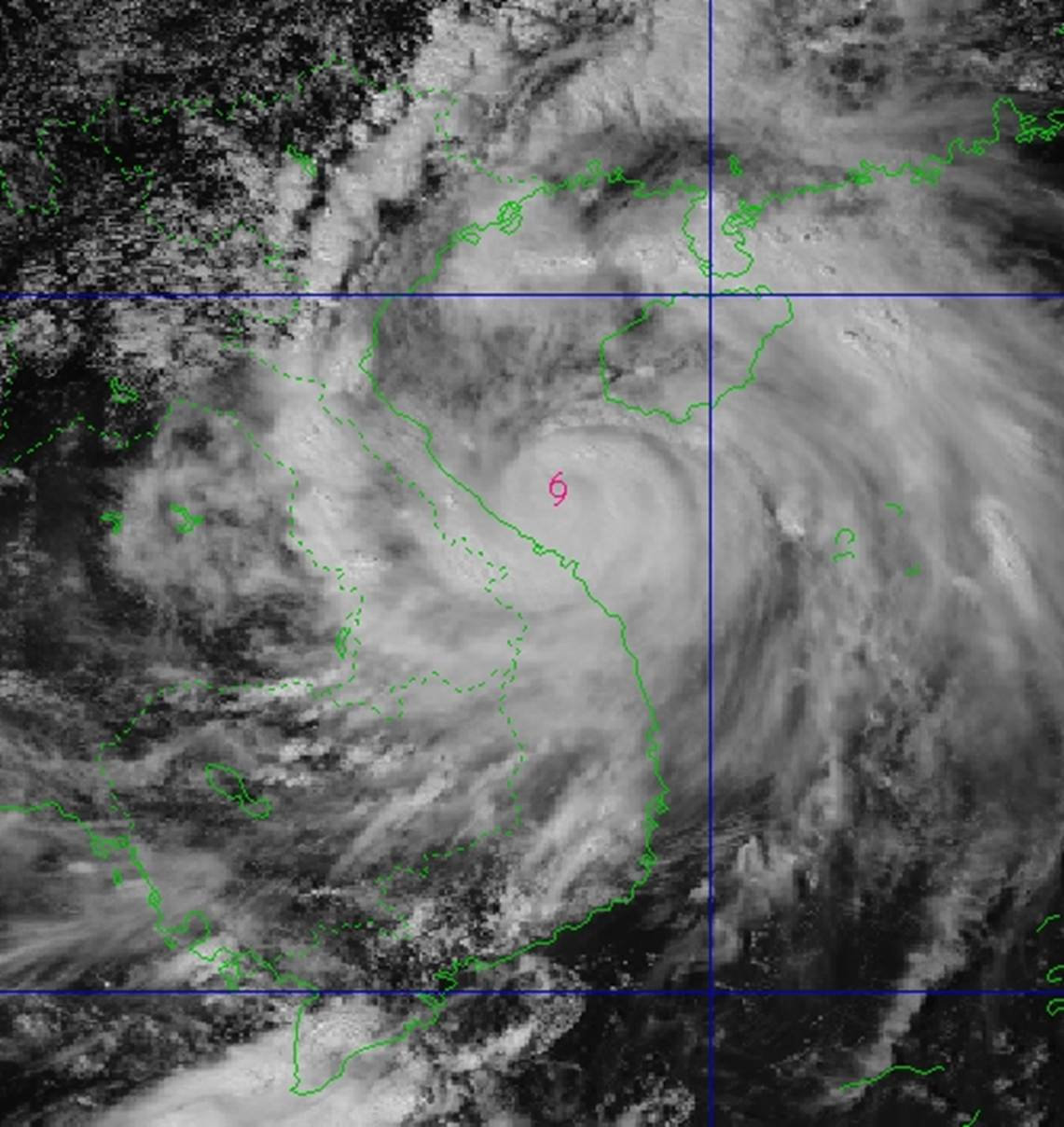
At 2:00 p.m. on September 28, the center of storm No. 10 was at about 17.2° North latitude; 108.1° East longitude, about 90km East Northeast of Hue City, about 165km South Southeast of Northern Quang Tri .
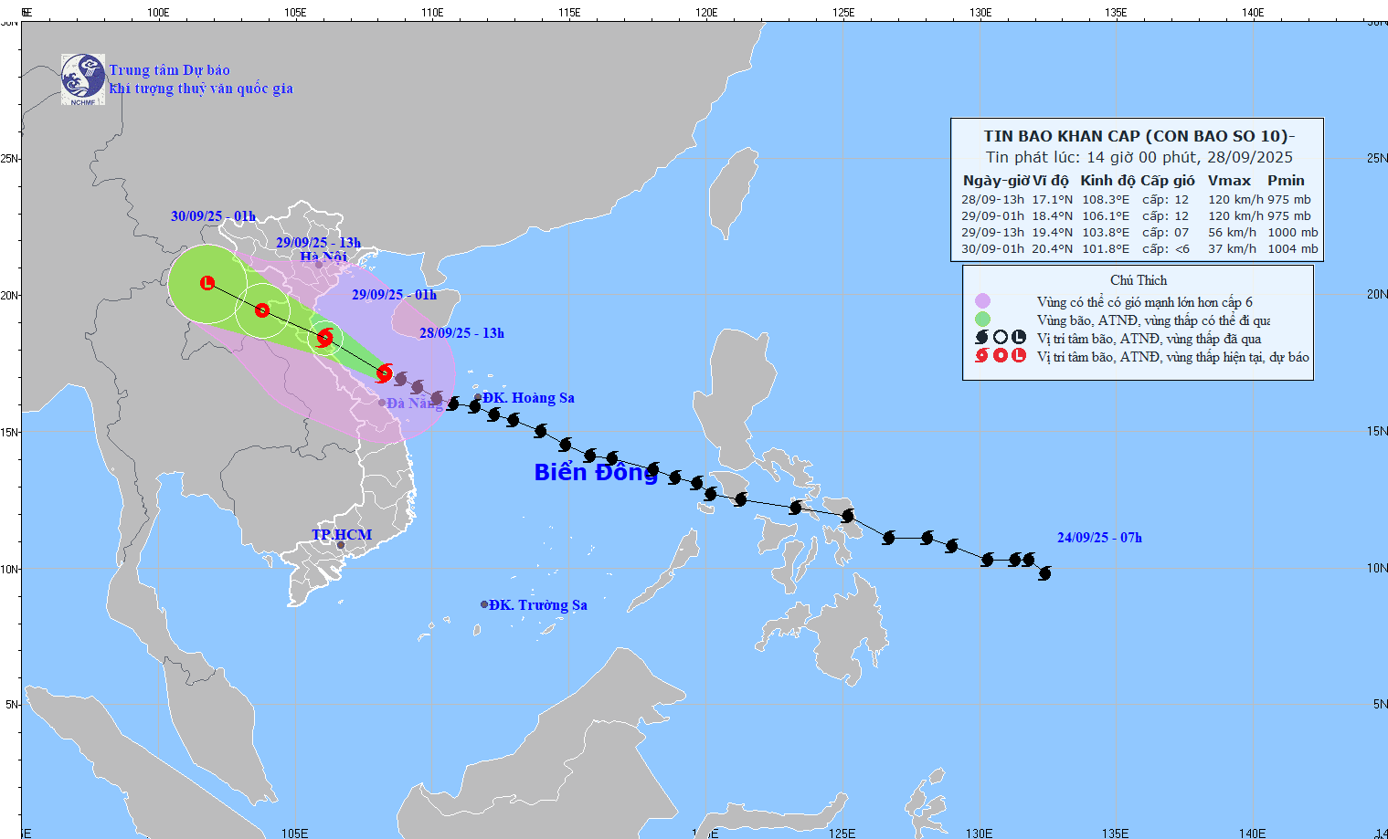 |
According to the National Center for Hydro-Meteorological Forecasting, the strongest wind near the storm's eye reached level 12 (118-133 km/h), gusting to level 15.
Forecast in the next 3 hours, the storm moves to the West Northwest at a speed of 20-25 km/h.
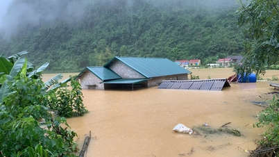
In the past 24 hours, heavy rain appeared in many localities from Thanh Hoa to Quang Ngai, some places had very heavy rainfall: Huong Nguyen (Thua Thien - Hue) 490.4mm; Ta Rut (Quang Tri) 275mm; Que Phuoc ( Da Nang ) 206mm; Yen Thuong (Nghe An) 110.2mm; Cam Luong (Thanh Hoa) 62.6mm; Binh Khuong (Quang Ngai) 114.8mm.
In the next 6 hours, the National Center for Hydro-Meteorological Forecasting warns of a high risk of flash floods on small rivers and streams, and landslides in many areas. Disaster risk level: level 1, Hue City level 2.
Flash floods and landslides can cause serious damage, threaten people's lives, disrupt traffic, destroy civil works and production, and affect the socio-economy in the Central provinces.
 |
| Storm center location: About 17.2 degrees North latitude; 108.1 degrees East longitude, about 90km East Northeast of Hue City, about 165km South Southeast of North Quang Tri. |
According to Hai Ha/ VOV.VN
Source: https://baovinhlong.com.vn/thoi-su/202509/bao-so-10-con-cach-tp-hue-khoang-90km-tinh-quang-tri-khoang-165km-df921ab/
![[Photo] Panorama of the cable-stayed bridge, the final bottleneck of the Ben Luc-Long Thanh expressway](https://vphoto.vietnam.vn/thumb/1200x675/vietnam/resource/IMAGE/2025/9/30/391fdf21025541d6b2f092e49a17243f)

![[Photo] General Secretary To Lam, Secretary of the Central Military Commission attends the 12th Party Congress of the Army](https://vphoto.vietnam.vn/thumb/1200x675/vietnam/resource/IMAGE/2025/9/30/9b63aaa37ddb472ead84e3870a8ae825)
![[Photo] Solemn opening of the 12th Military Party Congress for the 2025-2030 term](https://vphoto.vietnam.vn/thumb/1200x675/vietnam/resource/IMAGE/2025/9/30/2cd383b3130d41a1a4b5ace0d5eb989d)
![[Photo] The 1st Congress of Phu Tho Provincial Party Committee, term 2025-2030](https://vphoto.vietnam.vn/thumb/1200x675/vietnam/resource/IMAGE/2025/9/30/1507da06216649bba8a1ce6251816820)
![[Photo] President Luong Cuong receives President of the Cuban National Assembly Esteban Lazo Hernandez](https://vphoto.vietnam.vn/thumb/1200x675/vietnam/resource/IMAGE/2025/9/30/4d38932911c24f6ea1936252bd5427fa)


Comment (0)