
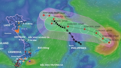
Latest storm news: Currently, while storm No. 7 Yinxing is still raging in the East Sea with strong winds and large waves, forecasts show that storm TORAJI will follow, entering the East Sea on November 12. It is expected that TORAJI can reach gusts of level 11, becoming the 8th storm this year.
Latest storm news: Update on the location and path of storm No. 7 Yinxing
While storm number 7 Yinxing is still raging in the East Sea, causing strong winds and huge waves, storm TORAJI is forecast to continue entering the East Sea on November 12 with level 11 gusts, becoming storm number 8 of the year.
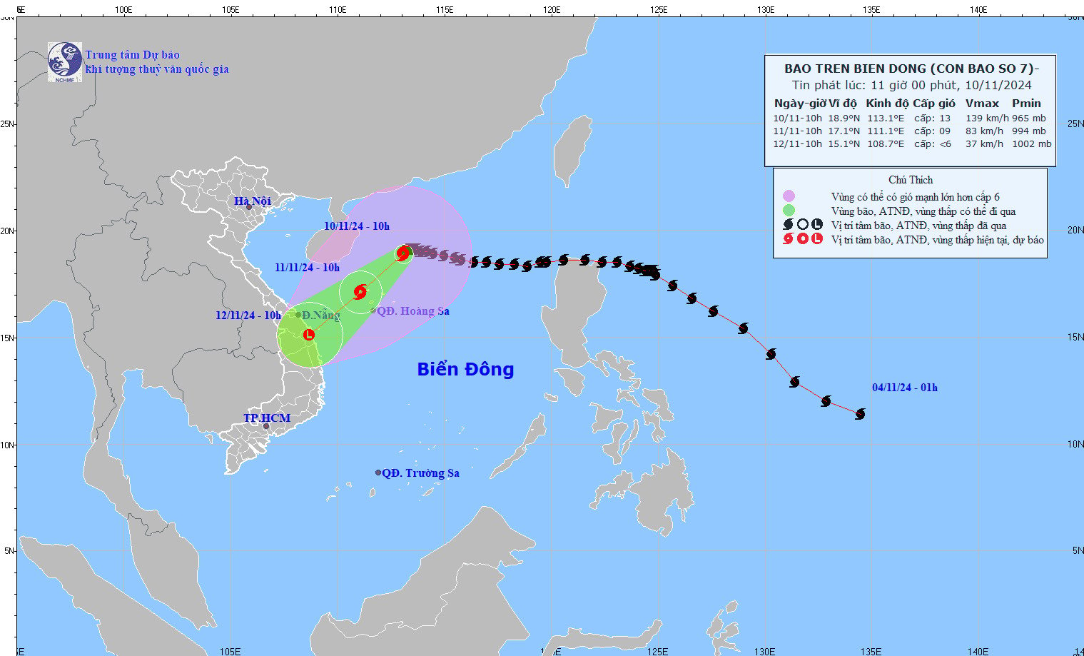
Latest storm news: Updated location and path of storm No. 7 Yinxing. Photo: NCHMF
According to the latest forecast of the National Center for Hydro-Meteorological Forecasting, at 10:00 (November 10), the center of storm No. 7 Yinxing was located at about 18.9 degrees North latitude; 113.1 degrees East longitude, in the western sea area of the North East Sea, about 250km northeast of the Hoang Sa archipelago. The strongest wind near the center of the storm is level 12-13 (118-149km/h), gusting to level 16. Moving in the West Southwest direction, speed about 5km/h.
Forecast of storm No. 7 in the next 24 to 48 hours
Forecast time | Direction, speed | Location | Intensity | Danger zone | Disaster Risk Level (Affected Area) |
10:00 a.m. November 11, 2011 | Southwest, about 10km/h, continuing to weaken | 17.1N-111.1E; in the sea northwest of Hoang Sa archipelago | Level 9, level 11 | Latitude 15.5N-21.0N; longitude 109.5E-115.0E | Level 3: Western sea area of the North East Sea (including the sea area of Hoang Sa archipelago) |
10:00 a.m., December 11, 2011 | Southwest, about 15km/h, weakening into a low pressure area | 15.1N-108.7E; on land from Quang Nam to Binh Dinh | Latitude 14.5N-19.0N; West of longitude 113.0E | Level 3: western sea area of the North East Sea (including the sea area of Hoang Sa archipelago), offshore sea area of Quang Tri to Quang Ngai |
On the impact of storm number 7
At sea: The western sea area of the North East Sea (including the sea area of Hoang Sa archipelago) has strong winds of level 7-9, the area near the storm's eye has winds of level 10-13, gusts of level 16, waves 4.0-6.0m high, the area near the eye has waves of 6.0-8.0m; the sea is very rough.
From early morning on November 11, the sea off the coast of Quang Tri to Quang Ngai has gradually increased winds to level 6-7, gusting to level 9, waves 2.0-4.0m high; rough seas.
Vessels operating in the above mentioned dangerous areas are susceptible to the impact of storms, whirlwinds, strong winds and large waves.
To proactively respond to the developments of storm TORAJI, the Minister of Agriculture and Rural Development has just issued a telegram requesting ministries, branches, and Chairmen of People's Committees of coastal provinces and cities from Quang Ninh to Binh Thuan to closely monitor the developments of the storm; manage means of transport going out to sea; organize the counting of ships and boats; notify owners of means of transport, captains of ships and boats operating at sea of the location, direction of movement and developments of the storm to proactively avoid, escape or not move into dangerous areas. Dangerous areas in the next 24 hours: From latitude 16.5-21.0 degrees North latitude, east of longitude 119.0 degrees East longitude; in the next 48 hours: From latitude 15.0-21.0 degrees North latitude, east of longitude 117.5 degrees East longitude (dangerous areas are adjusted according to forecast bulletins). Be ready with forces and means for rescue when requested.
Vietnam Television, Voice of Vietnam, Vietnam News Agency, the coastal information station system and mass media agencies from central to local levels have increased measures to inform authorities and people about the storm's developments to proactively prevent and respond promptly and effectively.
Ministries and branches, according to their state management functions and tasks and assigned tasks, proactively direct and coordinate with localities to respond to storm developments.
On duty seriously (24/24 hours), regularly report to the Ministry of Agriculture and Rural Development (through the Department of Dike Management and Disaster Prevention and Control).
Source: https://danviet.vn/tin-bao-moi-nhat-chuoi-bao-noi-duoi-tren-bien-dong-bao-so-8-toraji-se-den-sau-bao-so-7-yinxing-20241110111252598.htm
![[Photo] The 1st Congress of Phu Tho Provincial Party Committee, term 2025-2030](https://vphoto.vietnam.vn/thumb/1200x675/vietnam/resource/IMAGE/2025/9/30/1507da06216649bba8a1ce6251816820)

![[Photo] Panorama of the cable-stayed bridge, the final bottleneck of the Ben Luc-Long Thanh expressway](https://vphoto.vietnam.vn/thumb/1200x675/vietnam/resource/IMAGE/2025/9/30/391fdf21025541d6b2f092e49a17243f)
![[Photo] Solemn opening of the 12th Military Party Congress for the 2025-2030 term](https://vphoto.vietnam.vn/thumb/1200x675/vietnam/resource/IMAGE/2025/9/30/2cd383b3130d41a1a4b5ace0d5eb989d)
![[Photo] General Secretary To Lam, Secretary of the Central Military Commission attends the 12th Party Congress of the Army](https://vphoto.vietnam.vn/thumb/1200x675/vietnam/resource/IMAGE/2025/9/30/9b63aaa37ddb472ead84e3870a8ae825)
![[Photo] President Luong Cuong receives President of the Cuban National Assembly Esteban Lazo Hernandez](https://vphoto.vietnam.vn/thumb/1200x675/vietnam/resource/IMAGE/2025/9/30/4d38932911c24f6ea1936252bd5427fa)


Comment (0)