
Forecast on September 23, storm RAGASA enters the North East Sea area
Accordingly, a storm with the international name RAGASA is currently active in the sea east of the Philippines. At 7:00 a.m. on September 19, the center of the storm was at about 15.7 degrees North latitude, 131.9 degrees East longitude; the strongest wind near the center of the storm was level 8, gusting to level 10.
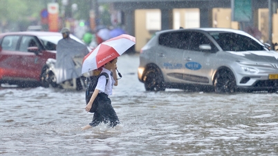
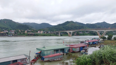
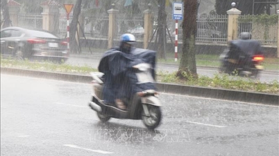
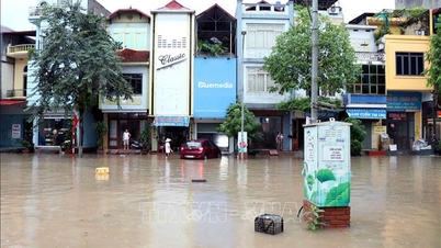
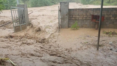
It is forecasted that by September 23, the storm will enter the North East Sea with winds of level 14-16, gusts of over level 17, waves over 10 meters high, rough seas, especially dangerous for ships operating in the North and Central East Sea. Due to the influence of storm RAGASA, from the afternoon of September 22, the eastern sea of the North East Sea will have strong winds of level 8-9.
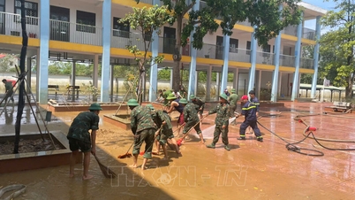
To proactively respond to the storm, the National Steering Committee for Civil Defense recommends that the above provinces and cities closely monitor warning bulletins, forecasts and developments of the storm; notify captains and owners of vehicles and vessels operating at sea to proactively prevent and have appropriate production plans, ensuring safety of people and property; maintain communication to promptly handle bad situations that may occur.
Localities are ready with forces and means to deploy rescue work when there is a situation, and at the same time organize serious on-duty shifts and regularly report to the National Civil Defense Steering Committee ( Ministry of Agriculture and Environment ).
Storm No. 8 on mainland Guangdong province (China)
Along with that, according to the National Center for Hydro-Meteorological Forecasting, on the afternoon of September 19, storm No. 8 entered the mainland area south of Guangdong province (China).
At 4 p.m., the eye of the storm was at approximately 22.9 degrees North latitude; 115.1 degrees East longitude, on the mainland south of Guangdong province (China). The strongest wind near the eye of the storm was level 8-9 (62-88 km/h), gusting to level 11. Moving northwest at a speed of approximately 10 km/h.
At 4:00 a.m. on September 20, the storm was on land in the southern part of Guangdong province (China); moving in the West Northwest direction at a speed of about 10-15 km/h with strong winds of level 6, gusts of level 8. The affected area is the northern sea area of the North East Sea. Disaster risk level 3.
At 4:00 p.m. on September 20, the storm was on the mainland south of Guangdong province (China); moving west at a speed of 15 km/h, entering the mainland and gradually weakening into a low pressure area. Wind force below level 6.
Due to the storm's influence, the northern sea area of the North East Sea has strong winds of level 6-7, gusting to level 9; the area near the storm's center has strong winds of level 8, gusting to level 10, waves 3-4.5m high, rough seas.
Vessels operating in the above mentioned dangerous areas are susceptible to the impact of storms, whirlwinds, strong winds and large waves.
Source: https://baotintuc.vn/van-de-quan-tam/ban-chi-dao-phong-thu-dan-su-quoc-gia-chi-dao-ung-pho-voi-sieu-baoragasa-20250919174440638.htm

![[Photo] Solemn opening of the 12th Military Party Congress for the 2025-2030 term](https://vphoto.vietnam.vn/thumb/1200x675/vietnam/resource/IMAGE/2025/9/30/2cd383b3130d41a1a4b5ace0d5eb989d)

![[Photo] General Secretary To Lam receives US Ambassador to Vietnam Marc Knapper](https://vphoto.vietnam.vn/thumb/1200x675/vietnam/resource/IMAGE/2025/9/29/c8fd0761aa184da7814aee57d87c49b3)
![[Photo] General Secretary To Lam, Secretary of the Central Military Commission attends the 12th Party Congress of the Army](https://vphoto.vietnam.vn/thumb/1200x675/vietnam/resource/IMAGE/2025/9/30/9b63aaa37ddb472ead84e3870a8ae825)
![[Photo] The 1st Congress of Phu Tho Provincial Party Committee, term 2025-2030](https://vphoto.vietnam.vn/thumb/1200x675/vietnam/resource/IMAGE/2025/9/30/1507da06216649bba8a1ce6251816820)


![[Photo] General Secretary To Lam attends the ceremony to celebrate the 80th anniversary of the post and telecommunications sector and the 66th anniversary of the science and technology sector.](https://vphoto.vietnam.vn/thumb/1200x675/vietnam/resource/IMAGE/2025/9/29/8e86b39b8fe44121a2b14a031f4cef46)


Comment (0)