
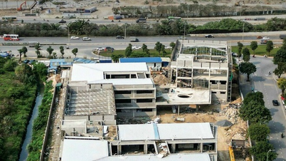
According to the Decision, the land plot marked D1/ODK11 in the H2-3 Urban Zoning Plan, scale 1/2000, belongs to the administrative boundary of Dinh Cong ward, Hoang Mai district, the Northeast borders the planned road B = 17.5m; the Northwest and Southwest borders the planned road B = 13.5m; the Southeast borders the planned road B = 11.5m. The total research land area is about 7,458m².
The purpose of the adjustment is to update and supplement the content of the H2-3 Urban Zoning Plan, scale 1/2000, which has been approved by the Hanoi People's Committee. It meets the needs of building barracks, ensuring national defense and security of the city, improving land use efficiency; as a basis for organizing the establishment of local adjustments to the detailed planning scale 1/500 and subsequent procedures on investment, land... and as a basis for authorities at all levels to carry out construction investment management according to the law.
Accordingly, the land use function will be adjusted from newly built residential land to security and defense land. The architectural planning indicators (construction density, height) will be determined specifically and accurately in the next phase according to the requirements and purposes of using security and defense land approved by competent authorities.
The Hanoi People's Committee assigned the Department of Planning and Architecture to confirm the local planning adjustment drawings in accordance with this decision; and to archive planning project documents according to regulations.
The People's Committee of Hoang Mai district presides over and coordinates with relevant agencies and units to organize the public announcement of the approved local planning adjustments so that relevant organizations, agencies and people can know.
Source: https://kinhtedothi.vn/dieu-chinh-cuc-bo-quy-hoach-phan-khu-do-thi-h2-3-o-quan-hoang-mai.html
![[Photo] General Secretary To Lam receives US Ambassador to Vietnam Marc Knapper](https://vphoto.vietnam.vn/thumb/1200x675/vietnam/resource/IMAGE/2025/9/29/c8fd0761aa184da7814aee57d87c49b3)

![[Photo] General Secretary To Lam, Secretary of the Central Military Commission attends the 12th Party Congress of the Army](https://vphoto.vietnam.vn/thumb/1200x675/vietnam/resource/IMAGE/2025/9/30/9b63aaa37ddb472ead84e3870a8ae825)

![[Photo] Solemn opening of the 12th Military Party Congress for the 2025-2030 term](https://vphoto.vietnam.vn/thumb/1200x675/vietnam/resource/IMAGE/2025/9/30/2cd383b3130d41a1a4b5ace0d5eb989d)
![[Photo] The 1st Congress of Phu Tho Provincial Party Committee, term 2025-2030](https://vphoto.vietnam.vn/thumb/1200x675/vietnam/resource/IMAGE/2025/9/30/1507da06216649bba8a1ce6251816820)


![[Photo] General Secretary To Lam attends the ceremony to celebrate the 80th anniversary of the post and telecommunications sector and the 66th anniversary of the science and technology sector.](https://vphoto.vietnam.vn/thumb/1200x675/vietnam/resource/IMAGE/2025/9/29/8e86b39b8fe44121a2b14a031f4cef46)


Comment (0)