
The storm is moving northwest at a speed of 20 km/h.
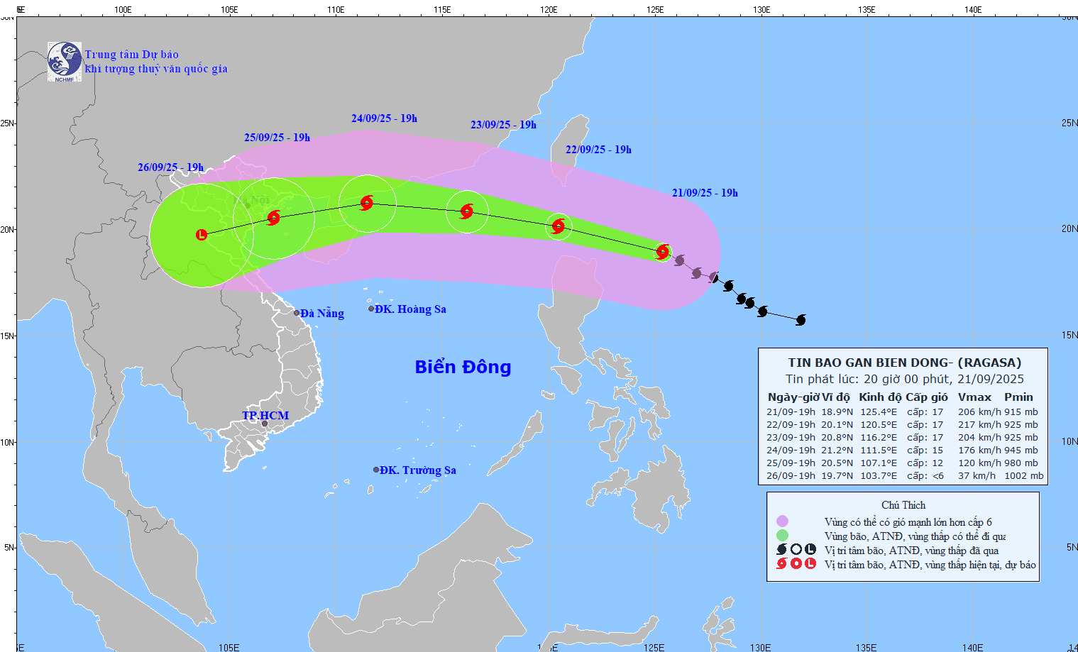
At 7:00 p.m. on September 22, the storm was about 120 km northwest of Luzon Island (Philippines) with strong winds of level 17, gusting above level 17; moving west-northwest at a speed of about 20 km/h and continuing to strengthen. The affected area is the northeastern sea area of the North East Sea. Disaster risk level 4.
By 7:00 p.m. on September 23, the storm was in the northern sea, the North Northeast region with strong winds of level 16-17, gusting over level 17; moving in the West Northwest direction at a speed of about 20 km/h and entering the East Sea. The affected area is the northern sea area of the North East Sea. Disaster risk level 4.
At 7:00 p.m. on September 24, the storm was in the sea of Guangdong province (China) with strong winds of level 14-15, gusting over level 17; moving in the West Northwest direction at a speed of about 15-20 km/h and gradually weakening. The affected area is the North East Sea. Disaster risk level 4.
From the next 72 to 120 hours, the storm will move mainly in the West Southwest direction, about 20km per hour, and continue to weaken.
Associate Professor, PhD, Director of the National Center for Hydro-Meteorological Forecasting Mai Van Khiem warned: Due to the influence of the storm, from September 22, the sea area in the East of the North East Sea will have strong winds gradually increasing to level 8-9, then increasing to level 10-14, the area near the storm's center will have winds of level 15-17, gusts above level 17, waves over 10m high, and rough seas.
Vessels operating in the above mentioned dangerous areas are susceptible to the impact of storms, whirlwinds, strong winds and large waves.
Beware of flash floods and landslides from Quang Ngai to Khanh Hoa
The National Center for Hydro-Meteorological Forecasting said that from 8:30 p.m. on September 21 to 1:30 a.m. on September 22, the provinces from Quang Ngai to Khanh Hoa will continue to have rain with accumulated rainfall ranging from 10-20 mm in Quang Ngai, over 40 mm in some places; from 20-40 mm in Gia Lai, Dak Lak and Khanh Hoa provinces, over 60 mm in some places.
Warning of the risk of flash floods on small rivers and streams, landslides on steep slopes in many communes/wards: Tu Mo Rong; Dak Pek, Dak Plo, Kon Dao, Mang Ri, Mo Rai, Ro Koi, Son Ha, Tay Tra (Quang Ngai province); Ayun, Binh Phu, Canh Vinh, Dak Somei, Ia Mo, Ia Nan, Ia Pnôn, Vinh Thanh (Gia Lai province); Hoa Thinh; Buon Don, Dak Phoi, Duc Binh, Ea H'Leo, Ea Knop, Ea Sup, Ea Wy, Hoa My, Krong No, Lien Son Lak, Phu Hoa 1, Phu Hoa 2, Phu Xuan, Tuy An Tay, Xuan Lanh, Xuan Phuoc (Dak Lak province); Bac Ninh Hoa, Dai Lanh, Lam Son, Nam Khanh Vinh, Ninh Son, Bac Cam Ranh, Trung Khanh Vinh, Tu Bong, Van Hung (Khanh Hoa province).
Level of natural disaster risk due to flash floods, landslides, land subsidence due to heavy rain or level 1 flow.
Flash floods and landslides can have very negative impacts on the environment, threaten people's lives; cause local traffic congestion, affect the movement of vehicles; destroy civil and economic works, causing damage to production and socio-economic activities.
The hydrometeorological agency recommends that local authorities pay attention to reviewing bottlenecks and vulnerable locations in the area to have prevention and response measures.
From 1 p.m. to 7 p.m. on September 21, the provinces from Quang Ngai to Khanh Hoa had moderate to heavy rain such as: Dak Ha1 (Quang Ngai) 93.4mm; Vinh An (Gia Lai) 85.9mm; Hoa Thinh (Dak Lak) 107.8mm; Ninh Son (Khanh Hoa) 75.5mm;...
Soil moisture models show that some areas in the above provinces are close to saturation (over 85%) or have reached saturation.
Source: https://baotintuc.vn/van-de-quan-tam/sieu-bao-ragasa-doi-huong-voi-suc-gio-manh-cap-17-giat-tren-cap-17-20250921210356664.htm

![[Photo] Prime Minister Pham Minh Chinh attends the groundbreaking ceremony of two key projects in Hai Phong city](https://vphoto.vietnam.vn/thumb/1200x675/vietnam/resource/IMAGE/2025/9/27/6adba56d5d94403093a074ac6496ec9d)


Comment (0)