
Warning of risk of heavy rain over 100mm in 3 hours
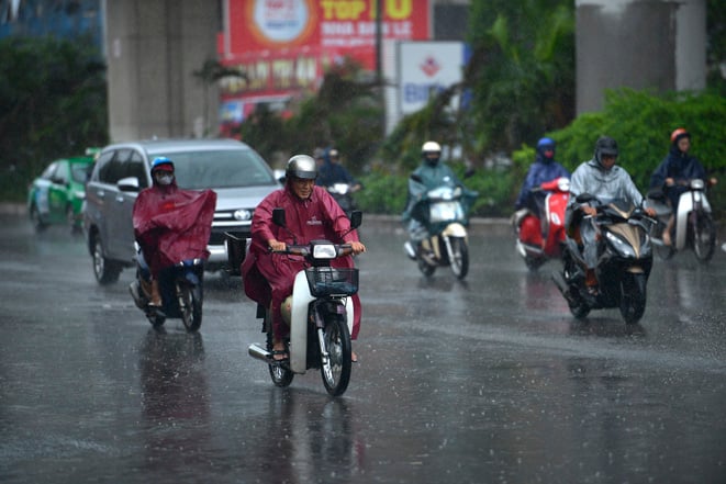
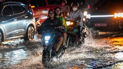
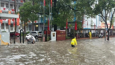
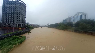
The National Center for Hydro-Meteorological Forecasting predicts that from the evening of September 25 to the morning of September 27, the Northern region, Thanh Hoa and Nghe An will have moderate rain, heavy rain, and locally very heavy rain, with common rainfall of 50-120mm, and locally over 200mm.
Warning of risk of heavy rain over 100mm in 3 hours.
In addition, in the afternoon and evening of September 25, the Central Highlands and the South will have scattered showers and thunderstorms with rainfall of 10-30mm, with some places having heavy rain of over 70mm.
Warning of risk of heavy rain over 60mm in 3 hours.
From the afternoon of September 27, heavy rain in the Northern region, Thanh Hoa and Nghe An gradually decreased. The risk of natural disasters due to heavy rain, tornadoes, lightning, and hail is level 1.
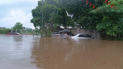
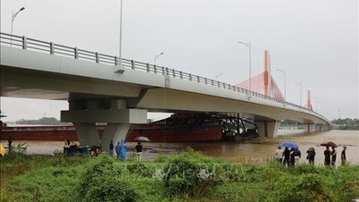
Deputy Head of Weather Forecasting Department Le Thi Loan noted: "Heavy rain is likely to cause flooding in low-lying areas, urban and industrial areas; flash floods on small rivers and streams, landslides on steep slopes (real-time warning information on areas at risk of flash floods and landslides is provided online on the website of the Department of Hydrometeorology at: https://luquetsatlo.nchmf.gov.vn and in a separate bulletin warning of flash floods and landslides), in thunderstorms there is a possibility of tornadoes, lightning, hail and strong gusts of wind".
On September 25, the Northeast region and the Central Highlands will have scattered showers and thunderstorms, with some places experiencing heavy rain. The rainfall from 7am to 3pm on September 25 was locally over 40mm in some places, such as: Mau Son station ( Lang Son ) 48.2mm, Dak Glei station (Quang Ngai) 45.2mm,...
Many sea areas have strong winds and high waves.
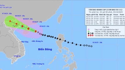
According to the National Center for Hydro-Meteorological Forecasting, there are currently strong winds of level 7, gusts of level 8, and waves of 2 meters in Bach Long Vi special zone. Northern Bac Bo Gulf, northern, central, and southern East Sea (including Hoang Sa and Truong Sa special zones) have scattered showers and thunderstorms.
On the night of September 25 and 26, from Khanh Hoa to Can Tho city, the central and southern East Sea area (including Truong Sa special zone) will have strong winds of level 6, gusts of level 7-8, rough seas, and waves 2-4m high.
In the North of the North East Sea, the wind is level 5, sometimes level 6, gusting to level 7-8, rough sea, waves 2-4m high.
On the evening of September 26, in the East of the North and Central East Sea, the wind gradually increased to level 6-7, gusting to level 8-9, rough seas, waves 2-4m high.
In addition, on the night of September 25 and 26, the Gulf of Tonkin, the North East Sea area (including Hoang Sa special zone), the central and South East Sea area (including Truong Sa special zone), the sea area from South Quang Tri to Ca Mau, Ca Mau to An Giang and the Gulf of Thailand will have scattered showers and thunderstorms, with the possibility of tornadoes, strong gusts of wind of level 6-7, and waves over 2m high.
Warning: On the night of September 26 and 27, the sea area from Khanh Hoa to Ho Chi Minh City, the sea area west of the area between the East Sea and the South East Sea area (including Truong Sa special zone) will have strong southwest winds of level 6, gusting to level 7-8; waves 2-4m high; rough seas.
The eastern sea area of the North and central East Sea has strong winds of level 6-7, then increasing to level 8-9, the area near the storm's eye has winds of level 10-12, gusting to level 15; waves 5-7m high; rough seas.
Marine disaster risk level 2
All vessels operating in the above areas are at high risk of being affected by very strong winds and very large waves.
Weather in different regions on the night of September 25 and September 26
The Northwest region has moderate to heavy rain and thunderstorms, locally very heavy rain, with the possibility of tornadoes, lightning and strong gusts of wind. The lowest temperature is 22-25 degrees Celsius, in some places below 21 degrees Celsius. The highest temperature is 27-30 degrees Celsius.
The Northeast region has moderate rain, heavy rain and thunderstorms, locally very heavy rain, with the possibility of tornadoes, lightning and strong gusts of wind. East wind level 2-3. Lowest temperature 22-25 degrees Celsius, in mountainous areas below 22 degrees Celsius. Highest temperature 28-31 degrees Celsius.
Hanoi city has rain, moderate rain and thunderstorms, some places have heavy rain, in thunderstorms there is a possibility of tornadoes, lightning and strong gusts of wind. East wind level 2-3. Lowest temperature 23-25 degrees Celsius. Highest temperature 29-31 degrees Celsius.
Provinces and cities from Thanh Hoa to Hue, in the North there will be moderate rain, heavy rain and thunderstorms, locally very heavy rain; in the South there will be scattered showers and thunderstorms, with the possibility of tornadoes, lightning, hail and strong gusts of wind. The lowest temperature will be from 24-27 degrees Celsius. The highest temperature will be from 30-33 degrees Celsius.
The South Central Coast region has scattered showers and thunderstorms, especially in the late afternoon and evening, with the possibility of tornadoes, lightning, hail and strong gusts of wind. West to Southwest wind level 2-3. Lowest temperature 24-27 degrees Celsius. Highest temperature 30-33 degrees Celsius.
The Central Highlands region has scattered showers and thunderstorms; in the late afternoon and evening there will be scattered showers and thunderstorms, locally heavy rain, with the possibility of tornadoes, lightning, hail and strong gusts of wind. Southwest wind level 2-3. Lowest temperature 19-22 degrees Celsius. Highest temperature 25-28 degrees Celsius.
The Southern region has scattered showers and thunderstorms; in the late afternoon and evening there will be scattered showers and thunderstorms, locally heavy rain, with the possibility of tornadoes, lightning, hail and strong gusts of wind. Southwest wind level 2-3. Lowest temperature 24-27 degrees Celsius. Highest temperature 30-33 degrees Celsius.
Ho Chi Minh City has scattered showers and thunderstorms; in the late afternoon and evening there will be scattered showers and thunderstorms, locally heavy rain, with the possibility of tornadoes, lightning, hail and strong gusts of wind. Southwest wind level 2-3. Lowest temperature 24-26 degrees Celsius. Highest temperature 31-33 degrees Celsius.
Source: https://baotintuc.vn/van-de-quan-tam/thoi-tiet-dem-259-bac-bo-bac-trung-bo-co-mua-rat-to-do-anh-huong-hoan-luu-bao-20250925170746438.htm
![[Photo] Bustling Mid-Autumn Festival at the Museum of Ethnology](https://vphoto.vietnam.vn/thumb/1200x675/vietnam/resource/IMAGE/2025/10/4/da8d5927734d4ca58e3eced14bc435a3)
![[Photo] Solemn opening of the 8th Congress of the Central Public Security Party Committee, term 2025-2030](https://vphoto.vietnam.vn/thumb/1200x675/vietnam/resource/IMAGE/2025/10/4/f3b00fb779f44979809441a4dac5c7df)


![[Photo] General Secretary To Lam attends the 8th Congress of the Central Public Security Party Committee](https://vphoto.vietnam.vn/thumb/1200x675/vietnam/resource/IMAGE/2025/10/4/79fadf490f674dc483794f2d955f6045)


![[VIDEO] Summary of Petrovietnam's 50th Anniversary Ceremony](https://vphoto.vietnam.vn/thumb/402x226/vietnam/resource/IMAGE/2025/10/4/abe133bdb8114793a16d4fe3e5bd0f12)

![[VIDEO] GENERAL SECRETARY TO LAM AWARDS PETROVIETNAM 8 GOLDEN WORDS: "PIONEER - EXCELLENT - SUSTAINABLE - GLOBAL"](https://vphoto.vietnam.vn/thumb/402x226/vietnam/resource/IMAGE/2025/7/23/c2fdb48863e846cfa9fb8e6ea9cf44e7)


Comment (0)