
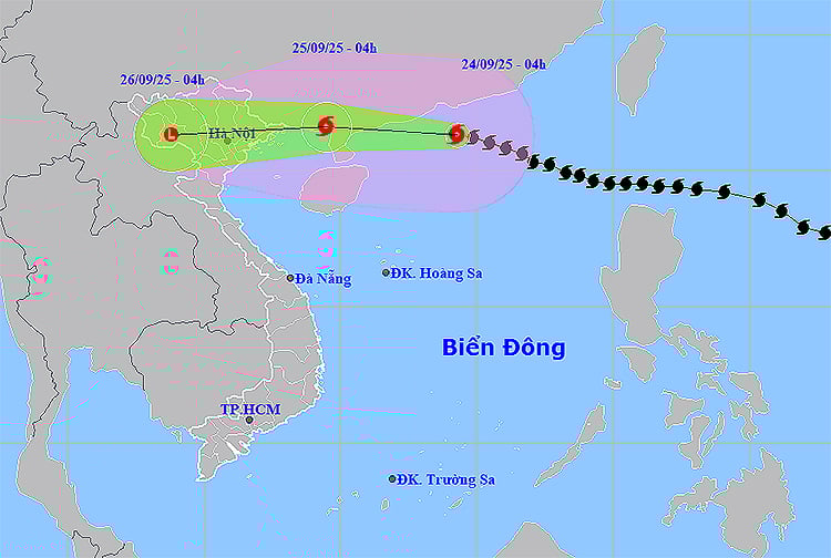
The strongest wind near the storm center is level 15-16 (167-201 km/h), gusting over level 17. The super typhoon moves in a West-Northwest direction at a speed of about 20 km/h.
It is forecasted that by 4am on September 25, the eye of the storm will be on the coast of Guangxi province (China), about 150km east of Mong Cai, the wind speed will decrease to level 11, gusting to level 13 and continue to weaken. By the morning of September 26, the storm will move deep into the Northwest region, weaken into a tropical depression and gradually dissipate.
In the northern sea area of the North East Sea, strong winds of level 10-13, near the storm center strong winds of level 14-16, gusts over level 17, waves over 10 m high, rough seas. From noon on September 24, the northeastern sea area of the Gulf of Tonkin, including Bach Long Vy, has winds gradually increasing to level 6-7, gusts of level 9.
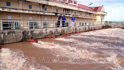
On the night of September 24, in the northern part of the Gulf of Tonkin, including Van Don, Co To, Cat Hai and Hon Dau, strong winds of level 8, later increasing to level 9-11, gusting to level 13; waves 3-5 m high, very rough seas. The coastal area of Quang Ninh - Hai Phong is forecast to have a water level rise of 0.4-0.6 m, with a high risk of causing landslides of dikes, seawalls, destroying aquaculture areas and vehicles moored along the shore.
On September 24, the North will have scattered showers and thunderstorms, which will increase rapidly from nightfall, with heavy to very heavy rain in many places. From the night of September 24 to the end of September 26, the North, Thanh Hoa and Nghe An will have heavy to very heavy rain, with rainfall ranging from 100-250 mm in general, and over 400 mm in some places.
The area from Thanh Hoa to Quang Ngai has showers and thunderstorms, locally heavy rain. The Central Highlands and Southeast continue to have moderate to heavy rain, with some places experiencing very heavy rain.
From early morning of September 25, the coast from Quang Ninh to Ninh Binh has strong winds of level 6-7, near the storm center of level 8-9, gusting to level 11. Inland in the Northeast, winds of level 5-6, gusting to level 7-8.
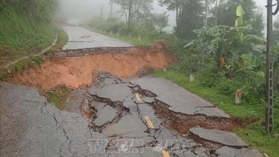
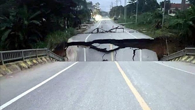
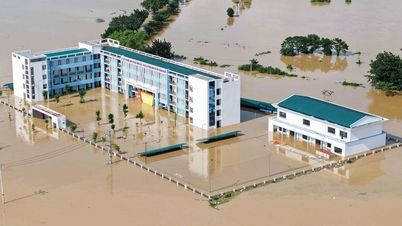
Risk of flash floods, landslides in mountainous areas, flooding in urban areas, low-lying areas. Thunderstorms may be accompanied by tornadoes, lightning, hail and strong gusts of wind.
Meteorological agencies recommend that local authorities and people in affected areas closely monitor storm developments, proactively prepare response plans, and ensure safety of life and property.
Weather forecast for regions across the country:
Hanoi capital is cloudy, sunny during the day, with showers and scattered thunderstorms at night, with some places experiencing heavy to very heavy rain. North to northwest wind level 2-3. Lowest temperature 24-26 degrees Celsius. Highest temperature 33-35 degrees Celsius.
The Northwestern provinces are cloudy, sunny during the day, with showers and thunderstorms in some places in the evening and at night. Light wind. During thunderstorms, there is a possibility of tornadoes, lightning and strong gusts of wind. The lowest temperature is 22-25 degrees Celsius, in some places below 21 degrees Celsius. The highest temperature is 32-35 degrees Celsius.
The Northeastern region is cloudy, sunny during the day; moderate rain, heavy rain and scattered thunderstorms at night, locally very heavy rain. North to northwest wind level 2-3. During thunderstorms, there is a possibility of tornadoes, lightning and strong gusts. The lowest temperature is 22-25 degrees Celsius, in mountainous areas, some places below 22 degrees Celsius. The highest temperature is 32-35 degrees Celsius.
Provinces from Thanh Hoa to Hue will be cloudy, sunny during the day, with showers and thunderstorms in some places in the evening and at night. North to northwest winds at level 2-3. During thunderstorms, there is a possibility of tornadoes, lightning, hail and strong gusts of wind. Lowest temperature 24-27 degrees Celsius. Highest temperature 31-34 degrees Celsius.
The South Central Coast region is cloudy, sunny during the day, with showers and thunderstorms in some places in the evening and at night. West to southwest wind level 2-3. During thunderstorms, there is a possibility of tornadoes, lightning, hail and strong gusts of wind. Lowest temperature 24-27 degrees Celsius. Highest temperature 31-34 degrees Celsius.
Central Highlands cloudy, scattered showers and thunderstorms, scattered showers and thunderstorms in the evening and at night, locally heavy rain. Southwest wind level 2-3. Thunderstorms are likely to cause tornadoes, lightning, hail and strong gusts of wind. Lowest temperature 19-22 degrees Celsius. Highest temperature 25-28 degrees Celsius.
The South is cloudy with scattered showers and thunderstorms; in the late afternoon and evening there are scattered showers and thunderstorms. In the East, there are scattered showers and thunderstorms in the late afternoon and at night, with some places having heavy rain. Southwest wind level 3. During thunderstorms, there is a possibility of tornadoes, lightning, hail and strong gusts of wind. Lowest temperature 23-26 degrees Celsius. Highest temperature 30-33 degrees Celsius.
Ho Chi Minh City is cloudy, with scattered showers and thunderstorms in the late afternoon and at night, with heavy rain in some places. Southwest wind level 3. Thunderstorms are likely to produce tornadoes, lightning, hail and strong gusts of wind. Lowest temperature 24-26 degrees Celsius. Highest temperature 31-33 degrees Celsius.
Source: https://baotintuc.vn/xa-hoi/thoi-weather-ngay-249-sieu-bao-tien-vao-bac-bien-dong-canh-bao-mua-lon-va-gio-giat-manh-20250924060158957.htm


![[Photo] Binh Trieu 1 Bridge has been completed, raised by 1.1m, and will open to traffic at the end of November.](https://vphoto.vietnam.vn/thumb/1200x675/vietnam/resource/IMAGE/2025/10/2/a6549e2a3b5848a1ba76a1ded6141fae)


Comment (0)