
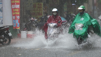
Sun protection clothing and face masks are indispensable items for people when participating in traffic. (Photo: Vu Quang/VNA)

According to the National Center for Hydro-Meteorological Forecasting, on the day and night of September 4, the Northern provinces will continue to be hot and sunny, while the Central, Central Highlands and Southern regions will have showers and thunderstorms, with some places experiencing heavy to very heavy rain.
Weather in specific areas is as follows:
Hanoi capital
- Cloudy, hot during the day; showers and thunderstorms in some places in the evening and at night. Light wind.
- Lowest temperature from 26-28 degrees Celsius, highest from 34-36 degrees Celsius.
Northwest region
- Cloudy, sunny during the day, hot in some places; showers and thunderstorms in some places in the evening and at night. Light wind.
- Lowest temperature from 24-27 degrees Celsius, some places below 23 degrees Celsius; highest temperature from 32-35 degrees Celsius, some places above 35 degrees Celsius.
Northeastern region
- Cloudy, sunny during the day, hot in some places; showers and thunderstorms in some places in the evening and at night. Light wind.
- Lowest temperature from 25-28 degrees Celsius, in mountainous areas below 24 degrees Celsius; highest from 32-35 degrees Celsius, in some places above 35 degrees Celsius.
Area from Thanh Hoa - Hue
- Cloudy, scattered showers and thunderstorms, especially in the South in the late afternoon and evening with scattered showers and thunderstorms. Light wind. Thunderstorms may cause tornadoes, lightning and strong gusts of wind.
- Lowest temperature from 24-27 degrees Celsius, highest from 31-34 degrees Celsius, some places above 34 degrees Celsius.
South Central Coast Region
- Cloudy with scattered showers and thunderstorms, locally heavy rain. Light wind in the North, Southwest wind level 2-3 in the South. Thunderstorms may cause tornadoes, lightning and strong gusts of wind.
- Lowest temperature from 24-27 degrees Celsius, highest from 30-33 degrees Celsius, some places above 33 degrees Celsius.
Central Highlands region
- Cloudy, scattered showers and thunderstorms; scattered showers and thunderstorms in the afternoon and at night, with heavy rain in some places. Southwest wind level 2-3. Thunderstorms may cause tornadoes, lightning and strong gusts of wind.
- Lowest temperature from 20-23 degrees Celsius, highest from 28-31 degrees Celsius.
Southern Vietnam
- Cloudy, scattered showers and thunderstorms; scattered showers and thunderstorms in the afternoon and evening, with heavy rain in some places. Southwest wind level 2-3. Thunderstorms may cause tornadoes, lightning, hail and strong gusts of wind.
- Lowest temperature from 23-26 degrees Celsius, highest from 30-33 degrees Celsius, some places above 33 degrees Celsius.
Ho Chi Minh City
- Cloudy, scattered showers and thunderstorms; scattered showers and thunderstorms in the afternoon and evening, locally heavy to very heavy rain in some places. Southwest wind level 2-3. Thunderstorms may cause tornadoes, lightning, hail and strong gusts of wind.
- Lowest temperature from 25-27 degrees Celsius, highest from 31-33 degrees Celsius, some places above 33 degrees Celsius.
Marine weather
According to the National Center for Hydro-Meteorological Forecasting, currently, the tropical convergence zone has an axis at about 14-17 degrees North latitude connecting with the low pressure area in the central East Sea.
At 1:00 a.m., the low pressure area was identified at about 15.5-16.5 degrees North latitude, 111.5-112.5 degrees East longitude.
The sea area from Da Nang to Ca Mau, from Ca Mau to An Giang, the Gulf of Thailand, the eastern sea area of the North East Sea and the central East Sea area will have scattered showers and thunderstorms.
It is forecasted that during the day and night of September 4, the above-mentioned areas, including the sea from Da Nang-Ca Mau, Ca Mau-An Giang, the Gulf of Thailand, the eastern sea of the North East Sea, the central and southern East Sea (including the Truong Sa archipelago), will continue to have scattered showers and thunderstorms.
Warning, in thunderstorms there is a possibility of tornadoes, strong gusts of wind level 6-7 and waves over 2m high.
Vessel operations in the above areas are at risk of being affected by cyclones at sea, strong gusts of wind and large waves.
Localities and fishermen need to closely monitor weather developments to proactively take safety measures./.
According to Vietnamplus
Source: https://www.vietnamplus.vn/thoi-tiet-ngay-49-bac-bo-nang-nong-cuc-bo-nguy-co-mua-lon-tai-phia-nam-post1059733.vnp
Source: https://baolongan.vn/thoi-weather-ngay-4-9-bac-bo-nang-nong-cuc-bo-nguy-co-mua-lon-tai-phia-nam-a201877.html
![[Photo] Students of Binh Minh Primary School enjoy the full moon festival, receiving the joys of childhood](https://vphoto.vietnam.vn/thumb/1200x675/vietnam/resource/IMAGE/2025/10/3/8cf8abef22fe4471be400a818912cb85)


![[Photo] Prime Minister Pham Minh Chinh chairs meeting to deploy overcoming consequences of storm No. 10](https://vphoto.vietnam.vn/thumb/1200x675/vietnam/resource/IMAGE/2025/10/3/544f420dcc844463898fcbef46247d16)


Comment (0)