
Central Highlands locally has rain over 100 mm
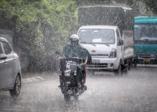
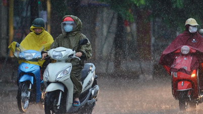
The National Center for Hydro-Meteorological Forecasting informed that in the evening and night of September 22, the Northern region and Thanh Hoa will have scattered showers and thunderstorms with rainfall of 10-30 mm, locally heavy rain over 70 mm. The Central Highlands region will have rain, moderate rain and scattered thunderstorms with rainfall of 20-40 mm, locally heavy rain over 100 mm. The Southern region will have scattered showers and thunderstorms with rainfall of 15-30 mm, locally heavy rain over 80 mm.
In the afternoon and evening of September 22, the South Central Coast will have showers and scattered thunderstorms with rainfall from 15-30 mm, with some places having heavy rain over 80 mm.
Warning of risk of heavy rain over 70 mm in 3 hours.
"Thunderstorms are likely to cause tornadoes, lightning, hail and strong gusts of wind. Localized heavy rains can cause flash floods on small rivers and streams, landslides on steep slopes and flooding in low-lying areas," noted Deputy Head of the Weather Forecasting Department Le Thi Loan.
On September 22, the Northern region, Central Highlands and Southern region will have showers and thunderstorms, with some places having heavy rain. The rainfall from 7am to 3pm on September 22 was over 60mm in some places such as: Nhat Hoa station (Lang Son) 73.9mm, Buon Triet station (Dak Lak) 62.8mm, So Sao ( Ho Chi Minh City) 61.2mm,...
Beware of flash floods and landslides in Khanh Hoa province
The National Center for Hydro-Meteorological Forecasting said that from 5:20 p.m. to 10:20 p.m. on September 22, Khanh Hoa province will continue to have rain with accumulated rainfall ranging from 15-30 mm, with some places over 50 mm.
Risk warning: flash floods on small rivers and streams, landslides on steep slopes in the above province, especially in the communes/wards: Nam Cam Ranh, Do Vinh, Thuan Bac; Bac Ai Dong, Bac Ai Tay, Cam An, Cam Lam, Cong Hai, Dong Khanh Son, Lam Son, Ward Bac Cam Ranh, Tay Khanh Son.
Level of natural disaster risk due to flash floods, landslides, land subsidence due to rain, floods or water flow: Level 1.
Flash floods and landslides can have very negative impacts on the environment, threaten people's lives; cause local traffic congestion, affect the movement of vehicles; destroy civil and economic works, causing damage to production and socio-economic activities.
The hydrometeorological agency recommends that local authorities pay attention to reviewing bottlenecks and vulnerable locations in the area to have prevention and response measures.
From 2:00 p.m. to 4:00 p.m. on September 22, Khanh Hoa province had moderate and heavy rain such as: Thanh Son 69.3 mm, Thanh Son 3 63.2 mm, Phuoc Thanh 53.6 mm,...
Soil moisture models show that some areas in the province are near saturation (over 85%) or have reached saturation.
Tornadoes and strong winds in many coastal areas
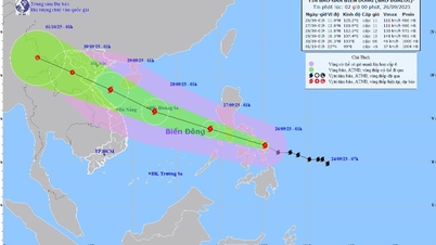
At sea, the National Center for Hydro-Meteorological Forecasting forecasts that on the night of September 22 and September 23, in the southern part of the North East Sea (including Hoang Sa special zone), there will be strong winds of level 6-7, then increasing to level 7, sometimes level 8, gusting to level 9-10, rough seas, waves 3-5m high.
In the central East Sea, strong winds level 6-7, gusts level 9, rough seas, waves 3-5m high.
The sea area from Khanh Hoa to Ho Chi Minh City and the South East Sea area (including Truong Sa special zone) has strong winds of level 6, sometimes level 7 during the day, gusting to level 8-9, rough seas, waves 3-5m high.
In addition, on the night of September 22 and September 23, the North East Sea (including Hoang Sa special zone) will have storms. The Central and South East Sea (including Truong Sa special zone), Bac Bo Gulf, the sea from South Quang Tri to Ca Mau, Ca Mau to An Giang will have scattered showers and thunderstorms. During the thunderstorms, there is a possibility of tornadoes, strong gusts of wind of level 6-7 and waves over 2m high.
Warning: on the night of September 23 and on September 24, the northern sea area of the North East Sea will have strong winds of level 11-14, near the eye of the storm will have winds of level 15-17, gusts above level 17 and stormy rain; waves 6-8m high, near the eye of the storm over 10m; rough seas.
The sea area south of the North East Sea (including Hoang Sa special zone), the central East Sea area has strong southwest to south wind at level 6-7, sometimes level 8, gusting to level 9-10; waves 3-5m high, rough seas.
The sea area from Khanh Hoa to Ho Chi Minh City and the South East Sea area (including Truong Sa special zone) has strong southwest wind level 6, sometimes level 7, gusting to level 9; waves 3-5m high, rough seas.
On September 24, the wind in the Gulf of Tonkin gradually increased to level 6-7, waves 2-4m high, and rough seas.
Risk level of natural disasters due to strong winds at sea: level 2; coastal areas from Khanh Hoa to Ho Chi Minh City level 3, northern sea areas of the North East Sea level 4.
All vessels operating in the above areas are at high risk of being affected by cyclones, strong winds and large waves.
Weather in different regions on the night of September 22 and September 23
In the Northwest, there will be scattered showers and thunderstorms at night and in the morning, with some places having heavy rain. During thunderstorms, there is a possibility of tornadoes, lightning and strong gusts of wind; sunny during the day. Light wind. Lowest temperature 22-25 degrees Celsius, some places below 22 degrees Celsius. Highest temperature 31-34 degrees Celsius, some places above 34 degrees Celsius.
In the Northeast, there will be scattered showers and thunderstorms at night and in the morning, with some places having heavy rain. During thunderstorms, there is a possibility of tornadoes, lightning and strong gusts of wind; sunny during the day. Light wind. Lowest temperature 23-26 degrees Celsius, in mountainous areas, some places below 22 degrees Celsius. Highest temperature 31-34 degrees Celsius, some places above 34 degrees Celsius.
Hanoi city at night and early morning sometimes has showers and thunderstorms, in thunderstorms there is a possibility of tornadoes, lightning, hail and strong gusts of wind; sunny day. Light wind. Lowest temperature 24-26 degrees Celsius. Highest temperature 32-34 degrees Celsius, some places above 34 degrees Celsius.
Provinces and cities from Thanh Hoa to Hue will have scattered showers and thunderstorms; tomorrow evening there will be scattered showers and thunderstorms, locally heavy rain, with the possibility of tornadoes, lightning, hail and strong gusts of wind.
Lowest temperature 23-26 degrees Celsius. Highest temperature 31-34 degrees Celsius, some places above 34 degrees Celsius.
The South Central Coast has scattered showers and thunderstorms; in the late afternoon and evening, there will be scattered showers and thunderstorms, locally heavy rain, with the possibility of tornadoes, lightning, hail and strong gusts of wind. The lowest temperature is 23-26 degrees Celsius. The highest temperature is 31-34 degrees Celsius, some places above 34 degrees Celsius.
Central Highlands has rain at night, moderate rain and scattered thunderstorms, locally heavy to very heavy rain; during the day there are scattered showers and thunderstorms, locally heavy rain, with the possibility of tornadoes, lightning, hail and strong gusts of wind. Southwest wind level 2-3. Lowest temperature 20-23 degrees Celsius. Highest temperature 27-30 degrees Celsius.
The Southern region has scattered showers and thunderstorms, some places have heavy rain, in thunderstorms there is a possibility of tornadoes, lightning, hail and strong gusts of wind. Southwest wind level 2-3. Lowest temperature 24-27 degrees Celsius. Highest temperature 29-32 degrees Celsius, some places above 32 degrees Celsius.
Ho Chi Minh City has scattered showers and thunderstorms, some places have heavy rain, thunderstorms have the possibility of tornadoes, lightning, hail and strong gusts of wind. Southwest wind level 2-3. Lowest temperature 24-26 degrees Celsius. Highest temperature 29-31 degrees Celsius.
Source: https://baotintuc.vn/xa-hoi/thoi-tiet-dem-229-canh-bao-nguy-co-mua-cuong-suat-lon-o-nhieu-khu-vuc-20250922180624836.htm
![[Photo] Prime Minister Pham Minh Chinh attends the groundbreaking ceremony of two key projects in Hai Phong city](https://vphoto.vietnam.vn/thumb/1200x675/vietnam/resource/IMAGE/2025/9/27/6adba56d5d94403093a074ac6496ec9d)


Comment (0)