
The National Center for Hydro-Meteorological Forecasting said that from around the end of September, the North will welcome the first cold air waves of this winter. These are weak cold air waves, often causing thunderstorms and a slight drop in temperature, bringing the typical chilly autumn weather in the North.
This year’s cold front has arrived early. The impact of the air in a stormy year could cause complicated floods in the Central region at the end of the year. From now until early October, there is a possibility of about 2 storms/tropical depressions appearing in the East Sea, one of which could affect our mainland.

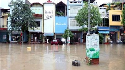
Storms, tropical depressions and southwest monsoons cause strong winds, large waves at sea and affect shipping activities. In particular, beware of heavy rains that can cause flooding, inundation in low-lying areas and landslides in mountainous areas.
"Heavy rain, thunderstorms, tornadoes and lightning can negatively affect production activities and public health," the National Center for Hydro-Meteorological Forecasting warned.
The East Sea is experiencing a year of many storms. From August 11 to September 10 alone, there have been 3 storms and tropical depressions in the East Sea. Of which, storm No. 5 and storm No. 6 both made landfall in the North Central region of our country, causing strong gusts of wind and widespread heavy rain. Tropical depression and storm No. 7, although not making landfall in our country, caused heavy rain in the Northern region.
Central region may experience historic heavy rain
It is forecasted that from now until early October, the Northern Delta region and provinces from Thanh Hoa to Quang Ngai are likely to experience some widespread heavy rains, interspersed with mild hot days.
The Southern region and other places in the Central region also have many showers and thunderstorms during this time, in which, some days there may be moderate rain, heavy rain. Rain time is mainly concentrated in the late afternoon and evening.
Mr. Nguyen Van Huong, Head of Weather Forecasting Department, National Center for Hydro-Meteorological Forecasting, said that from now until the end of the year, the number of storms and tropical depressions is forecast to be higher than the average of many years. There will be about 6-8 storms or tropical depressions in the East Sea and half of these storms are likely to affect our mainland.
"From now until October, the provinces from Thanh Hoa to Hue will be the focus of storms or tropical depressions. From the second half of October to November, from Hue to the South Central Coast, as well as the Southern region, will be the focus.
"We need to be on guard against storms and tropical depressions forming right in the East Sea, which will shorten the response time," Mr. Huong noted.
According to Mr. Huong, from now until the end of November, the Central region is likely to have total rainfall 10-30% higher than the average of many years.
"In case a storm or tropical depression impacts the Central region combined with easterly winds and cold air, there is a possibility of exceptionally heavy rain. This is what the National Center for Hydro-Meteorological Forecasting is concerned about, the possibility of historic floods in the Central region in the coming time," Mr. Huong said.
Due to the influence of storms and strong tropical depressions, the North and North Central regions have experienced heavy rains in recent times with many records being recorded. In particular, the rain in Hanoi on August 26 due to the influence of storm No. 5 was the heaviest daily rain recorded in the capital, surpassing the record set 53 years ago. Thanh Hoa, Ninh Binh, Tuyen Quang, Ho Chi Minh City, Phu Tho, and Da Nang also recorded record daily rainfall in August history.
Source: https://baolaocai.vn/tu-nay-den-thang-10-bien-dong-co-the-co-2-con-bao-mien-trung-mua-lon-lich-su-post881885.html


Comment (0)