
Commenting on the developments of storm No. 10, Associate Professor, Doctor, Director of the National Center for Hydro-Meteorological Forecasting Mai Van Khiem said that due to the storm's influence, the northern area of the Gulf of Tonkin has strong winds, very rough seas and is very dangerous for the safety of ships.
It is forecast that by 1 p.m. on September 29, the storm in the Upper Laos region with wind speed of level 7, gusting to level 9; will make landfall in Thanh Hoa - Northern Quang Tri provinces and gradually weaken into a tropical depression.
Due to the influence of storm No. 10, at Ly Son station (Quang Ngai), there were strong winds of level 7, gusts of level 8; Bac Trach station (Quang Tri) had strong winds of level 8, gusts of level 10; Hoanh Son station ( Ha Tinh ) had strong winds of level 6, gusts of level 9; Van Ly station (Ninh Binh) had strong winds of level 7, gusts of level 9; Hon Ngu station (Nghe An) had strong winds of level 6, gusts of level 8; Con Co station (Quang Tri) had strong winds of level 7, gusts of level 10; Bach Long Vi station had strong winds of level 7, gusts of level 9...
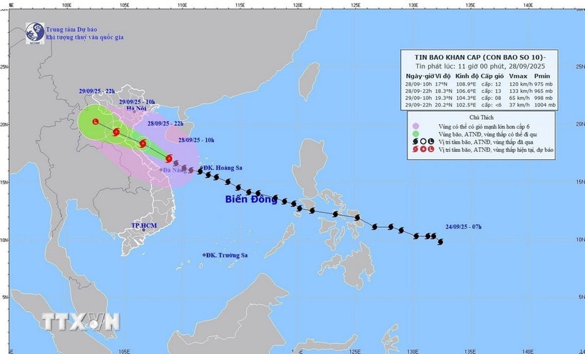
According to the National Center for Hydro-Meteorological Forecasting, at 1:00 p.m. on September 28, the center of the storm was located at about 17.1 degrees North latitude; 108.3 degrees East longitude, on the sea area of Quang Tri - Da Nang city, about 90km East Northeast of Hue city, about 190km South Southeast of North Quang Tri. The strongest wind near the center of the storm was level 12 (118-133km/h), gusting to level 15. Moving in the West Northwest direction at a speed of about 25km/h.
This is a fast-moving storm with strong intensity and wide range of influence, which can cause combined impacts of many types of natural disasters such as strong winds, heavy rains, floods, flash floods, landslides and coastal flooding.
Forecast until 1:00 a.m. on September 29, the storm is on the sea area of Nghe An - North Quang Tri with strong wind force of 12, gust level 15; moving in the West Northwest direction at about 20-25 km/h.
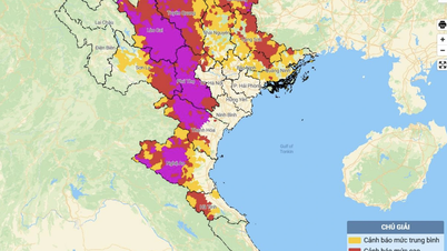
The affected areas are the western sea area of the North East Sea; the sea area from Thanh Hoa to Da Nang city (including Hon Ngu island, Con Co special economic zone); the northern Gulf of Tonkin (including Bach Long Vi special economic zone, Van Don, Co To, Cat Hai and Hon Dau island) with risk level 3; the coastal mainland area from Nghe An to the north of Quang Tri with risk level 4.
At 1 p.m. on September 29, the storm in the Upper Laos region with wind speed of level 7, gusting to level 9; moving in the West Northwest direction at a speed of about 20-25 km/h and entering the mainland of Thanh Hoa - Northern Quang Tri provinces and gradually weakening into a tropical depression.
The affected area is the sea from Thanh Hoa to Hue (including Hon Ngu island, Con Co special zone). Northern Gulf of Tonkin (including Bach Long Vi special zone, Van Don, Co To, Cat Hai and Hon Dau island). Risk level 3.
At 1:00 a.m. on September 30, the storm in the Upper Laos region with winds below level 6, moving in the West Northwest direction at about 20-25 km/h, continued to weaken into a low pressure area.
Due to the influence of the storm, the western sea area of the North East Sea has strong winds of level 6-8, waves of 4-6m high, and rough seas.
The sea area from Thanh Hoa to Quang Ngai (including Hon Ngu island, Con Co special zone and Ly Son) has strong winds of level 8-10, the area near the storm's eye has winds of level 11-12, gusts of level 15, waves of 6-8m high, very rough seas (extremely destructive, extremely strong waves. Sinking large tonnage ships).
The Northern Gulf of Tonkin area (including Bach Long Vi, Van Don, Co To, Cat Hai and Hon Dau islands) has strong winds of level 6-7, then increasing to level 8-9 (very rough seas, very dangerous for boats), gusts of level 11, waves 3-5m high, very rough seas.
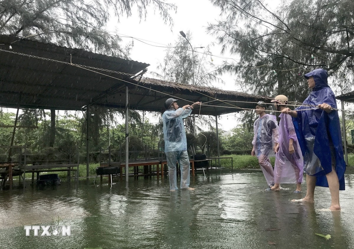
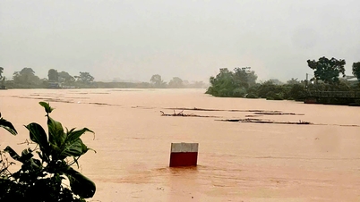
Coastal areas and islands from Hung Yen to Ha Tinh have storm surges of 0.5-1.5m, and Thanh Hoa and Nghe An have 1-1.5m. There is a high risk of flooding on the morning of September 29 in low-lying areas, coastal roads, and river mouths due to storm surges, waves, and rain.
Weather warning at sea and coastal areas during storms is extremely dangerous, unsafe for any vehicle or structure operating in dangerous areas such as: cruise ships, passenger ships, transport ships, cages, rafts, aquaculture areas, dykes, embankments, coastal routes.
Vehicles are at high risk of capsizing and destruction; flooding due to strong winds, large waves and rising sea levels.
On land, the area from South Quang Tri to Hue city has strong winds of level 6-7 (trees shaking, difficult to go against the wind), gusts of level 8-9.
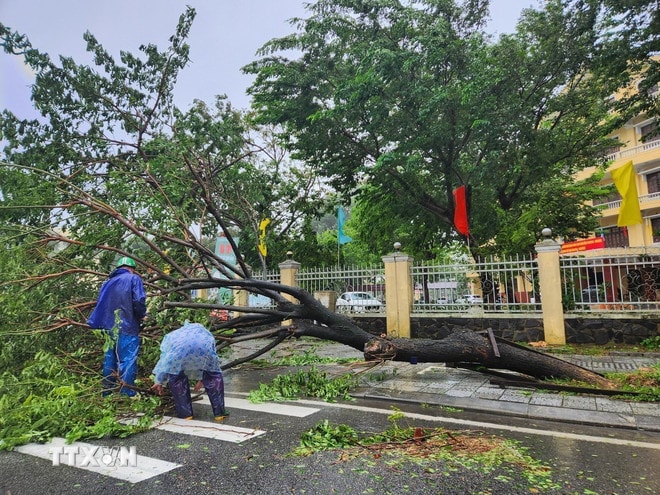
In the area from Thanh Hoa to Northern Quang Tri, the wind gradually increases to level 6-7, then increases to level 8-9, in the area near the storm center, it is level 10-12 (wind force can knock down trees, houses, electric poles, causing very heavy damage), gusting to level 14.
Coastal areas from Quang Ninh to Ninh Binh have winds gradually increasing to level 6-7, gusting to level 8-9, in some places level 8, gusting to level 10.
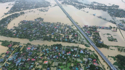
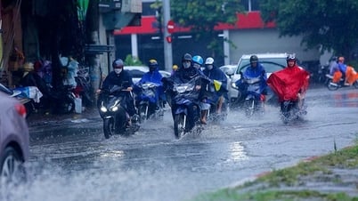
From the afternoon of September 28 to September 30, in the North and the area from Thanh Hoa to Da Nang city, there will be moderate rain, heavy rain, and in some places very heavy rain with total rainfall from 100-300mm, locally over 450mm; in the Northern Delta, Phu Tho, the south of Son La and Lao Cai provinces, from Thanh Hoa to the north of Quang Tri, there will be heavy to very heavy rain with total rainfall from 200-400mm, locally over 600mm. Warning of the risk of heavy rain over 200mm/3 hours./.
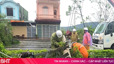
Establishing a frontline command committee in the provinces where the storm is expected to pass through to respond to the storm.
In Official Dispatch No. 174/CD-TTg dated September 27, 2025, Prime Minister Pham Minh Chinh directed the establishment of Forward Steering Committees in provinces where the eye of storm No. 10 (storm BUALOI) passes through; focusing on seriously, resolutely and effectively implementing the work of preventing and combating storm No. 10.
The Prime Minister requested to immediately deploy measures to protect and reinforce dikes and dams, especially sea dikes, river estuaries, and key dams; proactively operate and regulate reservoirs to be ready to receive floods, ensure the safety of dams and reservoirs, and prevent floods from overlapping floods; proactively evacuate people and stockpile food; arrange forces and means to be ready to support people in responding to storms, floods, and support evacuation and relocation of residents, and rescue when required./.
Nghe An and Ha Tinh evacuate people from dangerous areas
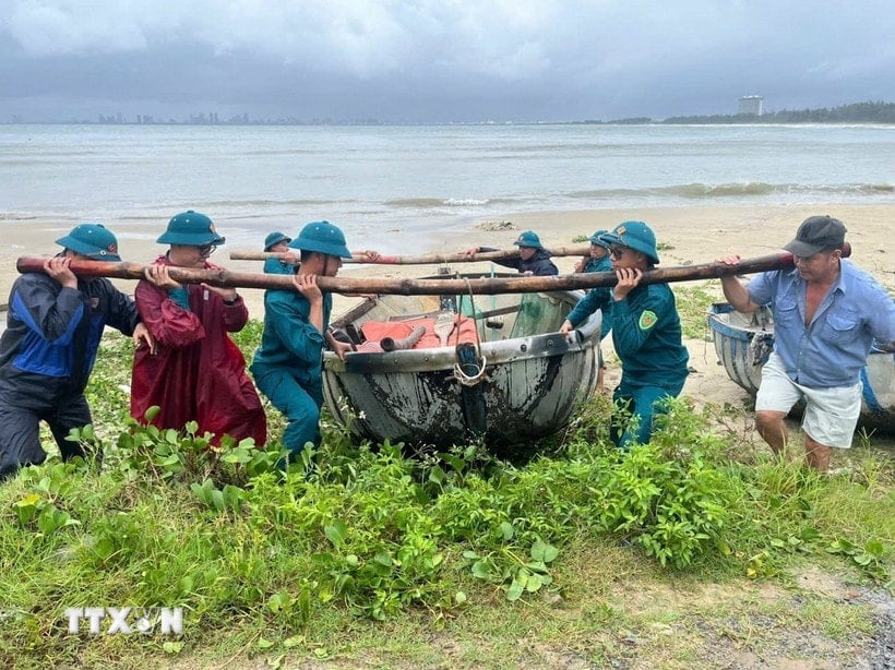
Faced with the complicated developments of storm No. 10, Nghe An and Ha Tinh provinces are urgently implementing response measures, in which evacuating people from dangerous areas is considered a key task.
In Cua Lo ward, Nghe An province, one of the coastal localities directly affected by the storm, the evacuation of people is being urgently implemented.
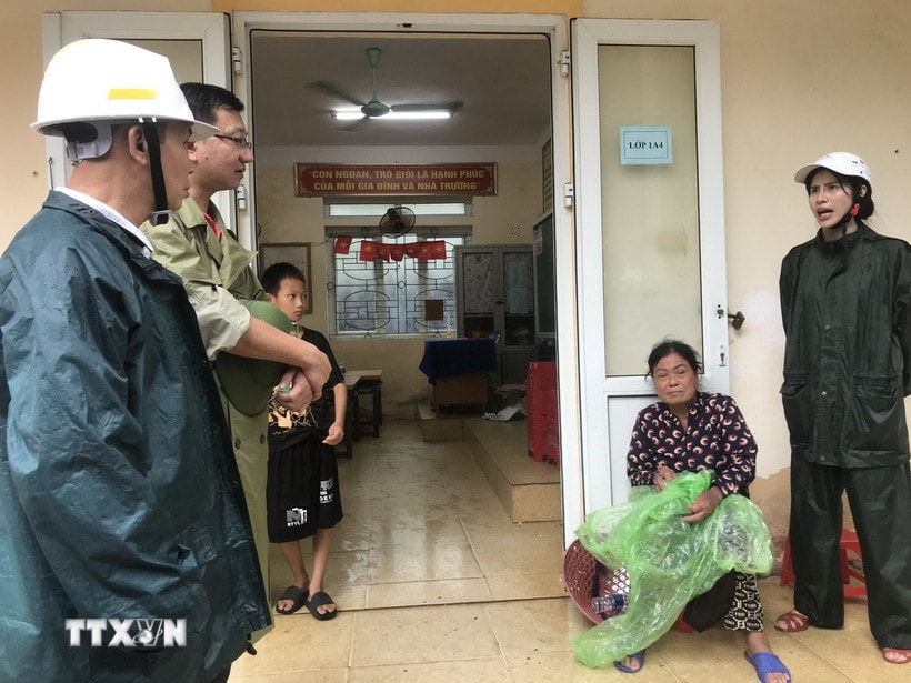
Mr. Nguyen Van Hung - Vice Chairman of the People's Committee of Cua Lo Ward, said that the entire ward has 615 households that need to be evacuated because their houses are in disrepair and at risk of losing their roofs when the storm makes landfall.
Of these, 53 households were taken to concentrated shelters such as schools and cultural houses. The remaining households were temporarily housed in solid houses in the area to ensure safety before the storm.
The evacuation is carried out on the principle of prioritizing the elderly, children and households in difficult circumstances. Local authorities closely coordinate with the police, military and mass organizations to support transportation, arrange temporary accommodation, and ensure essential living conditions for people during the evacuation period.
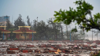
In coastal areas, sea waves rose high, in some areas such as Quynh Phu commune, sea water began to overflow the dike roof, directly threatening coastal residential areas.
Faced with that situation, local authorities have assigned forces to be on duty 24/7, ready to deploy additional evacuation plans if a bad situation occurs.
Restaurants, hotels, and houses along the coast have also proactively reinforced their doors and used sandbags in front of their basements to prevent seawater from flooding in and damaging property.
Colonel Dinh Viet Dung - Director of Nghe An Provincial Police, directed the entire force to deploy a storm prevention plan according to the motto "4 on-site, 3 ready" and the action slogan "When people need, when people are in trouble, there is the police."

Commune and ward police units maintain 100% of their personnel, coordinate with military forces, border guards and local authorities to support the evacuation of people, especially in areas at risk of flooding, landslides and flash floods.
To ensure absolute safety, the Department of Education and Training of Nghe An province has decided to let all students stay home from school on September 29. Schools have also been requisitioned as shelters for displaced people, with the support of armed forces in ensuring security and logistics.
On the same morning, an inspection delegation from the Ministry of National Defense led by Senior Lieutenant General Huynh Chien Thang - Deputy Chief of the General Staff of the Vietnam People's Army inspected the response in Nghe An.
He praised the proactive and flexible spirit of the local army and people, and asked units to continue reviewing and adjusting response plans, and fully preparing forces, means, food and provisions to be ready to support people in emergency situations.
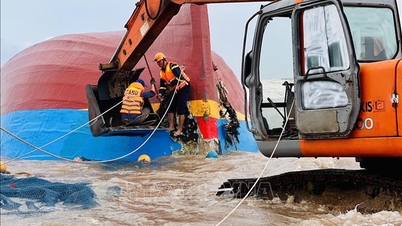
Up to now, agencies and units of Military Region 4 and Nghe An province have deployed synchronous measures to respond to storm No. 10. Adhering to the "4 on-site" motto helps localities to be proactive in all situations, especially in evacuating people from dangerous areas.
In Ha Tinh, on the morning of September 28, localities in coastal areas and areas at high risk of landslides and flash floods urgently used all measures to evacuate people to safety.
Thousands of people in coastal areas and areas at high risk of landslides and flash floods in Ha Tinh were evacuated to safety by local authorities and functional forces before storm No. 10 made landfall.
In Thien Cam commune, there are 800 households with over 1,746 people at risk of being affected when the storm makes landfall. People are being evacuated to families with solid houses, Cam Nhuong kindergarten, and Song Yen church.
In Song Tri ward, 1,000 people in Hai Phong 1, Hai Phong 2 and Hai Thanh residential groups were evacuated to the Medical Station and the old People's Committee headquarters in the ward to ensure safety.
On September 28, the People's Committee of Ha Tinh province also issued an urgent dispatch on focusing on responding to storm No. 10 and floods, landslides, flash floods, and landslides.
The telegram clearly states: absolutely do not let people stay in key areas with high risk of insecurity (Chairmen of People's Committees of communes and wards are responsible to the Provincial People's Committee and the Chairman of the Provincial People's Committee for the evacuation of people in the localities under their management).
At the same time, immediately check locations at risk of landslides, flash floods, landslides, deep flooded areas, high tides, on boats, rafts, and aquaculture huts to organize the evacuation of people to safe places; proactively arrange guards and patrols to ensure security and order at the evacuation sites, not allowing people to return without ensuring safety.
The dispatch of the People's Committee of Ha Tinh province also requested localities in the province to proactively arrange forces, materials and means in key areas to be ready to respond, rescue and salvage when situations arise; reserve food, provisions and necessities in residential areas that are prone to isolation due to floods and landslides, and limit food shortages when storms and floods cause prolonged isolation.
Also on September 28, the Department of Education and Training of Ha Tinh issued an official dispatch requesting localities and educational institutions to allow students of all levels in the province to take a day off on September 29. Depending on the developments of storms, floods and the actual situation in localities, educational institutions can consider extending the school break for students to an appropriate time to ensure safety.
Standing Secretariat directs response to storm No. 10
On September 28, 2025, the Central Party Office issued Official Dispatch No. 17940-CV/VPTW on responding to storm No. 10 (Bualoi) to Provincial Party Committees, Municipal Party Committees, Party Committees directly under the Central Party Committee; Central Party Committees; Party Committees of ministries, branches, socio-political organizations at the Central level; Party Committees of central public service units; and comrades of the Central Party Executive Committee.
The dispatch stated: According to the report of the National Center for Hydro-Meteorological Forecasting, on the morning of September 28, storm No. 10 (Bualoi) in the coastal area of Quang Tri - Da Nang city, about 170km east of Hue city, the strongest wind near the storm center is level 12 (118-133 km/h), gusting to level 15.
The storm moves in the West-Northwest direction at a speed of 30 km/h, making landfall, causing strong winds of level 11-12, gusts of level 14, heavy rain from 200-400mm, locally over 600mm, high tides from 1-1.5m, directly affecting the Northern and North Central regions, especially from Thanh Hoa to Da Nang on September 29-30, 2025 and the following days; very high risk of flooding, flash floods, landslides, rockslides; threatening dykes facing the sea, the safety of reservoirs.
Storm No. 10 is very strong, moving rapidly at an unusual speed, with very complex developments, and its range and intensity of influence on sea and land is very wide and dangerous.
In the face of the above situation, the Standing Secretariat directed Party committees, Party organizations, authorities, the Vietnam Fatherland Front and socio-political organizations in affected areas to urgently direct, urge, inspect and proactively respond to storm No. 10 and heavy rain, the risk of flash floods, landslides, rockfalls, flooding, threatening the sea-facing dyke system and reservoirs; ensure the safety of people's lives and property, State assets, and minimize damage. Update the situation daily and send reports to the Central Party Office (before 4:00 p.m. daily).
The Central Party Office shall preside over and coordinate with relevant agencies to monitor and synthesize the situation, and daily report to the Politburo and Secretariat on relevant situations.
PV (synthesis)Source: https://baohaiphong.vn/bao-gio-con-bao-so-10-se-suy-yeu-thanh-ap-thap-nhiet-doi-522016.html
![[Photo] General Secretary To Lam receives US Ambassador to Vietnam Marc Knapper](https://vphoto.vietnam.vn/thumb/1200x675/vietnam/resource/IMAGE/2025/9/29/c8fd0761aa184da7814aee57d87c49b3)
![[Photo] Many streets in Hanoi were flooded due to the effects of storm Bualoi](https://vphoto.vietnam.vn/thumb/1200x675/vietnam/resource/IMAGE/2025/9/29/18b658aa0fa2495c927ade4bbe0096df)
![[Photo] General Secretary To Lam attends the ceremony to celebrate the 80th anniversary of the post and telecommunications sector and the 66th anniversary of the science and technology sector.](https://vphoto.vietnam.vn/thumb/1200x675/vietnam/resource/IMAGE/2025/9/29/8e86b39b8fe44121a2b14a031f4cef46)
![[Photo] National Assembly Chairman Tran Thanh Man chairs the 8th Conference of full-time National Assembly deputies](https://vphoto.vietnam.vn/thumb/1200x675/vietnam/resource/IMAGE/2025/9/29/2c21459bc38d44ffaacd679ab9a0477c)


Comment (0)