
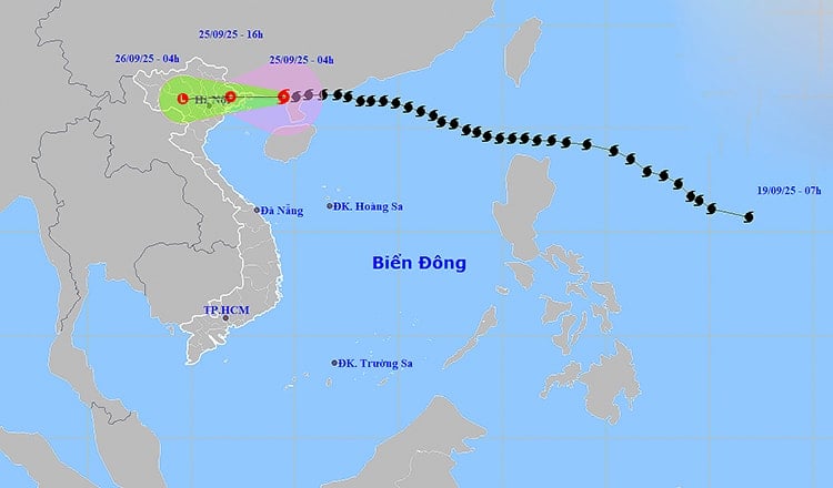
The strongest wind near the storm center is level 9 (75 - 88 km/h), gusting to level 11. The storm is moving west at a speed of about 20 km/h. In Bach Long Vi special zone, there are strong winds of level 7, gusting to level 8.
It is forecast that by 4:00 p.m. on September 25, the center of storm No. 9 will be in the Northeast region of the North, with its intensity decreasing to level 6, gusting to level 8, then continuing to gradually weaken into a tropical depression.
At 4:00 a.m. on September 26, the storm moved to the Northwest region, with an intensity below level 6 and weakened into a low pressure area.
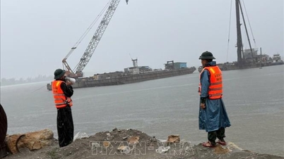
Due to the impact of the storm, the northwest sea area of the North East Sea has strong winds of level 6 - 8, gusts of level 10, waves 3 - 5m high, rough seas. In the North of Bac Bo Gulf (including Bach Long Vi, Van Don, Co To, Cat Hai and Hon Dau), strong winds of level 6 - 7, waves 2 - 3m high; near the center of the storm, strong winds of level 8 - 9, gusts of level 11, waves 3 - 4m high, rough seas. Boats and aquaculture areas in the danger zone are greatly affected by wind, waves and rising water.
On land, coastal areas from Quang Ninh to Hai Phong have winds gradually increasing to level 6 - 7, near the storm center level 8, gusting to level 9 - 10. Inland areas in the Northeast region have strong winds of level 5, in some places level 6, gusting to level 7 - 8.
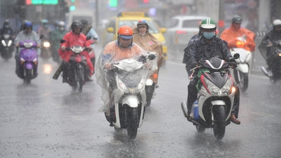
From the morning of September 25 to the end of the night of September 26, in the North, Thanh Hoa and Nghe An there will be heavy to very heavy rain, with rainfall ranging from 150 - 300mm, and over 450mm in some places. Heavy rains are likely to cause flooding in urban areas, especially in Hanoi , Hai Phong, Quang Ninh, Thai Nguyen and Thanh Hoa.
From September 25 to 27, there is a possibility of a flood on rivers in the North, Thanh Hoa, and Nghe An. The flood peak on Thao River and small rivers may reach alert level 2 - 3; Lo River, upper Thai Binh River, Hoang Long, Buoi, upper Ma River reach alert level 1 - 2, some places above alert level 2. There is a high risk of flooding in low-lying areas, flash floods on small rivers and streams, and landslides in mountainous areas.
Source: https://baohaiphong.vn/bao-so-9-tien-vao-dat-lien-bac-bo-gay-mua-lon-dien-rong-521718.html


![[Photo] Soldiers guard the fire and protect the forest](https://vphoto.vietnam.vn/thumb/1200x675/vietnam/resource/IMAGE/2025/9/27/7cab6a2afcf543558a98f4d87e9aaf95)


![[Photo] Prime Minister Pham Minh Chinh attends the 1st Hai Phong City Party Congress](https://vphoto.vietnam.vn/thumb/1200x675/vietnam/resource/IMAGE/2025/9/27/676f179ddf8c4b4c84b4cfc8f28a9550)


Comment (0)