

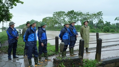
Since this morning (September 9), the mountainous areas of Tuyen Quang, Cao Bang , Thai Nguyen, and Lang Son have had rain. Later in the afternoon, the rain will spread to the Northern Delta, and this period will last until tomorrow night. The heavy rain areas are mainly concentrated in the midlands and mountainous areas, with rainfall ranging from 70 to 150 mm, with some places experiencing very heavy rain of over 300 mm.
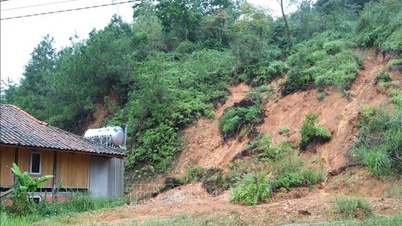
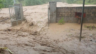
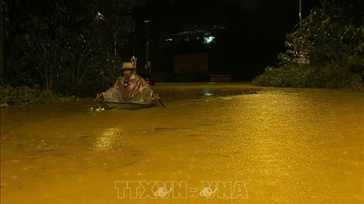
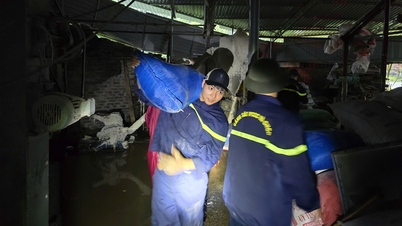
Warning of the risk of heavy rain over 100 mm within 3 hours. Heavy rain is likely to cause flooding in low-lying areas, urban areas; flash floods on small rivers and streams, landslides on steep slopes.
The cause of the rain is due to the circulation after storm No. 7 combined with wind convergence above 5,000 m, accumulating a lot of moisture causing thunderstorms to develop strongly and cause rain. Since September 11, heavy rain in the mountainous and midland areas of the North has gradually decreased.
Due to the rain, the temperature in the North will drop today, the weather will be milder. Temperatures in most wards are generally 28 - 33 degrees Celsius.
In the Central Highlands and the South, this afternoon the rain has decreased compared to previous days, however, there are still some places with quite a lot of rain, with common rainfall of 15 - 30 mm, and in some places over 80 mm.
From morning to noon, this area is still sunny. Wards in the Central Highlands, thanks to the plateau terrain, have moderate temperatures, no place exceeds 30 degrees Celsius. In the South, the weather is hotter, with common temperatures of 31 - 34 degrees Celsius.
In the Central region, this afternoon, most places will be sunny, with thunderstorms occurring in only a few places. The highest temperature in the wards is generally 32 - 34 degrees Celsius, Thanh Sen ward, Ha Tinh province is hot and sunny at 35 degrees Celsius.
At sea, today, Hoang Sa special zone is forecast to have thunderstorms, visibility reduced to below 10 km. Truong Sa special zone has thunderstorms accompanied by tornadoes, strong gusts of wind level 6-7 in thunderstorms.
Weather forecast for regions across the country on September 9:
Hanoi capital is cloudy, with scattered showers and thunderstorms during the day, scattered showers and thunderstorms in the afternoon and at night, with some heavy rain in some places. Light wind. Lowest temperature 25 - 27 degrees Celsius. Highest temperature 31 - 33 degrees Celsius, some places above 33 degrees Celsius.
The Northwestern provinces are cloudy with rain, moderate rain and scattered thunderstorms during the day, moderate rain, heavy rain and scattered thunderstorms in the afternoon and at night, and locally very heavy rain. Light wind. During thunderstorms, there is a possibility of tornadoes, lightning and strong gusts of wind. The lowest temperature is 23 - 26 degrees Celsius, in some places below 22 degrees Celsius. The highest temperature is 30 - 33 degrees Celsius.
The Northeastern region is cloudy, mountainous and midland areas have moderate rain, heavy rain and scattered thunderstorms, locally very heavy rain; other areas are cloudy, with scattered showers and thunderstorms during the day, scattered showers and thunderstorms in the afternoon and at night, locally heavy rain. Light wind. During thunderstorms, there is a possibility of tornadoes, lightning and strong gusts of wind. The lowest temperature is 25 - 27 degrees Celsius, in mountainous and midland areas 23 - 25 degrees Celsius, in some places below 22 degrees Celsius. The highest temperature is 31 - 33 degrees Celsius, in some places above 33 degrees Celsius; in mountainous and midland areas 28 - 31 degrees Celsius.
Provinces from Thanh Hoa to Hue have cloudy weather, sunny during the day, hot in some places; showers and thunderstorms in some places in the afternoon and evening. Southwest wind level 2 - 3. During thunderstorms, there is a possibility of tornadoes, lightning and strong gusts of wind. Lowest temperature 25 - 28 degrees Celsius. Highest temperature 32 - 35 degrees Celsius, some places above 35 degrees Celsius.
The South Central Coast region is cloudy, sunny during the day, scattered showers and thunderstorms in the evening, and showers and thunderstorms in some places at night. Southwest wind level 2 - 3. During thunderstorms, there is a possibility of tornadoes, lightning and strong gusts of wind. Lowest temperature 24 - 27 degrees Celsius. Highest temperature 31 - 34 degrees Celsius, some places above 34 degrees Celsius.
The Central Highlands is cloudy with scattered showers and thunderstorms; in the afternoon and evening there will be scattered showers and thunderstorms, with some heavy rain in some places. Southwest wind level 2-3. During thunderstorms there is a possibility of tornadoes, lightning and strong gusts of wind. Lowest temperature 20-23 degrees Celsius. Highest temperature 27-30 degrees Celsius, some places above 30 degrees Celsius.
The South is cloudy with scattered showers and thunderstorms, with scattered showers and thunderstorms in the afternoon and evening, and heavy rain in some places. Southwest wind level 2-3. There is a possibility of tornadoes, lightning, and strong gusts of wind during thunderstorms. Lowest temperature 23-26 degrees Celsius. Highest temperature 30-33 degrees Celsius.
Ho Chi Minh City is cloudy with scattered showers and thunderstorms, with scattered showers and thunderstorms in the afternoon and evening, and heavy rain in some places. Southwest wind level 2-3. There is a possibility of tornadoes, lightning, and strong gusts of wind during thunderstorms. Lowest temperature 24-26 degrees Celsius. Highest temperature 30-33 degrees Celsius.
Source: https://baolaocai.vn/trung-du-vung-nui-bac-bo-mua-lon-co-noi-tren-300-mm-post881621.html
![[Photo] The 1st Congress of Phu Tho Provincial Party Committee, term 2025-2030](https://vphoto.vietnam.vn/thumb/1200x675/vietnam/resource/IMAGE/2025/9/30/1507da06216649bba8a1ce6251816820)
![[Photo] Solemn opening of the 12th Military Party Congress for the 2025-2030 term](https://vphoto.vietnam.vn/thumb/1200x675/vietnam/resource/IMAGE/2025/9/30/2cd383b3130d41a1a4b5ace0d5eb989d)

![[Photo] Panorama of the cable-stayed bridge, the final bottleneck of the Ben Luc-Long Thanh expressway](https://vphoto.vietnam.vn/thumb/1200x675/vietnam/resource/IMAGE/2025/9/30/391fdf21025541d6b2f092e49a17243f)
![[Photo] President Luong Cuong receives President of the Cuban National Assembly Esteban Lazo Hernandez](https://vphoto.vietnam.vn/thumb/1200x675/vietnam/resource/IMAGE/2025/9/30/4d38932911c24f6ea1936252bd5427fa)
![[Photo] General Secretary To Lam, Secretary of the Central Military Commission attends the 12th Party Congress of the Army](https://vphoto.vietnam.vn/thumb/1200x675/vietnam/resource/IMAGE/2025/9/30/9b63aaa37ddb472ead84e3870a8ae825)


Comment (0)