
On August 21, NISAR's L-band radar captured an image of Mount Desert Island in Maine, USA. Green represents forest, magenta represents hard surfaces such as bare ground and structures.
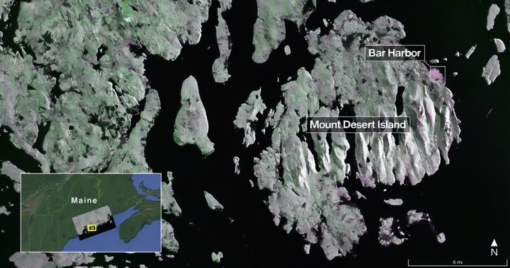
Taken on August 21, 2025, this image from NISAR's L-band radar shows Mount Desert Island in Maine, USA. (Source: NASA)
On August 23, the satellite continued to capture images of the Forest River area in North Dakota, clearly showing flooded forests, farmland and circular irrigation systems.
NISAR provides high-resolution data for disaster monitoring, infrastructure, agricultural management and climate change. The radar system can distinguish between trees, structures and soil moisture, helping to monitor changes in the Earth's surface.
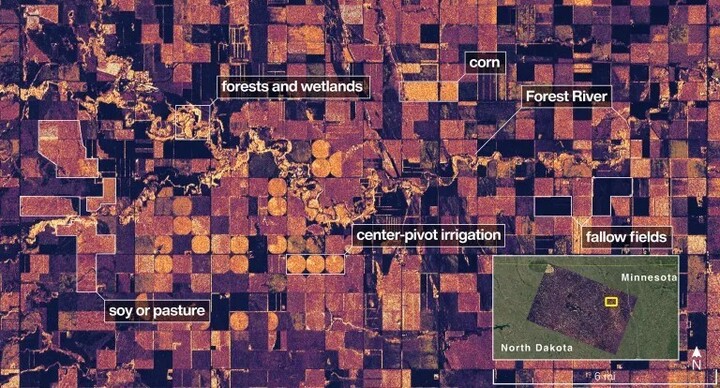
This image shows the Forest River area in North Dakota, USA - the circles and rectangles across the image appear in shades of color that suggest the land could be grassland or farmland. (Source: NASA)
NISAR is the first satellite to carry both L-band (provided by NASA) and S-band (developed by ISRO) radars. L-band radar has a wavelength of 25 cm, penetrates forest canopy and measures ground motion to the millimeter – extremely useful in monitoring earthquakes, volcanoes and landslides.
The satellite was launched by ISRO on July 30 and is currently operating in an orbit of 747 km. NASA JPL is responsible for the L-band radar, data transmission system and data logger. ISRO is responsible for the S-band radar, satellite body and launch services.

The NISAR satellite (illustrative image) will measure physical changes on the Earth's surface as small as one centimeter. (Source: NASA)
NISAR will scan the land and ice surface twice every 12 days, using its 12-meter-wide drum-shaped antenna – the largest ever sent into space by NASA. The data will be transmitted back via NASA’s near-space network.
Source: https://vtcnews.vn/ve-tinh-nisar-he-lo-hinh-anh-radar-dau-tien-cua-trai-dat-ar968018.html
![[Photo] Panorama of the cable-stayed bridge, the final bottleneck of the Ben Luc-Long Thanh expressway](https://vphoto.vietnam.vn/thumb/1200x675/vietnam/resource/IMAGE/2025/9/30/391fdf21025541d6b2f092e49a17243f)
![[Photo] The 1st Congress of Phu Tho Provincial Party Committee, term 2025-2030](https://vphoto.vietnam.vn/thumb/1200x675/vietnam/resource/IMAGE/2025/9/30/1507da06216649bba8a1ce6251816820)
![[Photo] Solemn opening of the 12th Military Party Congress for the 2025-2030 term](https://vphoto.vietnam.vn/thumb/1200x675/vietnam/resource/IMAGE/2025/9/30/2cd383b3130d41a1a4b5ace0d5eb989d)
![[Photo] General Secretary To Lam, Secretary of the Central Military Commission attends the 12th Party Congress of the Army](https://vphoto.vietnam.vn/thumb/1200x675/vietnam/resource/IMAGE/2025/9/30/9b63aaa37ddb472ead84e3870a8ae825)
![[Photo] President Luong Cuong receives President of the Cuban National Assembly Esteban Lazo Hernandez](https://vphoto.vietnam.vn/thumb/1200x675/vietnam/resource/IMAGE/2025/9/30/4d38932911c24f6ea1936252bd5427fa)


Comment (0)