

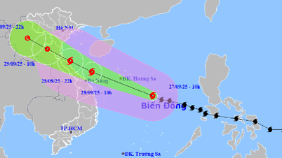
This afternoon, September 15, the National Center for Hydro-Meteorological Forecasting said that a low pressure area is forming in the East Sea in the central part of the East Sea. At 1 p.m., the center of the low pressure area is at about 12.5 - 13.5 degrees North latitude and 118 - 119 degrees East longitude.
In the next 24 hours, the low pressure area will move in the West Northwest direction, at a speed of about 15km/hour and is likely to strengthen into a tropical depression.
Due to the influence of low pressure circulation, the East of the central East Sea area has showers and thunderstorms, winds gradually increasing to level 5, sometimes level 6, gusting to level 8. Waves 2-3m high cause rough seas.
The meteorological agency recommends that vessels operating in the above area should proactively avoid and ensure safety. The National Center for Hydro-Meteorological Forecasting is continuing to monitor this low pressure area.
Source: https://www.sggp.org.vn/vung-ap-thap-tren-bien-dong-kha-nang-manh-thanh-ap-thap-nhiet-doi-post813097.html


![[Photo] Soldiers guard the fire and protect the forest](https://vphoto.vietnam.vn/thumb/1200x675/vietnam/resource/IMAGE/2025/9/27/7cab6a2afcf543558a98f4d87e9aaf95)


![[Photo] Prime Minister Pham Minh Chinh attends the 1st Hai Phong City Party Congress](https://vphoto.vietnam.vn/thumb/1200x675/vietnam/resource/IMAGE/2025/9/27/676f179ddf8c4b4c84b4cfc8f28a9550)


Comment (0)