
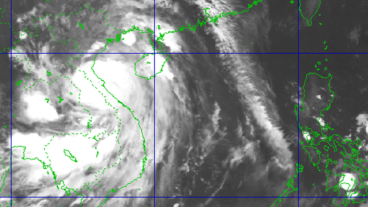
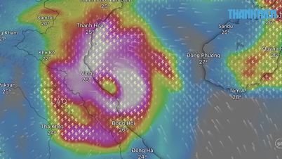
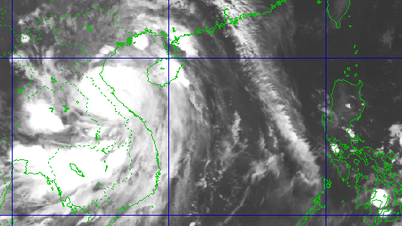
On the morning of June 24, the National Center for Hydro-Meteorological Forecasting informed about the low pressure area in the East Sea, at a position of about 14 degrees north latitude - 119 degrees east longitude.

Low pressure area formed in the East Sea on the morning of June 24
PHOTO: NATIONAL CENTER FOR HYDRO-METEORO-METROLOGICAL FORECASTING
At 7:00 a.m. on June 24, the low pressure area was located at 14.5 - 15.5 degrees north latitude; 117.5 - 118.5 degrees east longitude. Currently, this low pressure area has connected with the low pressure trough with an axis of 14 - 17 degrees north latitude, which will cause dangerous weather in many sea areas.
Thunderstorms are forecast to occur in all sea areas east of the northern East Sea, the middle and southern East Sea (including the sea area of Truong Sa archipelago); sea areas from Binh Thuan to Ca Mau, Ca Mau to Kien Giang , and the Gulf of Thailand.
In addition, the sea area from Binh Thuan to Ca Mau has strong southwest winds of level 5 - 6, gusting to level 7. Waves are 1.5 - 2.5 m high, rough seas. During thunderstorms, there is a possibility of tornadoes, strong gusts of level 6 - 7, and waves over 2 m high.
Accordingly, all vessels operating in the above mentioned sea areas are at high risk of being affected by tornadoes, strong gusts of wind and large waves.
According to the National Center for Hydro-Meteorological Forecasting, in the next 24 hours, the low pressure area will move slowly northwestward and is likely to strengthen into a tropical depression. Fishermen and vessels operating in the above mentioned sea areas should closely monitor forecast information, avoid entering dangerous areas, and proactively take precautions to ensure the safety of people and vehicles at sea.
Source: https://thanhnien.vn/vung-ap-thap-tren-bien-dong-se-manh-len-thanh-ap-thap-nhiet-doi-185250624093219113.htm
![[Photo] High-ranking delegation of the Russian State Duma visits President Ho Chi Minh's Mausoleum](https://vphoto.vietnam.vn/thumb/1200x675/vietnam/resource/IMAGE/2025/9/28/c6dfd505d79b460a93752e48882e8f7e)


![[Photo] Joy on the new Phong Chau bridge](https://vphoto.vietnam.vn/thumb/1200x675/vietnam/resource/IMAGE/2025/9/28/b00322b29c8043fbb8b6844fdd6c78ea)
![[Photo] The 4th meeting of the Inter-Parliamentary Cooperation Committee between the National Assembly of Vietnam and the State Duma of Russia](https://vphoto.vietnam.vn/thumb/1200x675/vietnam/resource/IMAGE/2025/9/28/9f9e84a38675449aa9c08b391e153183)


![[Photo] President Luong Cuong receives Chairman of the State Duma of the Russian Federation Vyacheslav Volodin](https://vphoto.vietnam.vn/thumb/1200x675/vietnam/resource/IMAGE/2025/9/29/6bd456e072504df3a468acbf9b7989c8)


![[Photo] President Luong Cuong receives Chairman of the State Duma of the Russian Federation Vyacheslav Volodin](https://vphoto.vietnam.vn/thumb/402x226/vietnam/resource/IMAGE/2025/9/29/6bd456e072504df3a468acbf9b7989c8)


Comment (0)