
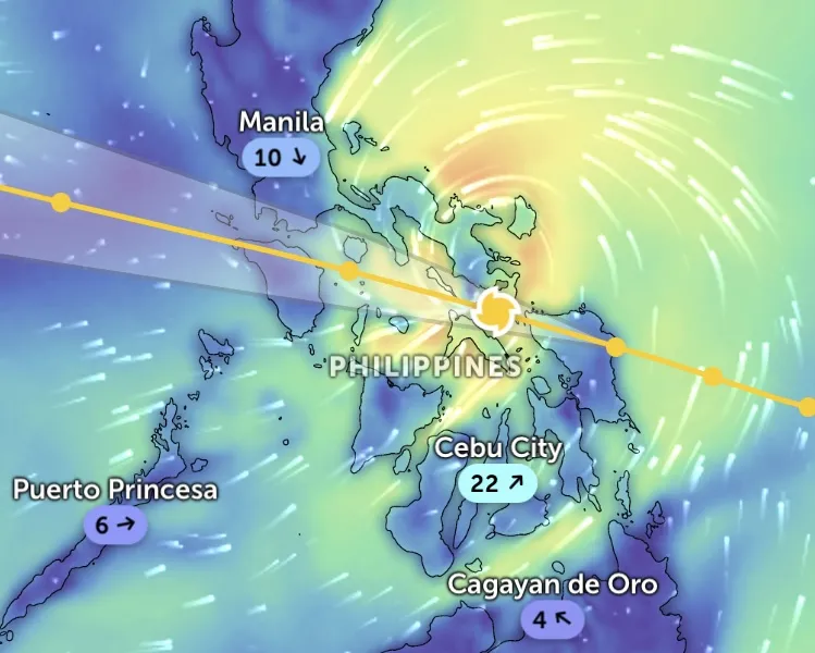
Early this morning, September 26, the latest update from international meteorological centers, storm Bualoi (international name, Philippines calls it Ubong, Vietnam will call it storm number 10) entered the central Philippines with strong winds, accompanied by heavy rain and dangerous high waves.

In particular, the Japan Meteorological Agency (JMA) said that Bualoi was determined to be at the level of a severe tropical storm with sustained winds of 100km/h (equivalent to level 10 storm winds on the Vietnam scale), central pressure of 985hPa (the lower the pressure, the stronger the storm).
At the same time, at 4:00 a.m. this morning, the Hong Kong Observatory (HKO) recorded the storm center at 12.2 degrees North latitude - 124.1 degrees East longitude, right above the central Philippines, with winds of 110km/hour (equivalent to level 11).
The Joint Typhoon Warning Center (JTWC - USA) in the 18:00 UTC bulletin on September 25 (ie 1:00 a.m. September 26 Hanoi time) said that the storm is about 560km southeast of Manila (Philippines), with maximum winds of 100km/h (level 10), pressure of about 993mb (according to the US scale), moving west-northwest at a speed of nearly 25km/h. High waves near the storm's center can reach 7-8m (equivalent to dangerous level waves according to Vietnam standards).
Some other US meteorological models also confirmed that Bualoi is operating around coordinates 12.1 degrees North latitude - 125.5 degrees East longitude with wind speed of 55 knots (about 102km/h, equivalent to level 10), pressure of 993mb, moving West Northwest.

Thus, compared to the times on September 25, when it made landfall in the Philippines, storm Bualoi has decreased by 1-2 levels (from level 12 according to information from the National Center for Hydro-Meteorological Forecasting of Vietnam). Some online forecasting platforms such as Zoom Earth (compiled from JMA, JTWC) predict that in the next 24 hours, the storm will weaken slightly when it passes the Philippines but is likely to strengthen again when it enters the East Sea, even reaching a stronger storm level (possibly exceeding level 12 according to the Vietnam storm wind scale).
 helps people urgently harvest rice before the storm hits.")
These platforms have issued red and orange warnings for the Philippines and surrounding areas due to the risk of strong winds, heavy rains, flash floods and landslides. This is also an early warning signal for Vietnam with the forecast that the eye of Typhoon Bualoi will make landfall in our country.
Vietnam Forecast
According to the National Center for Hydro-Meteorological Forecasting, at 1:00 a.m. this morning, September 26, the center of the storm was at about 11.9 degrees North latitude - 125.2 degrees East longitude, in the central region of the Philippines. The strongest wind near the center of the storm reached level 11 (103-117 km/h), gusting to level 14. The storm moved in a West-Northwest direction at a speed of 25-30 km/h and is forecast to enter the East Sea on the night of September 26, becoming the 10th storm in 2025.

At 1am on September 27, the storm moved west-northwest at a speed of 25-30km/hour, moving deep into the East Sea. The storm's center was at level 11, gusting to level 14.
At 1:00 a.m. on September 28, the storm continued to move in the West-Northwest direction at a speed of 25-30 km/h and was likely to strengthen to level 12, gusting to level 15. At 1:00 a.m. on September 29, the storm was still moving in the West-Northwest direction at a speed of about 25 km/h and strengthening to level 12-13, gusting to level 16. At this time, the dangerous sea area is the Northwest and the middle of the East Sea, including the Hoang Sa archipelago, the southern Gulf of Tonkin and the sea area from Quang Tri to Quang Ngai .
Source: https://www.sggp.org.vn/bao-bualoi-sap-vuot-philippines-manh-tro-lai-tren-bien-dong-post814770.html

![[Photo] Soldiers guard the fire and protect the forest](https://vphoto.vietnam.vn/thumb/1200x675/vietnam/resource/IMAGE/2025/9/27/7cab6a2afcf543558a98f4d87e9aaf95)


![[Photo] Prime Minister Pham Minh Chinh attends the 1st Hai Phong City Party Congress](https://vphoto.vietnam.vn/thumb/1200x675/vietnam/resource/IMAGE/2025/9/27/676f179ddf8c4b4c84b4cfc8f28a9550)


Comment (0)