
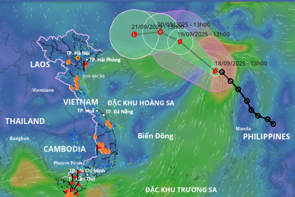
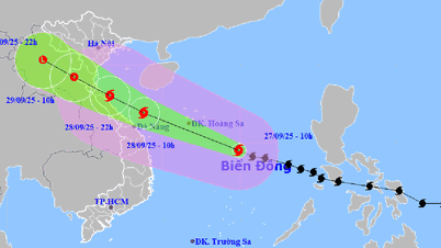
According to the National Center for Hydro-Meteorological Forecasting, this afternoon (September 18), the tropical depression has strengthened into a storm, storm number 8, international name Mitag. The name of storm Mitag was given by Micronesia. Mitag in Yap is a woman's name and means "my eyes".
At 1 p.m., the center of the storm was at about 19.9 degrees North latitude; 118.4 degrees East longitude, in the northeastern sea area of the North East Sea. The strongest wind near the center of the storm was level 8 (62-74 km/h), gusting to level 10. Moving northwest at a speed of 15-20 km/h.
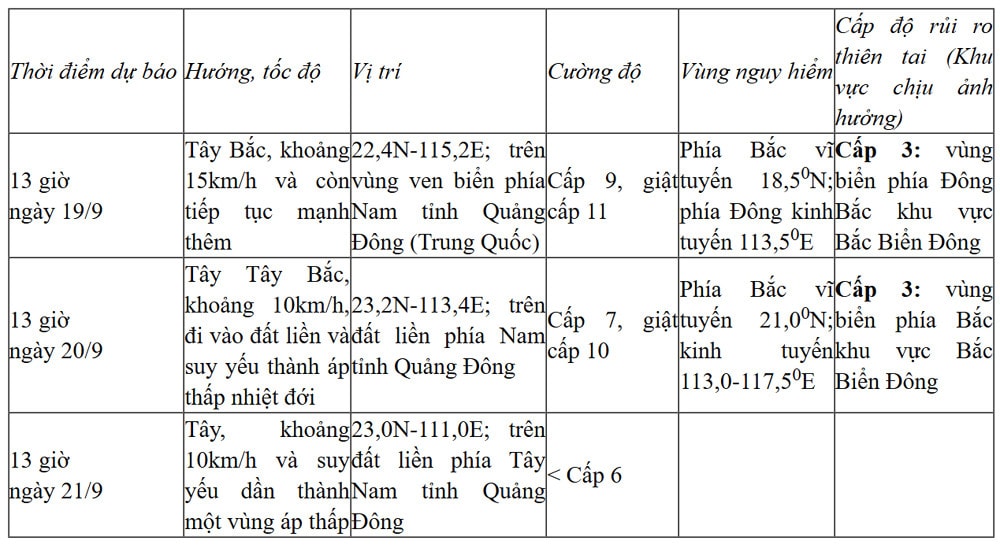
It is forecasted that in the next 24 hours, storm No. 8 will move northwest, intensify to level 9, and make landfall in Guangdong province (China) tomorrow evening (September 19), then weaken and gradually dissipate; it is unlikely to directly affect our country.
Forecast for the next 24 to 72 hours :
However, according to meteorological experts, although it does not directly affect our mainland, storm No. 8 still causes bad weather at sea and on land.
Specifically, the northeastern sea area of the North East Sea has strong winds of level 6-7, gusting to level 9; the area near the storm's eye has strong winds of level 8-9, gusting to level 11, with waves 3-5m high. The sea is very rough.
Vessels operating in the above mentioned dangerous areas are susceptible to the impact of storms, whirlwinds, strong winds and large waves.
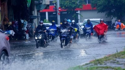
On land, due to the influence of the storm circulation, it is forecasted that on September 22-23, the northern provinces will experience heavy rain.
In addition, the sea area from Lam Dong to Ca Mau (including Ho Chi Minh City) has southwest wind level 4-5, wave height 1.5-2.75m, sea is slightly rough. The sea area of Ca Mau - An Giang - Phu Quoc has southwest wind level 4, sometimes level 5, wave height 1-2m, sea is sometimes slightly rough. In both sea areas, the weather is showery and thunderstorms. During thunderstorms, beware of tornadoes and strong gusts of wind.
PV (synthesis)Source: https://baohaiphong.vn/bao-so-8-da-hinh-thanh-tren-bien-dong-ten-quoc-te-mitag-521130.html

![[Photo] The 1st Congress of Phu Tho Provincial Party Committee, term 2025-2030](https://vphoto.vietnam.vn/thumb/1200x675/vietnam/resource/IMAGE/2025/9/30/1507da06216649bba8a1ce6251816820)
![[Photo] General Secretary To Lam receives US Ambassador to Vietnam Marc Knapper](https://vphoto.vietnam.vn/thumb/1200x675/vietnam/resource/IMAGE/2025/9/29/c8fd0761aa184da7814aee57d87c49b3)
![[Photo] Solemn opening of the 12th Military Party Congress for the 2025-2030 term](https://vphoto.vietnam.vn/thumb/1200x675/vietnam/resource/IMAGE/2025/9/30/2cd383b3130d41a1a4b5ace0d5eb989d)

![[Photo] General Secretary To Lam, Secretary of the Central Military Commission attends the 12th Party Congress of the Army](https://vphoto.vietnam.vn/thumb/1200x675/vietnam/resource/IMAGE/2025/9/30/9b63aaa37ddb472ead84e3870a8ae825)


![[Photo] General Secretary To Lam attends the ceremony to celebrate the 80th anniversary of the post and telecommunications sector and the 66th anniversary of the science and technology sector.](https://vphoto.vietnam.vn/thumb/1200x675/vietnam/resource/IMAGE/2025/9/29/8e86b39b8fe44121a2b14a031f4cef46)


Comment (0)