
Experts predict the time and intensity of storm No. 6 making landfall in the Central region.
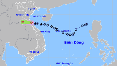
This morning, the tropical depression in the East Sea strengthened into storm No. 6 Nongfa . At 10:00 a.m. on August 30, the center of storm No. 6 was in the Ha Tinh - Quang Tri sea area, about 120km east of the North of Quang Tri.
The strongest wind near the storm center is level 8 (62-74km/h), gusting to level 10-11, moving quickly in the West Northwest direction at a speed of 20-25km/h. The storm's center is in the same area as storm number 5.
Mr. Nguyen Van Huong - Head of Weather Forecast Department, National Center for Hydro-Meteorological Forecasting said that this afternoon and evening, the eye of storm No. 6 is forecast to make landfall in the provinces from South Ha Tinh to North Quang Tri, with strong storm winds of level 6-7, and near the eye of the storm at level 8.
Along the mainland coast from Thanh Hoa to Hue , strong winds level 6, near the storm center strong winds level 7-8, gusts level 9-10.
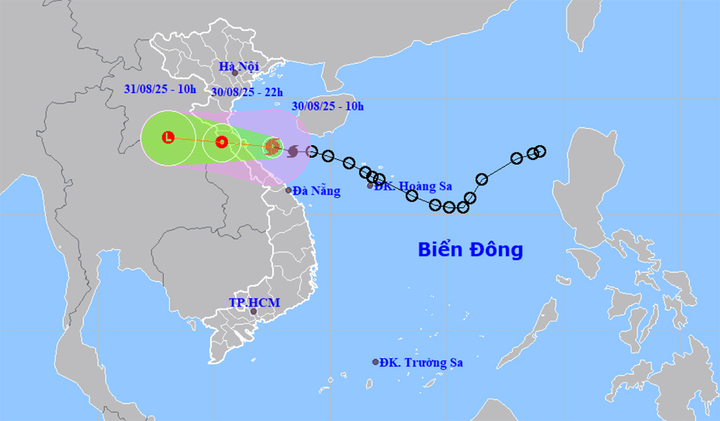
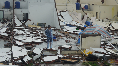
It is forecasted that this afternoon and evening, the eye of storm No. 6 will make landfall in the provinces from South Ha Tinh to North Quang Tri . (Source: NCHMF)
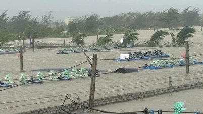
"The storm's winds are not too strong, but we should note that the gusts in the storm can be 3-4 levels different from storm winds, meaning the storm's winds can be level 7-8 but the gusts can be level 9-10, or even level 11-12. Therefore, boats operating in coastal areas, especially fishermen on cages and rafts, need to pay close attention to this strong gusty wind situation," Mr. Huong warned.
Regarding the impact of storm No. 6, Mr. Huong commented that there are two parts of impact: wind and rain.
From South Ha Tinh to North Quang Tri is the area affected by the strongest winds along with the wind circulation of storm No. 6 with strong storm intensity of level 6-7, the area near the storm center is level 8 and the wind gusts are as mentioned above.
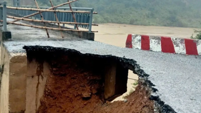
Thanh Hoa to Quang Tri will be the center of heavy rain during this storm. Total rainfall for the whole period will fluctuate from 200 - 400mm, in some places over 600mm.
In particular, from now until August 31, Thanh Hoa to Northern Quang Tri will continue to have heavy rain with total rainfall of 150-250mm, some places over 350mm. The rain will also expand to the midlands and Northern Delta from this evening and tonight until August 31 with total rainfall of 50-120mm, some places over 200mm.
"This afternoon, the storm's circulation has affected the coastal sea area from Thanh Hoa to Hue. With the West Northwest direction, speed of 20km/h, the center of the storm will make landfall this afternoon and evening, the time of the strongest wind we determined is around 3-7pm", Mr. Huong informed.
Commenting on the weather in Hanoi and other areas across the country on National Day, September 2, the Head of the Weather Forecast Department said that storm No. 6 is moving quite quickly, and heavy rain due to the prolonged storm may last until August 31. From September 1 onwards, rain across the country will tend to decrease.
On National Day September 2, the weather across the country is relatively favorable. In Hanoi, there is a possibility of light showers in the morning, but the rain will decrease in the afternoon and evening, and the weather may turn slightly sunny.
The Central region will also have sunshine in the afternoon and evening. The Central Highlands and the South will have sunny afternoons, with the possibility of showers and thunderstorms in the evening and at night.
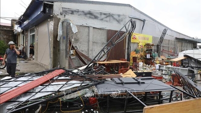
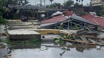
The National Center for Hydro-Meteorological Forecasting noted that storm No. 6 Nongfa causes strong winds of level 8, gusting to level 10-11. This wind level can break tree branches, blow roofs off houses, causing damage to houses. People cannot go against the wind. The sea is very rough, very dangerous for boats and rafts.
The meteorological agency recommends that everyone absolutely must not be subjective.
Vtcnews.vn
Source: https://vtcnews.vn/chuyen-gia-canh-bao-bao-so-6-nongfa-do-bo-chieu-toi-nay-mua-lon-don-dap-ar962743.html
![[Photo] General Secretary To Lam chairs the meeting of the Central Steering Committee on preventing and combating corruption, waste and negativity](https://vphoto.vietnam.vn/thumb/1200x675/vietnam/resource/IMAGE/2025/9/29/fb2a8712315d4213a16322588c57b975)
![[Photo] General Secretary To Lam attends the ceremony to celebrate the 80th anniversary of the post and telecommunications sector and the 66th anniversary of the science and technology sector.](https://vphoto.vietnam.vn/thumb/1200x675/vietnam/resource/IMAGE/2025/9/29/8e86b39b8fe44121a2b14a031f4cef46)
![[Photo] National Assembly Chairman Tran Thanh Man chairs the 8th Conference of full-time National Assembly deputies](https://vphoto.vietnam.vn/thumb/1200x675/vietnam/resource/IMAGE/2025/9/29/2c21459bc38d44ffaacd679ab9a0477c)
![[Photo] General Secretary To Lam receives US Ambassador to Vietnam Marc Knapper](https://vphoto.vietnam.vn/thumb/1200x675/vietnam/resource/IMAGE/2025/9/29/c8fd0761aa184da7814aee57d87c49b3)

![[Photo] Many streets in Hanoi were flooded due to the effects of storm Bualoi](https://vphoto.vietnam.vn/thumb/1200x675/vietnam/resource/IMAGE/2025/9/29/18b658aa0fa2495c927ade4bbe0096df)


Comment (0)