
According to the National Center for Hydro-Meteorological Forecasting, the tropical depression in the sea northwest of Luzon Island (Philippines) has entered the East Sea.
Tropical depression enters the East Sea
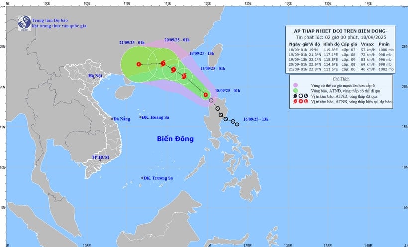
At 1:00 a.m. on September 18, the center of the tropical depression was at about 19 degrees North latitude; 119.8 degrees East longitude, in the northeastern sea area of the North East Sea.
The strongest wind near the center of the tropical depression is level 7 (50-61 km/h), gusting to level 9. The tropical depression moves northwest at a speed of about 15-20 km/h.
It is forecasted that by 1:00 a.m. on September 19, the tropical depression will move northwest at a speed of 15-20 km/h and is likely to strengthen into a storm; in the northeastern sea area of the North East Sea, there will be winds of level 8, gusting to level 10.
The affected area is the northeastern sea area of the North East Sea. Disaster risk level 3.
At 1:00 a.m. on September 20, the tropical depression/storm moved northwest at a speed of about 15 km/h; in the southern area of Guangdong province (China), there were winds of level 8, gusting to level 10. The affected area was the northern sea area of the North East Sea.
During the next 48 to 72 hours, the storm will move mainly to the West, about 10 km per hour, and gradually weaken.
Forecast, on the day and night of September 18, the northeastern sea area of the North East Sea will have strong winds of level 6-7, gusting to level 9; near the storm center, strong winds of level 8, gusting to level 10; waves 2.5-4.5m high; rough seas.
The sea area from Khanh Hoa to Ho Chi Minh City, the area between the East Sea and the Southwest of the East Sea (including the West of Truong Sa archipelago) has Southwest wind level 5, sometimes level 6, gusting to level 7-8; waves 1.5-3 m high; rough sea.
In addition, on the day and night of September 18, the North East Sea, the Central and South East Sea (including the Hoang Sa and Truong Sa special zones), the Gulf of Tonkin, the sea area from South Quang Tri to Ca Mau, Ca Mau to An Giang and the Gulf of Thailand will have scattered showers and thunderstorms; in particular, the sea area northeast of the North East Sea will have storms. During thunderstorms, there is a possibility of tornadoes, strong gusts of wind of level 6-7 and waves over 2m high.
During the day and night of September 19, the northern sea area of the North East Sea will have strong winds of level 8-9, gusts of level 10-11, waves 3-5m high; very rough seas. Disaster risk level due to strong winds at sea: level 2; in particular, the northeastern sea area of the North East Sea will be level 3. All vessels operating in the above areas are at high risk of being affected by tornadoes, strong winds and big waves.
Thunderstorms from Thanh Hoa to Lam Dong and the South
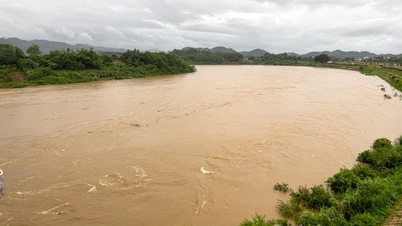
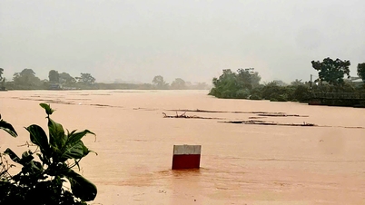
Last night and early this morning (September 18), in the area from Thanh Hoa to Lam Dong, there were scattered showers and thunderstorms, with some places experiencing heavy to very heavy rain. The rainfall from 7:00 p.m. on September 17 to 3:00 a.m. on September 18 was over 60mm in some places, such as: Ho Thai Xuan station (Da Nang) 60.4mm, Nghia Trung station (Quang Ngai) 92.6mm, Ia Mo station (Gia Lai) 113.2mm, Ia Lop station (Dak Lak) 80mm...
Forecast, on the day and night of September 18, the coastal areas of the North, from Thanh Hoa to Quang Tri, will have scattered showers and thunderstorms with rainfall of 10-30 mm, locally heavy rain over 70 mm. Warning of the risk of heavy rain (over 70 mm/3 hours).
")
The area from Hue city to Lam Dong and the South has rain, moderate rain and scattered thunderstorms with rainfall of 20-40mm, locally heavy to very heavy rain over 100mm. Warning of risk of heavy rain (over 80mm/3 hours).
Thunderstorms may produce tornadoes, lightning, hail, and strong gusts of wind. Localized heavy rain may cause flash floods in small rivers and streams, landslides on steep slopes, and inundation in low-lying areas.
Specific weather in each region
The Northwest region has scattered showers and thunderstorms. There is a possibility of tornadoes, lightning and strong gusts of wind during thunderstorms. The lowest temperature is 23-26 degrees Celsius, in some places below 22 degrees Celsius; the highest temperature is 31-34 degrees Celsius.
In the Northeast, the sky is cloudy with scattered showers and thunderstorms, with some heavy rain in coastal areas. During thunderstorms, beware of tornadoes, lightning and strong gusts of wind. The lowest temperature is from 23-26 degrees Celsius, in mountainous areas it is below 22 degrees Celsius; the highest is from 30-33 degrees Celsius, in some places it is above 33 degrees Celsius.
The area from Thanh Hoa to Hue is cloudy with scattered showers and thunderstorms, locally heavy to very heavy rain. Light wind. During thunderstorms, tornadoes, lightning, hail and strong gusts of wind may occur. Lowest temperature from 23-26 degrees Celsius; highest from 29-32 degrees Celsius.
In the South Central Coast region, the weather is cloudy with rain, moderate rain and scattered thunderstorms, locally heavy to very heavy rain. Southwest wind level 2-3. During thunderstorms, there is a possibility of tornadoes, lightning, hail and strong gusts of wind. The lowest temperature is from 23-26 degrees Celsius; the highest is from 29-32 degrees Celsius.
The Central Highlands region is cloudy with rain, moderate rain and scattered thunderstorms, locally heavy to very heavy rain. Southwest wind level 2-3. During thunderstorms, there is a possibility of tornadoes, lightning, hail and strong gusts of wind. The lowest temperature is from 20-23 degrees Celsius; the highest is from 27-30 degrees Celsius, some places are over 30 degrees Celsius.
In the South, the weather is cloudy with rain, moderate rain and scattered thunderstorms, locally heavy to very heavy rain. Southwest wind level 2-3. During thunderstorms, beware of tornadoes, lightning, hail and strong gusts. Lowest temperature from 23-26 degrees Celsius; highest from 29-32 degrees Celsius, some places above 32 degrees Celsius.
Hanoi has occasional showers and thunderstorms. During thunderstorms, there is a possibility of tornadoes, lightning and strong gusts of wind. The lowest temperature is from 25-27 degrees Celsius, the highest is from 31-33 degrees Celsius.
In Ho Chi Minh City, the weather is cloudy with rain, moderate rain and scattered thunderstorms, locally heavy to very heavy rain. Southwest wind level 2-3. During thunderstorms, tornadoes, lightning, hail and strong gusts of wind may occur. The lowest temperature is from 24-26 degrees Celsius; the highest is from 30-33 degrees Celsius.
Source: https://baolamdong.vn/thoi-tiet-18-9-ap-thap-nhiet-doi-vao-bien-dong-co-kha-nang-manh-len-thanh-bao-391896.html
![[Photo] General Secretary To Lam receives US Ambassador to Vietnam Marc Knapper](https://vphoto.vietnam.vn/thumb/1200x675/vietnam/resource/IMAGE/2025/9/29/c8fd0761aa184da7814aee57d87c49b3)
![[Photo] General Secretary To Lam, Secretary of the Central Military Commission attends the 12th Party Congress of the Army](https://vphoto.vietnam.vn/thumb/1200x675/vietnam/resource/IMAGE/2025/9/30/9b63aaa37ddb472ead84e3870a8ae825)
![[Photo] Solemn opening of the 12th Military Party Congress for the 2025-2030 term](https://vphoto.vietnam.vn/thumb/1200x675/vietnam/resource/IMAGE/2025/9/30/2cd383b3130d41a1a4b5ace0d5eb989d)

![[Photo] The 1st Congress of Phu Tho Provincial Party Committee, term 2025-2030](https://vphoto.vietnam.vn/thumb/1200x675/vietnam/resource/IMAGE/2025/9/30/1507da06216649bba8a1ce6251816820)


![[Photo] General Secretary To Lam attends the ceremony to celebrate the 80th anniversary of the post and telecommunications sector and the 66th anniversary of the science and technology sector.](https://vphoto.vietnam.vn/thumb/1200x675/vietnam/resource/IMAGE/2025/9/29/8e86b39b8fe44121a2b14a031f4cef46)


Comment (0)