
Latest storm news update: At 1 p.m. on November 17, the center of super typhoon MAN-YI was at about 15.8 degrees North latitude; 122.0 degrees East longitude, on the southeast coastal area of Luzon Island (Philippines).
Latest storm news update: How strong is Storm Manyi and when will it enter the East Sea?
At 1 p.m. on November 17, the center of super typhoon Manyi was at about 15.8 degrees North latitude; 122.0 degrees East longitude, on the southeast coastal area of Luzon Island (Philippines). The strongest wind near the center of the super typhoon was level 16 (184-201 km/h), gusting to level 17. Moving northwest at a speed of 20 km/h.
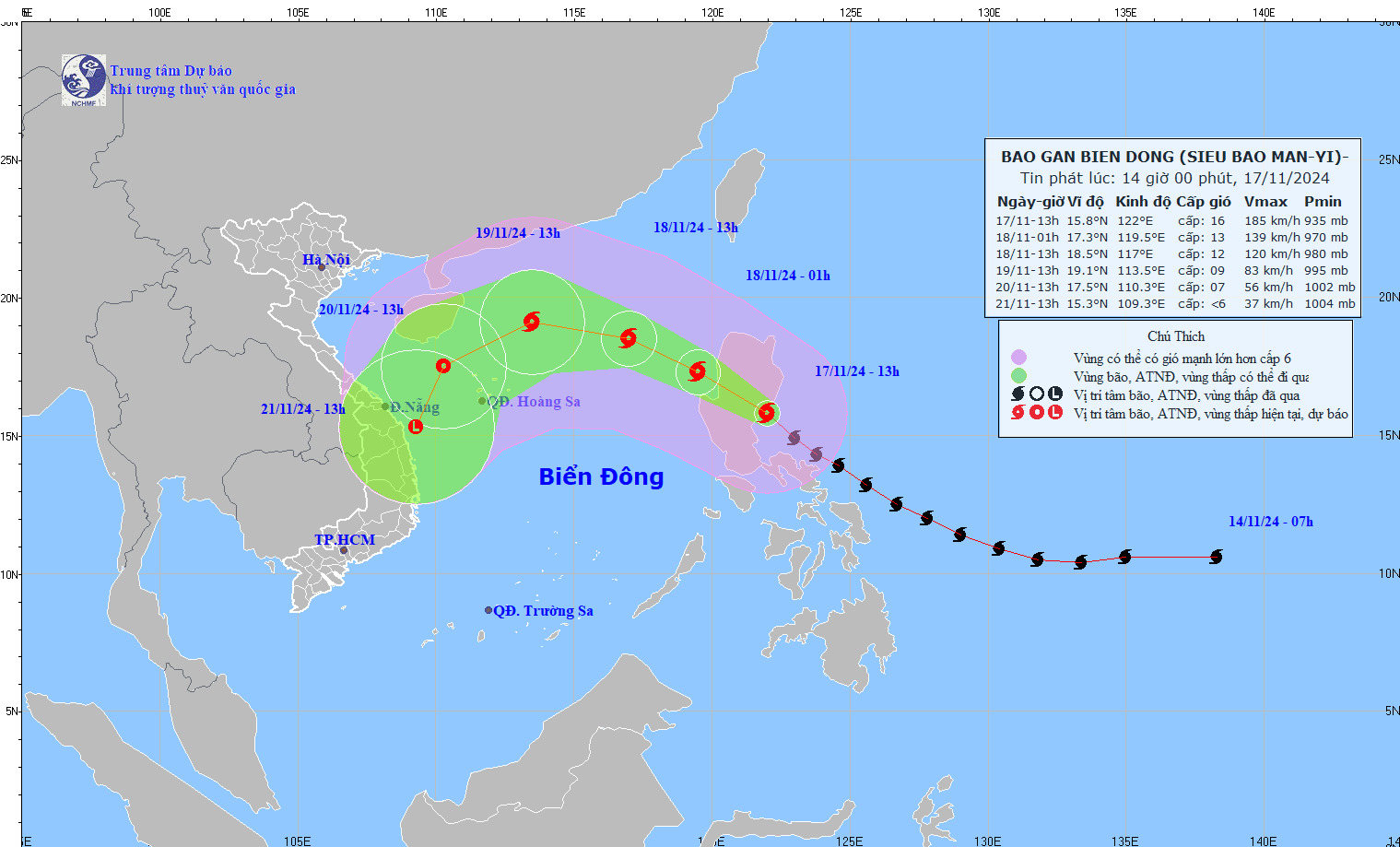
Latest storm news update: How strong is Storm Manyi and when will it enter the East Sea? Photo: NCHMF
Storm Manyi's development in the next 24 to 72 hours
Forecast time | Direction, speed | Location | Intensity | Danger zone | Disaster Risk Level (Affected Area) |
13:00/11/18 | Northwest at about 25km/h, entering the East Sea and gradually weakening. | 18.5N-117.0E; on the eastern sea of the North East Sea; about 640km east-northeast of Hoang Sa archipelago | Level 11-12, level 14 jerk | Latitude 14.5N-19.0N; East of longitude 115.0E | Level 3: East of the North East Sea area |
13:00/19/11 | Northwest, about 15km/h, continuing to weaken | 19.1N-113.5E; above North East Sea area; about 380km northeast of Hoang Sa archipelago | Level 9, level 12 | Latitude 15.0N-21.0N; East of longitude 111.0E | Level 3: North East Sea area |
13:00/20/11 | Southwest, 10-15km/h and gradually weaken into a tropical depression | 17.5N-111.3E; in the sea northwest of Hoang Sa archipelago | Level 6-7, level 9 jerk | Latitude 15.5N-20.5N; longitude 109.5E-116.5E | Level 3: west of the North East Sea area |
From the next 72 to 96 hours, the tropical depression will move in the Southwest direction, traveling 10km per hour, and its intensity will continue to weaken.
On the impact of storm Manyi
The eastern sea area of the North East Sea has strong winds of level 6-7, then increasing to level 8-9, the area near the storm center has levels 10-13, gusts of level 15, waves 2.0-4.0m high, the area near the storm center has 5.0-7.0m; the sea is very rough.
Vessels operating in the above mentioned dangerous areas are susceptible to the impact of storms, whirlwinds, strong winds and large waves.
Urgent response to storm Manyi with gusts above level 17 about to enter the East Sea
It is forecasted that on November 18, storm Manyi will enter the East Sea with a level 12 intensity, gusting to level 15. The Minister of Agriculture and Rural Development has just sent a telegram to the People's Committees of coastal provinces and cities from Quang Ninh to Binh Thuan on how to respond to storm Manyi near the East Sea.
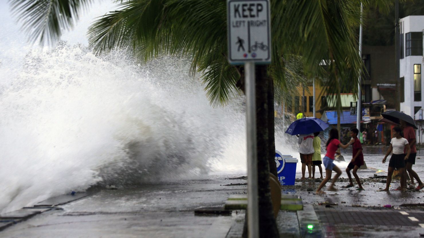
Half a million people were evacuated when super typhoon Manyi made landfall in the Philippines on November 16.
The Minister of Agriculture and Rural Development requested localities to closely monitor the storm's developments; manage vessels at sea; organize ship and boat counting; notify owners of vessels and captains of ships and boats operating at sea of the location, direction of movement and developments of the storm so that they can proactively avoid, escape or not move into dangerous areas.
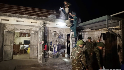
Prepare forces and means for rescue when required. Vietnam Television, Voice of Vietnam, Vietnam News Agency , coastal information stations and mass media agencies from central to local levels strengthen measures to inform about the storm's developments to authorities and people at all levels so that they can proactively prevent and respond promptly and effectively.
Ministries and branches, according to their functions, state management tasks and assigned tasks, proactively direct and coordinate with localities to respond to storm developments. Be on duty seriously (24/24 hours), regularly report to the Ministry of Agriculture and Rural Development (through the Department of Dyke Management and Natural Disaster Prevention and Control).
Regarding the cold air movement, currently (November 17), the cold air mass has been reported to be moving south. Around the evening and night of November 17, this cold air mass will affect some places in the Northeast region of the North; then affect other places in the Northeast and North Central regions, some places in the Northwest and North Central regions. The Northeast wind inland will strengthen to level 3, and level 4 in coastal areas.
From November 18, in the Northeast and Thanh Hoa, the weather will turn cold at night and early morning; from November 20, in the North and North Central regions, the weather will be cold at night and early morning. The lowest temperature during this cold air mass in the North and North Central regions will generally be from 18-20 degrees Celsius, in mountainous areas, some places will be below 15 degrees Celsius.
At sea in the Gulf of Tonkin on the night of November 17, the wind shifted to the Northeast direction, from November 18 gradually increasing to level 6, gusting to level 7-8; rough seas; waves from 2.0-4.0m high. In the North East Sea area, the Northeast wind was strong at level 6-7, gusting to level 8-9; rough seas; waves from 3.0-5.0m high.
Due to the influence of disturbances in the upper easterly wind zone combined with cold air, from early morning on November 18-19, in the North and Central Central regions, there will be scattered showers and thunderstorms, with some places having heavy rain. During thunderstorms, there is a possibility of tornadoes, lightning and strong gusts of wind.
Thunderstorms accompanied by tornadoes, lightning and strong gusts of wind can affect agricultural production, cause trees to fall, damage houses, traffic works and infrastructure.
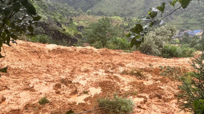
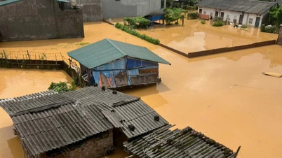
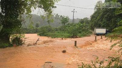
Localized heavy rains may cause flooding in low-lying areas; flash floods in small rivers and streams; landslides on steep slopes. Strong winds and large waves at sea may affect boating and other activities.
Source: https://danviet.vn/nong-tin-bao-moi-nhat-khan-cap-ung-pho-voi-bao-manyi-giat-tren-cap-17-sap-vao-bien-dong-20241117141259378.htm

![[Photo] General Secretary To Lam receives US Ambassador to Vietnam Marc Knapper](https://vphoto.vietnam.vn/thumb/1200x675/vietnam/resource/IMAGE/2025/9/29/c8fd0761aa184da7814aee57d87c49b3)
![[Photo] The 1st Congress of Phu Tho Provincial Party Committee, term 2025-2030](https://vphoto.vietnam.vn/thumb/1200x675/vietnam/resource/IMAGE/2025/9/30/1507da06216649bba8a1ce6251816820)
![[Photo] Solemn opening of the 12th Military Party Congress for the 2025-2030 term](https://vphoto.vietnam.vn/thumb/1200x675/vietnam/resource/IMAGE/2025/9/30/2cd383b3130d41a1a4b5ace0d5eb989d)
![[Photo] General Secretary To Lam, Secretary of the Central Military Commission attends the 12th Party Congress of the Army](https://vphoto.vietnam.vn/thumb/1200x675/vietnam/resource/IMAGE/2025/9/30/9b63aaa37ddb472ead84e3870a8ae825)


![[Photo] General Secretary To Lam attends the ceremony to celebrate the 80th anniversary of the post and telecommunications sector and the 66th anniversary of the science and technology sector.](https://vphoto.vietnam.vn/thumb/1200x675/vietnam/resource/IMAGE/2025/9/29/8e86b39b8fe44121a2b14a031f4cef46)


Comment (0)