
On the afternoon of September 23, experts from the National Center for Hydro-Meteorological Forecasting provided information on the current development of storm Ragasa (storm No. 9). Specifically:
Overview of the developments and current status of storm Ragasa
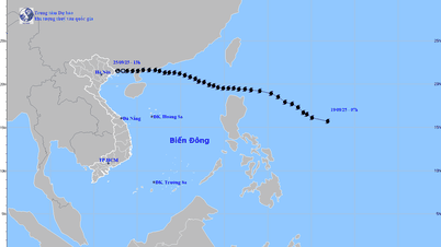
On the afternoon of September 18, a low pressure area in the Northwest Pacific strengthened into a storm, the 18th storm in the Northwest Pacific and named Ragasa.

By the morning of September 22, storm Ragasa reached a strong level of 16 (super typhoon); in the afternoon of the same day, it increased to level 17, gusting above level 17. In the evening of the same day, super typhoon Ragasa crossed the sea north of Luzon Island (Philippines) and entered the East Sea, becoming storm number 9, with a continued strong level of 17, gusting above level 17.
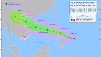
At 1 p.m. on September 23, the center of the super typhoon was located in the northeastern sea of the North East Sea. The strongest wind near the center of the super typhoon was level 16-17 (184-221 km/h), gusting above level 17.
Characteristics of storm No. 9
According to meteorological experts, storm Ragasa is considered the strongest super storm in the world from 2025 to present, surpassing storm Erin (North Atlantic) and storm Yagi (2024).
Fast moving speed: About 20-25km/h.
Wide circulation: The strong wind zone of level 6 has a radius of about 450km around the eye of the storm; level 10 about 200km and level 12 about 100km.
Forecast of developments
Regarding the direction of movement : Up to the present time (13:00 September 23, 2025), the forecasts of international and Vietnamese storm forecasting centers have high consensus on the direction of movement.
That is, the super typhoon will move to the coastal area of Guangdong province (China), then turn west, pass through the northern area of Leizhou peninsula (China), and go along the northern coast of the Gulf of Tonkin.
From noon to afternoon of September 25, the eye of the storm will make landfall in our country. In particular, the area from Quang Ninh - Hung Yen is highly likely to be the eye of the storm.
In terms of intensity : Storm No. 9 will maintain its intensity at level 15-16 from now until the morning of September 24. From the morning of September 24, when moving to the sea area south of Guangdong province (China), the storm will have friction with the terrain, plus the dry air flow of cold air from the North moving down, penetrating the center of the storm. At this time, the storm's intensity will decrease from level 16 to level 11-12 when moving into the Gulf of Tonkin. The level of decrease is also consistent with international forecasts.
The sea was rough, with waves over 10m high.
At sea : The sea area north of the North East Sea has strong winds of level 10-14, the area near the center of the super storm has winds of level 15-17, gusts above level 17, waves over 10m high; rough seas.
From September 24, the eastern sea area of the Gulf of Tonkin (including Bach Long Vi special zone) will have winds gradually increasing to level 6-7, gusting to level 9. From the evening and night of September 24, the Gulf of Tonkin area (including Bach Long Vi special zone, Van Don, Co To, Cat Hai and Hon Dau island) will have winds gradually increasing to level 8-9, waves 2-4m high, the area near the storm center will have winds of level 10-12, gusting to level 14, waves 4-6m high; the sea will be very rough.
Storm surge in coastal areas : The coastal areas of Quang Ninh - Hai Phong provinces have storm surges of 0.5-1m high. There is a high risk of landslides, sea dykes, and destruction of aquaculture areas, ships and boats anchored along the coast due to strong winds, rising sea levels, and large waves.
Area of heavy rain
From the morning of September 25, coastal areas from Quang Ninh to Thanh Hoa will have winds gradually increasing to level 6-7, then increasing to level 8, areas near the storm center will have winds of level 9-10, gusting to level 12; areas deep inland in the Northeast will have strong winds of level 6-7, gusting to level 8-9.

From the night of September 24 to September 26, in the Northern region, Thanh Hoa and Nghe An, there will be heavy to very heavy rain with common rainfall of 100-250mm, locally over 400mm. Beware of heavy rain causing urban flooding.
Heavy rain concentrated in the provinces: Thai Nguyen, Nam Tuyen Quang, Lao Cai, Phu Tho, the Northern Delta, Thanh Hoa;
According to experts, the distribution of rain over time is uneven. On September 25, rain was concentrated in Cao Bang, Thai Nguyen, Lang Son, Quang Ninh, Hai Phong, Bac Ninh, Hung Yen; on September 26-27, rain occurred in Phu Tho, the Northern Delta, and Thanh Hoa.
At the same time, the meteorological agency warned of a high risk of flooding in low-lying areas along rivers, urban areas, and densely populated areas.
“Heavy rain, concentrated in a short period of time, poses a special danger of flash floods and landslides, concentrated in mountainous and midland areas of the North, Thanh Hoa and Nghe An, from September 25-27,” the meteorological expert emphasized.
Source: https://baolaocai.vn/toan-canh-dien-bien-bao-so-9-ragasa-nhan-dinh-vung-tam-diem-do-bo-dat-lien-post882748.html


![[Photo] Binh Trieu 1 Bridge has been completed, raised by 1.1m, and will open to traffic at the end of November.](https://vphoto.vietnam.vn/thumb/1200x675/vietnam/resource/IMAGE/2025/10/2/a6549e2a3b5848a1ba76a1ded6141fae)


Comment (0)