
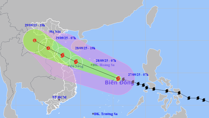
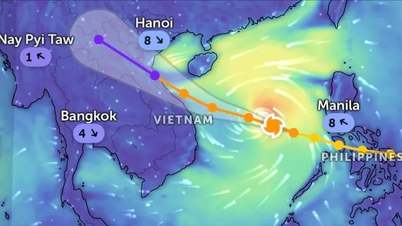
Forecast of location and direction of storm Bualoi at 7am September 27 - Photo: NCHMF
According to the National Center for Hydro-Meteorological Forecasting at 7am on September 27, the center of storm Bualoi was about 480km east-southeast of the Hoang Sa archipelago. The strongest wind near the center of the storm was level 11-12 (103-133km/h), gusting to level 15.
The storm is currently moving very quickly in a west-northwest direction at a speed of about 35km/h - nearly twice the speed of normal storms.
Mr. Mai Van Khiem, Director of the National Center for Hydro-Meteorological Forecasting, said that the movement of storm Bualoi is controlled by a subtropical high pressure system in the north.
"Because the storm in the south of the subtropical high pressure system is controlling and stabilizing, along with the easterly wind zone of the south of this subtropical high pressure system. This is the factor that makes storm Bualoi move almost twice as fast as normal storms" - Mr. Khiem explained clearly.
In addition to moving at a "galloping" speed, the meteorological agency also warned that storm Bualoi has a strong intensity, possibly reaching level 13 (134-149km/h), gusting to level 15 when at sea and when reaching the shore (landing), it is likely to have strong winds of level 10-12 (89-133km/h), gusting to level 14 - horizontal winds even stronger than storm No. 5 Kajiki that made landfall in Nghe An - Ha Tinh a month ago.
Therefore, the range of influence of storms is wide, and can cause the combined effects of many types of natural disasters such as strong winds, heavy rains, floods, flash floods, landslides and coastal flooding.
Specifically, it is forecasted that during today and tonight, the storm will move quickly towards the Hoang Sa archipelago and then the sea areas of the Northern and Central Central provinces, and the storm's intensity is likely to increase.
By 7am tomorrow morning, the storm center will be over the sea from Nghe An to Hue, the strongest wind near the storm center is currently level 12-13 (118-149km/h), gusting to level 16.
Around evening to tomorrow night, the storm is likely to make landfall in the Thanh Hoa to Quang Tri area.
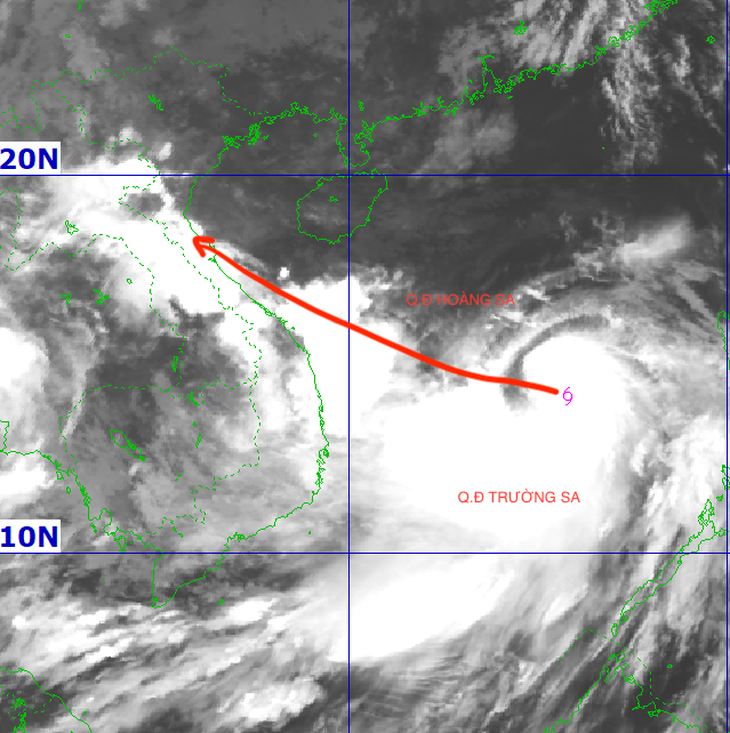
Satellite image of storm Bualoi at 7am this morning - Photo: NCHMF
Due to the influence of storm Bualoi, from the afternoon of September 28 on the mainland from Thanh Hoa to northern Quang Tri, the wind gradually increased to level 6-7, then increased to level 8-9, the area near the storm's eye level 10-12 (wind force can knock down trees, houses, electric poles, causing very heavy damage), gusting to level 14.
Coastal areas from Quang Ninh to Ninh Binh, from South Quang Tri to Hue, winds gradually increase to level 6-7, gusting to level 8-9.
Coastal areas and islands from Ninh Binh to Ha Tinh will have storm surges of 1-2m, and Thanh Hoa and Nghe An will have surges of 1.5-2m. There is a high risk of flooding along dykes, coastal roads, and river mouths due to storm surges and very high waves in the evening and night of September 28.
From early tomorrow morning until September 30, in the North and the area from Thanh Hoa to Hue, there is a possibility of widespread heavy rain, with total rainfall of 100-300mm, locally over 400mm.
In the Northern Delta region and from Thanh Hoa to Ha Tinh, the temperature is commonly 200-400mm, locally over 600mm.
Rivers in the Northern region, from Thanh Hoa to Quang Tri, will experience a flood, the flood peak may reach alert level 1 - alert level 2, in some places above alert level 3. There is a high risk of flooding in low-lying areas along rivers, urban areas and flash floods and landslides in mountainous areas.
Many sea areas have high waves and strong winds.
The northern and central areas of the East Sea (including Hoang Sa special zone) have strong winds of level 8-9, the area near the storm's eye has winds of level 10-13, gusts of level 16, waves of 6-8m high, the area near the storm's eye has waves of 8-10m, and the sea is very rough.
From the evening of September 27, the sea area from Thanh Hoa to Quang Ngai (including Hon Ngu island, Con Co special zone and Ly Son) gradually increased the wind to level 6-7, gusting to level 8-9, waves 3-5m high, rough seas. From the early morning of September 28, the wind increased to level 8-9, the area near the storm center passed level 10-13, gusting to level 16, waves 5-7m high, rough seas.
From early morning on September 28, in the northern area of Bac Bo Gulf (including Bach Long Vi, Van Don, Co To, Cat Hai and Hon Dau islands), the wind gradually increased to level 6-7, then increased to level 8-9, gusting to level 11, waves 3-5m high, very rough seas.
Source: https://tuoitre.vn/vi-sao-bao-bualoi-di-nhanh-gap-doi-thong-thuong-2025092706552944.htm


![[Photo] Prime Minister Pham Minh Chinh attends the groundbreaking ceremony of two key projects in Hai Phong city](https://vphoto.vietnam.vn/thumb/1200x675/vietnam/resource/IMAGE/2025/9/27/6adba56d5d94403093a074ac6496ec9d)


![[Video] Impersonating a reputable organization to call for charity runs and bike rides for the purpose of fraud](https://vphoto.vietnam.vn/thumb/402x226/vietnam/resource/IMAGE/2025/9/27/1d089c05d60145c7a1058ac760ed731a)


Comment (0)