
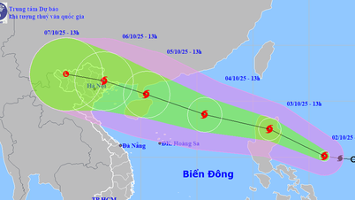
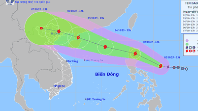
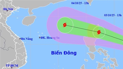
Updated as of the afternoon of October 2, the center of the storm is located at approximately 15.1 degrees North latitude - 126.4 degrees East longitude, in the sea east of the Philippines. The strongest wind near the center of the storm is level 8 (62-74 km/h), gusting to level 10. The storm is moving in a West Northwest direction at a fast speed of about 25 km/h.

The Vietnam Meteorological Agency forecasts that in the next 24 hours, storm Matmo will continue to strengthen and move into Luzon Island (Philippines) with a level 9 intensity, gusting to level 11. On October 4, the storm will enter the North East Sea (becoming storm No. 11) with a level 10-11 intensity, gusting to level 13, about 430km northeast of Hoang Sa archipelago.
In the next 72 hours, storm Matmo is likely to continue to strengthen, reaching level 12 on October 5 , gusting to level 15 when approaching the Leizhou Peninsula (China). The model updated on the afternoon of October 2 by the National Center for Hydro-Meteorological Forecasting predicts that the storm will make landfall in the North (center in Mong Cai area, Quang Ninh province) on October 6.

International forecast models such as JTWC (USA) and JMA (Japan) also presented similar scenarios, both predicting that storm Matmo will likely enter the East Sea on October 4 and head towards the Gulf of Tonkin .
Thus, from around October 5th to 10th, the weather at sea and on land will return to bad and dangerous conditions. Coastal residents and fishermen operating offshore should closely monitor the next bulletins to proactively respond.
Source: https://www.sggp.org.vn/bao-matmo-dang-ap-sat-bien-dong-post816011.html
![[Photo] Binh Trieu 1 Bridge has been completed, raised by 1.1m, and will open to traffic at the end of November.](https://vphoto.vietnam.vn/thumb/1200x675/vietnam/resource/IMAGE/2025/10/2/a6549e2a3b5848a1ba76a1ded6141fae)


Comment (0)