
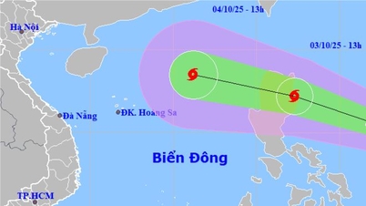
It is forecasted that in the next 24 hours, the tropical depression will likely strengthen into a storm. At 1:00 a.m. on September 7, the center of the storm will be at about 18.7 degrees North latitude - 116.3 degrees East longitude, about 500 km East Northeast of Hoang Sa sea. Wind force is level 8, gusting to level 10. The dangerous area in the East Sea is between latitude 16-20 degrees North latitude; longitude 114.5-120 degrees East longitude. The natural disaster risk level is warned at level 3, the sea area east of the North East Sea.
At 1:00 a.m. on September 8, the storm continued to move northwest at a speed of about 15 km/h and intensified, reaching level 9, gusting to level 11. The forecast location is about 20.9 degrees North latitude - 113.8 degrees East longitude, in the northern sea area of the North East Sea. The dangerous area expanded to about latitude 17.0-22.0 degrees North latitude; longitude 112.0-118.0 degrees East longitude. In the next 48-72 hours, the storm tends to move west-northwest at about 15 km per hour.
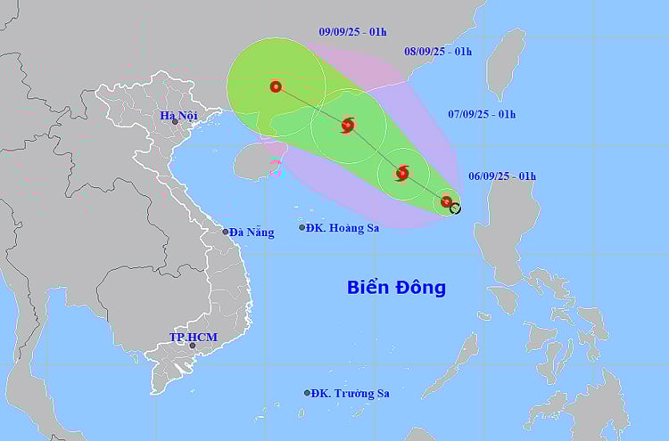 |
| Location and center of tropical depression. Photo: thoitietvietnam |
At sea, the danger zone is expected to have strong winds of level 6, later increasing to level 7-8, gusting to level 10; waves 2-4 m high, rough seas. Ships operating in the area are warned of the risk of thunderstorms, tornadoes, strong winds and large waves, posing many potential risks.
Inland, last night and early this morning (September 6), in many localities from Da Nang to Lam Dong and the Southeast, there was moderate rain, thunderstorms, and locally heavy to very heavy rain. Many locations recorded rainfall of over 130 mm, of which Hoa Phong (Dak Lak) reached 174.4 mm, Quang Tan (Lam Dong) 153 mm, Ia Pior (Gia Lai) 134.6 mm.
It is forecasted that on the day and night of September 6, the area from Da Nang to Lam Dong will continue to have moderate rain, thunderstorms, locally heavy to very heavy rain with common rainfall of 20-40 mm, some places over 100 mm, concentrated in the afternoon and night. In the South, this evening and tonight there will be scattered showers and thunderstorms, locally heavy rain of 10-30 mm, some places over 70 mm. There is a risk of heavy rain of over 100 mm in 3 hours.
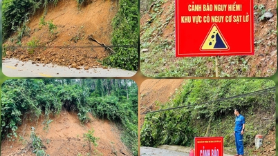
The meteorological agency warns that thunderstorms may cause tornadoes, lightning, hail and strong gusts of wind. Prolonged heavy rains may cause flash floods and landslides in mountainous areas and flooding in low-lying areas. Localities need to continue to closely monitor the development of tropical depressions/storms and prepare response plans to minimize damage.
Weather forecast for regions across the country:
Hanoi capital is cloudy, hot during the day, no rain at night. Light wind. Lowest temperature 26-28 degrees Celsius. Highest temperature 34-36 degrees Celsius, some places above 36 degrees Celsius.
The Northwest region is cloudy, sunny during the day, hot in some places, showers and thunderstorms in some places in the evening and at night. Light wind. Lowest temperature 24-27 degrees Celsius, some places below 22 degrees Celsius. Highest temperature 32-35 degrees Celsius, some places above 35 degrees Celsius.
The Northeastern provinces are cloudy, sunny during the day, hot in some places, showers and thunderstorms in the evening and at night. Light wind. Lowest temperature 25-28 degrees Celsius, in mountainous areas below 23 degrees Celsius. Highest temperature 32-35 degrees Celsius, in some places above 35 degrees Celsius.
Provinces from Thanh Hoa to Hue have clouds, sunny days, scattered showers and thunderstorms in the late afternoon and evening, and scattered showers and thunderstorms in the South in the late afternoon and evening. Light wind. During thunderstorms, there is a possibility of tornadoes, lightning, and strong gusts of wind. Lowest temperature 25-28 degrees Celsius. Highest temperature 31-34 degrees Celsius.
The South Central Coast region is cloudy, with scattered showers and thunderstorms in the morning, moderate rain and thunderstorms in the afternoon and at night, with some places experiencing heavy to very heavy rain. In the North, the wind is light, in the South, the wind is southwest level 2-3. During thunderstorms, there is a possibility of tornadoes, lightning, and strong gusts of wind. The lowest temperature is 24-27 degrees Celsius, in some places below 24 degrees Celsius. The highest temperature is 30-33 degrees Celsius, in some places above 33 degrees Celsius.
The Central Highlands is cloudy with scattered showers and thunderstorms; moderate rain and thunderstorms in the afternoon and at night, with some places experiencing heavy to very heavy rain. Southwesterly winds at level 2-3. There is a possibility of tornadoes, lightning, and strong gusts of wind during thunderstorms. Lowest temperature 20-23 degrees Celsius. Highest temperature 28-31 degrees Celsius.
The South is cloudy with scattered showers and thunderstorms; in the afternoon and at night there will be scattered showers and thunderstorms, with some heavy rain in some places. Southwest wind level 2-3. During thunderstorms there is a possibility of tornadoes, lightning and strong gusts of wind. Lowest temperature 24-27 degrees Celsius. Highest temperature 31-34 degrees Celsius.
Ho Chi Minh City is cloudy with scattered showers and thunderstorms; in the afternoon and at night there will be scattered showers and thunderstorms, with some heavy rain in some places. Southwest wind level 2-3. During thunderstorms there is a possibility of tornadoes, lightning and strong gusts of wind. Lowest temperature 25-27 degrees Celsius. Highest temperature 32-34 degrees Celsius.
Source: https://huengaynay.vn/chinh-tri-xa-hoi/thoi-weather-ngay-6-9-ap-thap-nhiet-doi-tren-bien-dong-co-kha-nang-manh-len-thanh-bao-157497.html


![[Photo] Binh Trieu 1 Bridge has been completed, raised by 1.1m, and will open to traffic at the end of November.](https://vphoto.vietnam.vn/thumb/1200x675/vietnam/resource/IMAGE/2025/10/2/a6549e2a3b5848a1ba76a1ded6141fae)


Comment (0)