
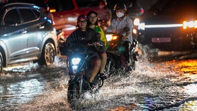
On the evening and night of August 8, the Central Highlands and the Southeast recorded many areas of heavy rain. The rainfall measured from 7 p.m. to 11 p.m. in some places exceeded 30 mm, of which Ia Yeng 1 station (Gia Lai) reached 70.2 mm, La Nga station (Dong Nai) 35.2 mm. Thunderstorms occurred over a wide area, causing traffic disruption, affecting people's daily life and agricultural production.
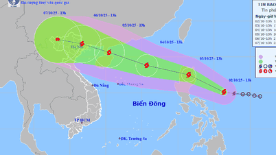
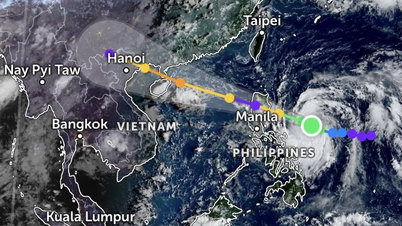
At 1:00 a.m. on August 9, the center of the tropical depression was at about 18.9 degrees North latitude; 117.4 degrees East longitude, in the sea area east of the North East Sea. The strongest wind near the center reached level 6 (39-49 km/h), gusting to level 8. The tropical depression moved slowly westward, at a speed of about 5 km/h.
 |
| Location and center of tropical depression. Photo: thoitietvietnam |
It is forecasted that in the next 24 hours, the tropical depression will move in the West-Northwest direction, at a speed of 10-15km/h and gradually weaken into a low pressure area. At 1:00 a.m. on August 10, the center of the low pressure area will be at about 20.1 degrees North latitude; 114.9 degrees East longitude, in the northern sea area of the North East Sea, about 480km northeast of the Hoang Sa archipelago. The wind intensity remains at level 6, the area of influence is from 18-21 degrees North latitude; 114-119 degrees East longitude.
The disaster risk level is determined at level 3 for the eastern sea area of the North East Sea. Here, there are forecasts of thunderstorms, strong winds of level 6, gusts of level 8; waves of 2-3m high, rough seas. Vehicles operating in the dangerous area need to pay close attention to avoid risks from thunderstorms, whirlwinds, strong winds and big waves.
The meteorological agency recommends that mountainous areas and riverside areas should closely monitor the development of thunderstorms to proactively prepare response plans, ensuring the safety of people, especially in areas with high risk of landslides and flooding. Ship owners and captains should regularly update the marine weather forecast and promptly move away from dangerous areas.
Weather forecast for regions across the country:
Hanoi capital is cloudy, hot and very hot during the day; showers and thunderstorms in some places in the evening and at night. Light wind. During thunderstorms, there is a possibility of tornadoes, lightning and strong gusts of wind. Lowest temperature 27-29 degrees Celsius. Highest temperature 35-37 degrees Celsius, some places over 38 degrees Celsius.
The Northwestern region is cloudy, hot during the day, with some places experiencing severe heat (except Lai Chau and Dien Bien ); showers and thunderstorms in some places in the evening and at night. Light wind. During thunderstorms, there is a possibility of tornadoes, lightning and strong gusts of wind. The lowest temperature is 25-28 degrees Celsius, in some places below 24 degrees Celsius. The highest temperature is 35-37 degrees Celsius, in some places above 38 degrees Celsius; in Lai Chau and Dien Bien only 30-33 degrees Celsius.
The Northeastern provinces are cloudy, hot during the day, with some areas experiencing severe heat; showers and thunderstorms in the evening and at night in some places. Light winds. During thunderstorms, there is a possibility of tornadoes, lightning and strong gusts of wind. Lowest temperature 26-29 degrees Celsius. Highest temperature 34-37 degrees Celsius, some places over 38 degrees Celsius.
Provinces from Thanh Hoa to Hue will be cloudy, hot during the day, with some areas experiencing severe heat; showers and thunderstorms in some places in the evening and at night. Southwesterly winds at level 2-3. During thunderstorms, there is a possibility of tornadoes, lightning and strong gusts of wind. Lowest temperature 26-29 degrees Celsius. Highest temperature 35-37 degrees Celsius, with some places above 37 degrees Celsius.
The South Central Coast region is cloudy, hot during the day, with some places experiencing severe heat; showers and thunderstorms in the evening and at night in some places. Southwest wind level 2-3. During thunderstorms, there is a possibility of tornadoes, lightning and strong gusts of wind. The lowest temperature is 25-28 degrees Celsius. The highest temperature is 35-37 degrees Celsius, with some places above 38 degrees Celsius; in the East of Lam Dong, it is 31-33 degrees Celsius.
The Central Highlands is cloudy with scattered showers and thunderstorms; in the afternoon and evening there will be scattered showers and thunderstorms, with some places experiencing heavy rain. Southwesterly winds level 2-3. During thunderstorms, there is a possibility of tornadoes, lightning, hail and strong gusts of wind. Lowest temperature 20-23 degrees Celsius. Highest temperature 28-31 degrees Celsius, with some places experiencing over 31 degrees Celsius.
The South is cloudy with scattered showers and thunderstorms; in the afternoon and evening there will be scattered showers and thunderstorms, with some heavy rain in some places. Southwest wind level 2-3. During thunderstorms there is a possibility of tornadoes, lightning, hail and strong gusts of wind. Lowest temperature 24-27 degrees Celsius. Highest temperature 31-34 degrees Celsius, some places above 34 degrees Celsius.
Ho Chi Minh City is cloudy with scattered showers and thunderstorms; in the afternoon and evening there will be scattered showers and thunderstorms, with some places experiencing heavy rain. Southwesterly winds level 2-3. During thunderstorms, there is a possibility of tornadoes, lightning, hail and strong gusts of wind. Lowest temperature 25-27 degrees Celsius. Highest temperature 31-34 degrees Celsius, with some places experiencing over 34 degrees Celsius.
Source: https://huengaynay.vn/chinh-tri-xa-hoi/thoi-weather-ngay-9-8-mua-dong-dien-rong-tai-trung-bo-va-nam-bo-ap-thap-nhiet-doi-tren-bien-dong-156549.html
![[Photo] Binh Trieu 1 Bridge has been completed, raised by 1.1m, and will open to traffic at the end of November.](https://vphoto.vietnam.vn/thumb/1200x675/vietnam/resource/IMAGE/2025/10/2/a6549e2a3b5848a1ba76a1ded6141fae)


Comment (0)