
Hurricane Helene has entered the Gulf of Mexico and is forecast to strengthen to Category 4 when it makes landfall in the US state of Florida on the evening of September 26 (local time), CNN reported on September 26, citing an announcement from the National Hurricane Center (NHC).

Hurricane Helene's path map
PHOTO: CNN SCREENSHOT

Hurricane Helene in Central America
PHOTO: US NOAA
According to the US Saffir-Simpson Hurricane Scale, a Category 4 hurricane has winds of 209-251 km/h, capable of causing catastrophic damage ( Yagi is equivalent to Category 5). The NHC forecasts that storm surges of up to 6 m could occur along some coastal areas.
Hurricane Helene could be the strongest storm to hit the US in more than a year. Not only will it hit Florida, it will also sweep across a series of southeastern states.

People fill up gas in Cross City, Florida before the storm hits.
Mandatory evacuation orders have been issued across much of the state and nearly the entire state is on alert as the storm threatens to bring heavy rain, flooding, strong winds and dangerous surf.
Several schools were closed and evacuated, while several airports were also temporarily closed. More than 600 flights were canceled on September 25.
The leaders of Georgia and North Carolina have also declared a state of emergency ahead of Hurricane Helene, bringing the total number of US states to do so to five.

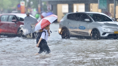
Heavy rain caused by Hurricane Helene caused flooding in Cancun city, Mexico on September 25

Hurricane causes damage in Cancun
The storm hit parts of Mexico's Yucatan Peninsula and Cuba on September 25. Heavy rains flooded vehicles in the Mexican state of Quintana Roo, while strong waves battered the coast, damaging boats. Helene also damaged the power grid, leaving more than 50,000 people without power in the western Cuban province of Pinar del Rio.
Source: https://thanhnien.vn/bao-helene-huong-vao-my-canh-bao-kha-nang-gay-tan-pha-tham-khoc-185240926090250283.htm

![[Photo] The 1st Congress of Phu Tho Provincial Party Committee, term 2025-2030](https://vphoto.vietnam.vn/thumb/1200x675/vietnam/resource/IMAGE/2025/9/30/1507da06216649bba8a1ce6251816820)
![[Photo] Solemn opening of the 12th Military Party Congress for the 2025-2030 term](https://vphoto.vietnam.vn/thumb/1200x675/vietnam/resource/IMAGE/2025/9/30/2cd383b3130d41a1a4b5ace0d5eb989d)
![[Photo] General Secretary To Lam receives US Ambassador to Vietnam Marc Knapper](https://vphoto.vietnam.vn/thumb/1200x675/vietnam/resource/IMAGE/2025/9/29/c8fd0761aa184da7814aee57d87c49b3)
![[Photo] General Secretary To Lam, Secretary of the Central Military Commission attends the 12th Party Congress of the Army](https://vphoto.vietnam.vn/thumb/1200x675/vietnam/resource/IMAGE/2025/9/30/9b63aaa37ddb472ead84e3870a8ae825)


![[Photo] General Secretary To Lam attends the ceremony to celebrate the 80th anniversary of the post and telecommunications sector and the 66th anniversary of the science and technology sector.](https://vphoto.vietnam.vn/thumb/1200x675/vietnam/resource/IMAGE/2025/9/29/8e86b39b8fe44121a2b14a031f4cef46)


Comment (0)