
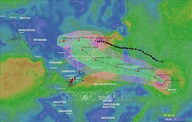
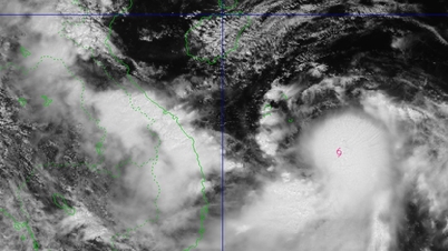
Specifically, at 4:00 p.m. on September 24, the center of the storm was at about 21.6 degrees North latitude; 112.1 degrees East longitude, about 450km east of Mong Cai ( Quang Ninh ). The strongest wind near the center of the storm was level 13 (134-149km/h), gusting to level 16. Moving in the West Northwest direction at a speed of about 20km/h.
Forecast, by 4am on September 25th, the storm will be about 180km east of Mong Cai with wind force of level 10, gusting to level 12, speed of about 20km/h and gradually weakening. The sea area northwest of the North East Sea, the area north of the Gulf of Tonkin has a level 3 natural disaster risk level.
At 4:00 p.m. on September 25, the storm on the mainland of Quang Ninh province with winds of level 7, gusts of level 9, moved westward at a speed of about 20 km/h and gradually weakened into a tropical depression. The northern Gulf of Tonkin; the northeastern coast had a natural disaster risk level of level 3. At 4:00 a.m. on September 26, the tropical depression weakened into a low pressure area, moving westward; on the mainland of the northwest region of the North, the winds were below level 6.
Due to the influence of the storm, in the northwest sea area of the North East Sea, there are strong winds of level 8-11, near the storm center, level 12-13, gusts of level 16, waves 7-9m high; rough seas.
The eastern sea area of the northern Gulf of Tonkin (including Bach Long Vi special zone) has strong winds of level 6-7, gusts of level 9. From the night of September 24, the northern Gulf of Tonkin area (including Bach Long Vi special zone, Van Don, Co To, Cat Hai and Hon Dau island) has winds gradually increasing to level 7-8, waves 2-4m high, near the storm center level 9-10, gusts of level 12, waves 3-4m high; very rough seas.
The coastal areas of Quang Ninh province have storm surges of 0.3-0.5m. Ships and boats anchored along the coast and aquaculture areas are strongly affected by strong winds, big waves and rising sea levels.
On land, from early morning on September 25, coastal areas from Quang Ninh to Hung Yen will have winds gradually increasing to level 6-7, near the storm center level 8-9, gusting to level 11; inland areas in the Northeast, there will be strong winds of level 5, in some places level 6, gusting to level 7-8.
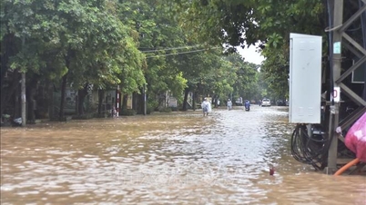
The National Center for Hydro-Meteorological Forecasting also forecasts that from the night of September 24 to the end of the night of September 26, in the Northern region, Thanh Hoa and Nghe An, there will be heavy to very heavy rain with common rainfall of 150-300mm, locally over 450mm. Beware of heavy rain causing urban flooding.
From September 25-27, there is a possibility of a flood on rivers in the Northern region, Thanh Hoa, Nghe An. The flood peak on Thao River and small rivers is likely to rise to alert level 2 - alert level 3; the flood peak on Lo River, upstream Thai Binh River, Hoang Long River, Buoi River, upstream Ma River is likely to rise to alert level 1 - alert level 2, with some rivers above alert level 2. Heavy rain is likely to cause flooding in low-lying areas; flash floods on small rivers and streams, and landslides on steep slopes.
Due to the influence of the wide storm circulation, it is necessary to guard against the risk of thunderstorms, tornadoes and strong gusts of wind both before and during the storm's landfall.
Source: https://baotintuc.vn/van-de-quan-tam/bao-so-9-tiep-tuc-suy-yeu-va-tien-sat-quang-ninh-20250924172810489.htm


![[Photo] Prime Minister Pham Minh Chinh attends the groundbreaking ceremony of two key projects in Hai Phong city](https://vphoto.vietnam.vn/thumb/1200x675/vietnam/resource/IMAGE/2025/9/27/6adba56d5d94403093a074ac6496ec9d)


Comment (0)