
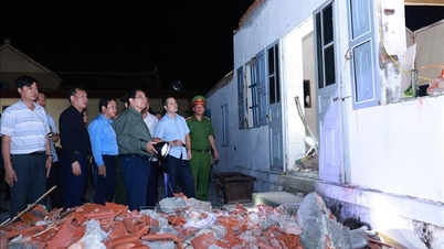
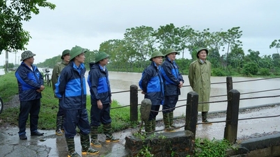
Implementing the directive of the People's Committee of Ha Tinh province, the Border Guard Command - Provincial Military Command implemented a sea ban from 7:30 a.m. on September 27, 2025.
To proactively respond to storm No. 10, the Ha Tinh Border Guard Command has sent a telegram directing units on the two routes to regularly monitor and grasp the developments of storm No. 10 on mass media; strictly maintain on-duty regimes, and be ready with forces and means to participate in handling situations when they arise.
.")
At the same time, develop a plan to direct and inspect the implementation of prevention and response to storm No. 10 and a plan to use forces and means to prevent and respond to storm No. 10. Establish 2 inspection teams of the Provincial Border Guard Command to direct and inspect the implementation of prevention and response to storms in the areas of coastal units.
Coordinate with local authorities to notify ship owners and captains of the developments of storm No. 10 and dangerous weather at sea to have a production plan to ensure safety; at the same time, direct watchtowers to notify vehicles operating at sea and request them to move away from the storm's path.

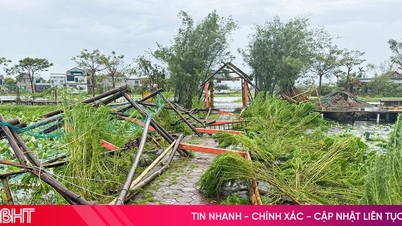
At fishing ports and storm shelters in the province, fishing vessels of local fishermen and neighboring provinces have safely taken shelter from the storm. At the same time, they must comply with the instructions of management units, border guards, etc. to ensure the safety of people and property. Currently, 100% of boats/workers have safely anchored at the ports (3,982 vessels/10,992 workers).
Fisherman Nguyen Van Tuan (Thien Cam commune) said: "As soon as we received the notice of the sea ban, my family immediately brought the boat back to port. We fishermen are always proactive, closely monitoring the storm's developments to bring the boat to a safe place according to the Border Guard's orders."
According to the forecast of Ha Tinh Hydrometeorological Station, from the evening of September 27, the sea area of Ha Tinh province will gradually increase to level 6-7, gusting to level 8-9, waves 3.0-5.0m high, rough seas. From early morning of September 28, the wind will increase to level 8-9, the area near the storm center will increase to level 10-13, gusting to level 16, waves 5.0-7.0m high, rough seas (extremely destructive, extremely strong waves, sinking large tonnage ships).
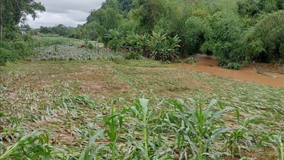
Tides in the coastal areas of Ha Tinh are on the rise and are at relatively high levels. Storm surges are 1.0-1.5m high. There is a risk of flooding low-lying areas outside the dyke, coastal roads, landslides of dykes, seawalls, destruction of aquaculture areas, ships and boats anchored along the coast due to strong winds, rising sea levels and big waves.
All vessels and other activities in Ha Tinh waters are at risk of being affected by tornadoes, strong winds and large waves.
Heavy rain forecast for Ha Tinh province: From September 28 to 30, Ha Tinh province is likely to experience widespread heavy rain with total rainfall ranging from 200-400mm, locally over 500mm.
Source: https://baohatinh.vn/ha-tinh-cam-bien-tu-7h30-sang-nay-phong-tranh-bao-so-10-post296316.html
![[Photo] Solemn opening of the 12th Military Party Congress for the 2025-2030 term](https://vphoto.vietnam.vn/thumb/1200x675/vietnam/resource/IMAGE/2025/9/30/2cd383b3130d41a1a4b5ace0d5eb989d)
![[Photo] Panorama of the cable-stayed bridge, the final bottleneck of the Ben Luc-Long Thanh expressway](https://vphoto.vietnam.vn/thumb/1200x675/vietnam/resource/IMAGE/2025/9/30/391fdf21025541d6b2f092e49a17243f)
![[Photo] President Luong Cuong receives President of the Cuban National Assembly Esteban Lazo Hernandez](https://vphoto.vietnam.vn/thumb/1200x675/vietnam/resource/IMAGE/2025/9/30/4d38932911c24f6ea1936252bd5427fa)
![[Photo] General Secretary To Lam, Secretary of the Central Military Commission attends the 12th Party Congress of the Army](https://vphoto.vietnam.vn/thumb/1200x675/vietnam/resource/IMAGE/2025/9/30/9b63aaa37ddb472ead84e3870a8ae825)
![[Photo] The 1st Congress of Phu Tho Provincial Party Committee, term 2025-2030](https://vphoto.vietnam.vn/thumb/1200x675/vietnam/resource/IMAGE/2025/9/30/1507da06216649bba8a1ce6251816820)


Comment (0)