
Due to the influence of the tropical depression, Quang Binh province has had moderate to heavy rain, and in some places very heavy rain and thunderstorms, with a risk of flash floods and landslides.
 |
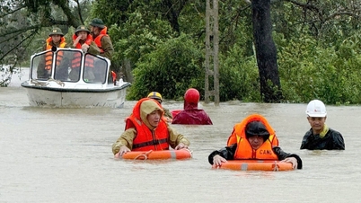
| Floodwaters raging in Minh Hoa district, Quang Binh province. (Source: Environment and Urban Newspaper) |
Heavy rain caused flooding and cut off some roads in the border area of Quang Binh.
According to the Quang Binh Provincial Border Guard Command, from September 25 to the morning of September 26, heavy rain over a large area flooded a number of roads and cut off traffic in the land border area of the two mountainous districts of Minh Hoa and Tuyen Hoa.
The road to Ha village ( Thanh Hoa commune, Tuyen Hoa district) is flooded about 0.3m, with a risk of local isolation.
Points in Minh Hoa district such as: the road to Hoa Son commune is flooded from 0.7-1m deep, about 15m long; the bridge from Luong Nang village to Thuan Hoa village (Hoa Son commune) is flooded about 1m deep, making it impossible for people and vehicles to pass.
At Ka Ai, Ka Dinh, Ka Oc, Ha Nong sluices (Dan Hoa commune), water level rose from 1-1.5m...
National Highway 12A, section Km 121+800, in Yleng village (Dan Hoa commune), had a landslide of about 50 cubic meters of rock and soil, causing traffic congestion.
To ensure people's safety, the Cha Lo international border gate border guard station has dispatched forces to coordinate with local authorities to set up warnings and notify Road Management Company 909 to urgently fix the landslide site, ensuring road clearance for people and vehicles to move smoothly.
On the sea border, according to the Quang Binh Border Guard Command, there are 6,583 vehicles with 19,395 workers in the province; 6,546 vehicles are anchored at the port.
As of 9:30 p.m. on September 25, there were 37 vessels with 259 workers operating at sea. These vessels have received information about the tropical depression and proactively prepared plans to ensure safety.
Faced with complicated and dangerous weather developments, the Provincial Border Guard Command has directed Border Guard stations on the two border lines to be proactive and ready with support plans to ensure people's safety.
Units proactively stockpile food and necessities to prevent long-term isolation; keep abreast of information about people in the forest and notify and call for their safe return before floods.
At the same time, deploy forces to closely follow the area; set up warnings, control, guide, and divert traffic at culverts, spillways, deeply flooded areas, ferry terminals, and points at risk of landslides; prepare forces and means to promptly rescue when situations arise...
The Quang Binh Provincial Border Guard Command directed units to always update weather conditions, keep in touch and inform owners of vehicles at sea about the developments of the tropical depression, request ships and boats to find safe shelters; prepare forces and means to be ready to respond to tasks and help people prevent and combat natural disasters...
Flood news on Gianh River (Quang Binh); flood warning news on rivers from Nghe An to Ha Tinh
Current status of developments in the past 12 hours
Floods upstream of Gianh River (Quang Binh) at Dong Tam have peaked at 13.36m (5am on September 26), 0.36m above alert level 2 and are decreasing.
Currently, the flood downstream of Gianh River is rising. At 7:00 a.m. on September 26, the water level on Gianh River at Dong Tam was 12.93m, 0.07m below alarm level 2; at Mai Hoa it was 3.99m, 0.99m above alarm level 1.
Ha Tinh rivers are rising and are still below level 1.
Forecast
In the next 6-12 hours, the flood in the lower Gianh River will continue to rise. This afternoon (September 26), the flood on the Gianh River at Mai Hoa peaked at 5.2m above BĐ2 by 0.2m. In the next 12-24 hours, the flood on the Gianh River will gradually subside.
Warning
From now (September 26) to September 28, there is a possibility of a flood occurring on rivers from Nghe An to Ha Tinh, with flood levels rising from 2-4m in the upper reaches of rivers and from 1.5-3.0m in the lower reaches.
During this flood, the flood peak water level in the upper reaches of Ca River (Nghe An), La River (Ha Tinh) is at level BĐ1 and above BĐ1; the downstream is below BĐ1.
There is a high risk of flash floods and landslides in mountainous areas, flooding in low-lying areas, riverside areas, and urban areas in provinces from Nghe An to Quang Binh.
Flood disaster risk warning level: Level 2.
Flood impact warning:
Floods on rivers cause inundation of low-lying areas along rivers, affecting activities such as water transport, aquaculture, agricultural production, people's lives and socio-economic activities.
Source
![[Photo] Solemn opening of the 12th Military Party Congress for the 2025-2030 term](https://vphoto.vietnam.vn/thumb/1200x675/vietnam/resource/IMAGE/2025/9/30/2cd383b3130d41a1a4b5ace0d5eb989d)
![[Photo] Panorama of the cable-stayed bridge, the final bottleneck of the Ben Luc-Long Thanh expressway](https://vphoto.vietnam.vn/thumb/1200x675/vietnam/resource/IMAGE/2025/9/30/391fdf21025541d6b2f092e49a17243f)

![[Photo] General Secretary To Lam, Secretary of the Central Military Commission attends the 12th Party Congress of the Army](https://vphoto.vietnam.vn/thumb/1200x675/vietnam/resource/IMAGE/2025/9/30/9b63aaa37ddb472ead84e3870a8ae825)
![[Photo] President Luong Cuong receives President of the Cuban National Assembly Esteban Lazo Hernandez](https://vphoto.vietnam.vn/thumb/1200x675/vietnam/resource/IMAGE/2025/9/30/4d38932911c24f6ea1936252bd5427fa)
![[Photo] The 1st Congress of Phu Tho Provincial Party Committee, term 2025-2030](https://vphoto.vietnam.vn/thumb/1200x675/vietnam/resource/IMAGE/2025/9/30/1507da06216649bba8a1ce6251816820)


Comment (0)