
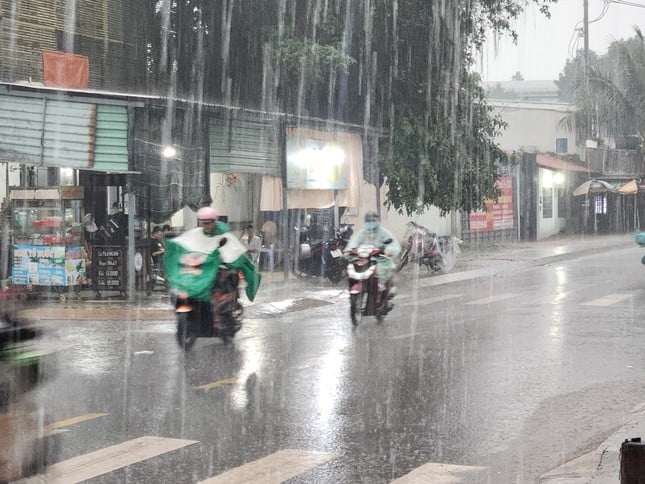
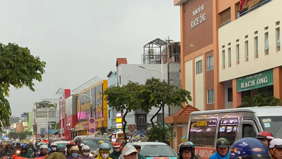
TPO - On the morning of November 13, many areas in Ho Chi Minh City experienced widespread heavy rain, accompanied by thunderstorms, lightning, and strong gusts of wind.
TPO - On the morning of November 13, many areas in Ho Chi Minh City experienced widespread heavy rain, accompanied by thunderstorms, lightning, and strong gusts of wind.
According to Tien Phong reporter, at 9am this morning, November 13, heavy rain appeared in the eastern and central areas of Ho Chi Minh City. After that, the thunderstorm continued to develop and caused very heavy rain in the neighboring districts such as District 8, Binh Tan District and Binh Chanh District,...
“I was riding my motorbike on the road when it suddenly started to rain heavily, forcing many people to seek shelter for fear of danger from thunderstorms,” said Le Van Phong (living in District 8).
Clip: Heavy rain in Ward 16, District 8, Ho Chi Minh City on the morning of November 13. |
According to the National Center for Hydro-Meteorological Forecasting, through monitoring satellite cloud images, lightning positioning images and weather radar images, convective clouds still exist and develop in the Cam My area, Long Khanh Town (Dong Nai); Can Gio (HCMC); Tan Thanh ( Ba Ria - Vung Tau ).
It is forecasted that in the next 3 hours, these convective clouds will continue to cause showers and thunderstorms in the above mentioned area, then expand to neighboring areas. During the thunderstorms, there is a possibility of tornadoes, lightning, hail and strong gusts of wind.
 |
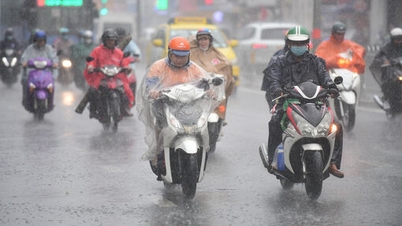
The meteorological agency forecasts that in mid-November, disturbances in the easterly wind zone are likely to cause showers and thunderstorms in the Ho Chi Minh City area for about 1-2 days. Illustration: Pham Nguyen |
According to the Southern Hydrometeorological Station, currently, Ho Chi Minh City and some southern provinces and cities are experiencing thunderstorms. The weather pattern causing rain is influenced by many factors. In particular, the cold continental high pressure continues to weaken and move eastward. The equatorial low pressure trough has an axis at about 4-7 degrees North latitude. The tropical low pressure weakened from storm No. 7 is active in the waters west of the Hoang Sa archipelago and is connected to the Tojari storm circulation in the waters off the eastern coast of the Philippines. Above, the subtropical high pressure over the Central region is active.
During mid-November, the cold air is forecast to intensify and diffuse southward, becoming stronger and stronger. Accompanying the strengthening waves are disturbances in the easterly wind zone that are likely to cause showers and thunderstorms in the Ho Chi Minh City area for about 1-2 days.


Source: https://tienphong.vn/mua-trang-troi-o-tphcm-post1691096.tpo

![[Photo] Panorama of the cable-stayed bridge, the final bottleneck of the Ben Luc-Long Thanh expressway](https://vphoto.vietnam.vn/thumb/1200x675/vietnam/resource/IMAGE/2025/9/30/391fdf21025541d6b2f092e49a17243f)
![[Photo] President Luong Cuong receives President of the Cuban National Assembly Esteban Lazo Hernandez](https://vphoto.vietnam.vn/thumb/1200x675/vietnam/resource/IMAGE/2025/9/30/4d38932911c24f6ea1936252bd5427fa)
![[Photo] The 1st Congress of Phu Tho Provincial Party Committee, term 2025-2030](https://vphoto.vietnam.vn/thumb/1200x675/vietnam/resource/IMAGE/2025/9/30/1507da06216649bba8a1ce6251816820)
![[Photo] Solemn opening of the 12th Military Party Congress for the 2025-2030 term](https://vphoto.vietnam.vn/thumb/1200x675/vietnam/resource/IMAGE/2025/9/30/2cd383b3130d41a1a4b5ace0d5eb989d)
![[Photo] General Secretary To Lam, Secretary of the Central Military Commission attends the 12th Party Congress of the Army](https://vphoto.vietnam.vn/thumb/1200x675/vietnam/resource/IMAGE/2025/9/30/9b63aaa37ddb472ead84e3870a8ae825)


Comment (0)