
 on September 19")
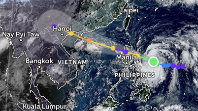
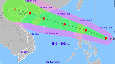
Updated information as of the afternoon of September 19 from international meteorological forecasting agencies, storm Ragasa (meaning "Speed" - the name nominated by the Philippines) has increased in intensity and speed in the East of the Philippines, with the possibility of reaching super typhoon level when approaching the Luzon Strait (Philippines) before entering the East Sea around September 23.
Meteorological experts say that the world is currently offering many different forecast models on the direction of this super typhoon. Most predict that the center of the storm will move towards the coast of Guangdong (China), but the models are currently not consistent on how it will move after that.
According to the Joint Typhoon Warning Center (JTWC), on the afternoon of September 19, the eye of the storm was at about 16 degrees North latitude - 130.7 degrees East longitude (strong winds of level 8, gusts of level 10). However, by September 23, the storm will be at level 14-15, gusts of over level 17, and on September 24, when moving to the area off the coast of Southeast China, the storm will be at about level 14, gusts of level 16-17.

On September 19, the National Center for Hydro-Meteorological Forecasting of Vietnam also issued an early warning about this storm (normally, according to regulations, when a storm enters the East Sea, the Vietnam meteorological agency will issue a warning).
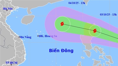
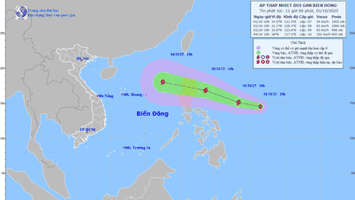
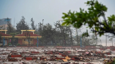
According to this center, on September 22, storm Ragasa may reach level 14-15, gusting over level 17, and from the evening of September 22, the Northeast East Sea will have strong winds of level 6-7, then increasing to level 8-9, and from September 23, the North East Sea (including Hoang Sa archipelago) will be directly affected, with waves possibly over 10m high (average storms only cause waves of 3-4m).
The Hong Kong Meteorological Department (China) said that storm Ragasa is likely to enter the North East Sea early next week and could reach super typhoon strength, causing the weather in the area to worsen significantly by mid-week.
However, some online forecasting platforms (such as Windy, based on data from the European Center for Medium-Range Climate Forecasts - ECMWF and the US Global Climate Warning System - GFS) believe that after passing Luzon Island into the East Sea, the storm will weaken due to more unfavorable conditions.
 forecast model updated on the evening of September 19")
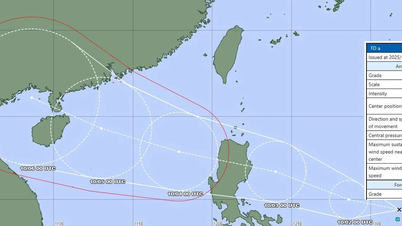
On the afternoon of September 19, Mr. Hoang Phuc Lam, Deputy Director of the National Center for Hydro-Meteorological Forecasting, said that currently, forecast models are strongly dispersed at the orbital mark from September 23, with 3 orbital groups.
Specifically: The eye of the storm may deviate north to enter the east of Taiwan, or deviate south along the 20th parallel towards Hainan Island (China) - if following this trajectory, it is likely to reach very strong intensity. The average scenario is that the storm heads towards Hong Kong (China).
Meteorological experts said that the distance between the storm's center on September 24 between current models could lead to a difference of approximately 1,000km, leading to a large difference in intensity and range of impact.

The impact of super typhoon Ragasa on the northern East Sea is almost certain, but the risk to mainland Vietnam will gradually increase next week and will depend on the storm's trajectory on September 23.
The National Civil Defense Steering Committee requests response to storm Ragasa
On the afternoon of September 19, Mr. Tran Duc Thang, Acting Minister of Agriculture and Environment , Deputy Head of the National Civil Defense Steering Committee, signed a telegram to 15 coastal provinces and cities from Quang Ninh to Lam Dong, along with many related ministries and branches, requesting proactive measures to respond to storm Ragasa.
The Steering Committee requests coastal localities to closely monitor storm forecast information, promptly notify operating vessels to avoid and ensure safety of people and property; prepare forces and means to be ready for rescue; be on duty seriously and regularly report to the Steering Committee.
The telegram was also sent to the Prime Minister, Deputy Prime Minister Tran Hong Ha, the Government Office for reporting, the Ministry of National Defense, the Ministry of Public Security, the Ministry of Construction, the Ministry of Foreign Affairs, rescue agencies and the press to coordinate in implementing response measures.
Source: https://www.sggp.org.vn/nhieu-du-bao-khac-nhau-ve-huong-di-cua-sieu-bao-ragasa-post813806.html


Comment (0)