
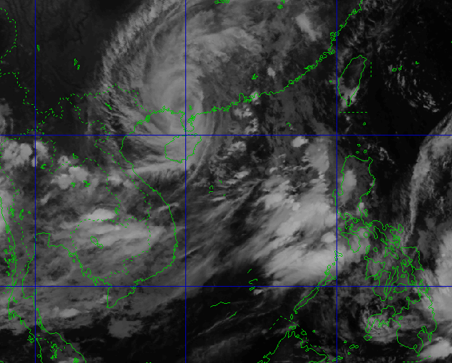
Location and direction of storm Ragasa
According to the National Center for Hydro-Meteorological Forecasting, at 10:00 p.m. on September 24, the center of storm Ragasa was located at about 21.6 degrees North latitude; 110.7 degrees East longitude, about 300km east of Mong Cai ( Quang Ninh ). The strongest wind near the center of the storm reached level 12, gusting over level 15. In the next 3 hours, the storm will move westward at a speed of about 20km/h.
Storm No. 9 Ragasa heads towards the North, risk of widespread flooding
In the next 9 hours, storm No. 9 Ragasa will move west at a speed of about 20 km/h, with a strong intensity of level 8-9, gusting to level 11.
By the morning of September 25, the storm's center was about 100 km from Mong Cai (Quang Ninh), and was forecast to weaken into a tropical depression as it moved deeper into the northeastern mainland.
The northwestern part of the East Sea has strong winds of level 8-10, the area near the storm center can reach level 11-12, gusts of level 15, waves 6-8 m high, rough seas. The northern part of the Gulf of Tonkin, especially islands such as Bach Long Vy, Van Don, Co To, Cat Hai, Hon Dau, has strong winds of level 6-8, waves 2-4 m high. The coastal area of Quang Ninh has a water level rise of 0.3-0.5 m, affecting moored boats and aquaculture areas.
From the morning of September 25, the coastal areas from Quang Ninh to Hung Yen will have strong winds of level 6-7, near the storm center level 8, gusting to level 9-10. The inland areas of the Northeast will have winds of level 5-6, gusting to level 7-8.
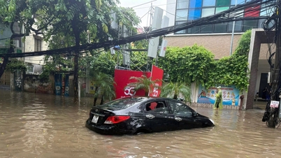
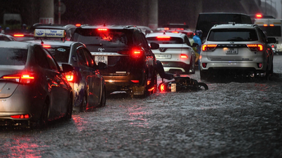
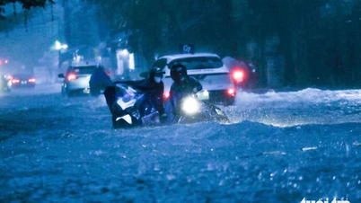
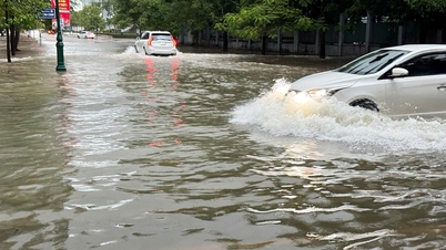
Heavy rain, flash floods and landslides
From the night of September 24 to September 26, the North, Thanh Hoa and Nghe An will have heavy to very heavy rain, with rainfall ranging from 150-300 mm, and in some places over 450 mm. Floods may occur on the Thao, Lo, Thai Binh , Hoang Long, Ma and Buoi rivers, with many places reaching alert levels 2-3. There is a risk of flash floods in small streams, landslides in mountainous areas and flooding in low-lying areas.
Due to the wide circulation of Storm No. 9 Ragasa, the Northern region is also likely to experience thunderstorms, tornadoes and strong gusts of wind both before and during the storm's landing. People need to closely monitor forecasts and proactively take preventive measures to limit risks.
Source: https://baonghean.vn/tin-bao-ragasa-luc-22h00-hom-nay-24-9-2025-bao-so-9-ragasa-sap-do-bo-sau-9-gio-toi-10307047.html


![[Photo] Prime Minister Pham Minh Chinh chaired a meeting of the Steering Committee on the arrangement of public service units under ministries, branches and localities.](https://vphoto.vietnam.vn/thumb/1200x675/vietnam/resource/IMAGE/2025/10/06/1759767137532_dsc-8743-jpg.webp)
![[Photo] Prime Minister Pham Minh Chinh chairs a meeting of the Government Standing Committee to remove obstacles for projects.](https://vphoto.vietnam.vn/thumb/1200x675/vietnam/resource/IMAGE/2025/10/06/1759768638313_dsc-9023-jpg.webp)


Comment (0)