
The National Center for Hydro-Meteorological Forecasting said that although storm No. 9 (storm Ragasa) has weakened and is no longer a super storm, it is still a strong and dangerous storm.
At 1:00 p.m. today, September 24, the storm center was located at about 21.5 degrees north latitude and 112.6 degrees east longitude, about 570 km east of Mong Cai ( Quang Ninh ). Near the storm center, the wind intensity was level 14, equivalent to wind speed from 150 - 166 km/h, gusting to level 17.

It is forecasted that tomorrow, September 25, storm No. 9 will make landfall in the northern provinces of our country. PHOTO: NCHMF
Forecast by 10am tomorrow, September 25, the center of storm No. 9 is at 21.5 degrees north latitude and 108.5 degrees east longitude, on the coastal area of Quang Ninh - Hai Phong . Near the center of the storm, strong wind intensity will decrease to level 10, gusting to level 12.
Due to the influence of storm No. 9, the northwestern sea of the East Sea has strong winds of level 10 - 12, near the center of the storm level 13 - 15, gusting over level 17. Waves over 10 m high, rough seas. The northeastern sea of the Gulf of Tonkin (including Bach Long Vy) has strong winds of level 6 - 7, gusting to level 9.
Forecast from tonight, September 24, in the northern Gulf of Tonkin (Bach Long Vy, Van Don, Co To, Cat Hai, Hon Dau), winds will gradually increase to level 7 - 8, waves 2 - 4 m high; near the storm center, level 9 - 11, gusts to level 13. Waves 3 - 5 m high, rough seas.
Quang Ninh coastal areas will have storm surges of 0.4 - 0.6 m. Boats anchored along the shore and aquaculture areas will be strongly affected by wind, big waves and rising sea levels.
Hanoi in the area of strong winds and heavy rains of storm number 9
The National Center for Hydro-Meteorological Forecasting warns that storm No. 9 (storm Ragasa) has a very wide circulation, people in the northern provinces should not be subjective, need to be on guard against thunderstorms and strong gusts of wind occurring before and during the storm's landfall.
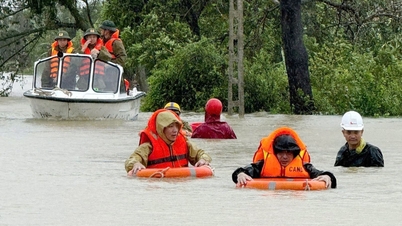
It is forecasted that around noon and afternoon of September 25, storm No. 9 will make landfall in the northern provinces, causing strong winds and heavy rain in many places.
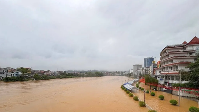
Starting tonight, September 24, the storm circulation will cause heavy to very heavy rain in the northern provinces, Thanh Hoa, Nghe An. Storm No. 9 will last until September 26, with forecasted rainfall of 100 - 250 mm, in some places over 400 mm; high risk of flooding in low-lying areas, flash floods on small rivers and streams, and landslides in mountainous areas.
Commenting on the impact of storm No. 9 on Hanoi, the Northern Hydrometeorological Station said that from tomorrow morning, September 25, the capital will have winds gradually increasing to level 4-5. Hanoi will have heavy rain from the morning of September 25 and lasting until the night of September 26.
The total rainfall forecast in the northern area of Hanoi is generally 70 - 130 mm, with some places over 200 mm. The central, western and southern areas of Hanoi will have heavier rain with the total rainfall being 80 - 150 mm, with some places over 250 mm.
Heavy rains caused by storm No. 9 in Hanoi threaten to overload the drainage system, causing localized flooding in residential and urban areas and traffic jams./.
According to Thanh Nien Newspaper
Source: https://thanhnien.vn/bao-so-9-di-vao-mien-bac-nhung-tinh-nao-se-gio-manh-mua-lon-185250924141216986.htm
Source: https://baolongan.vn/bao-so-9-di-vao-mien-bac-nhung-tinh-nao-se-gio-manh-mua-lon-a203100.html
![[Photo] General Secretary To Lam receives US Ambassador to Vietnam Marc Knapper](https://vphoto.vietnam.vn/thumb/1200x675/vietnam/resource/IMAGE/2025/9/29/c8fd0761aa184da7814aee57d87c49b3)
![[Photo] General Secretary To Lam, Secretary of the Central Military Commission attends the 12th Party Congress of the Army](https://vphoto.vietnam.vn/thumb/1200x675/vietnam/resource/IMAGE/2025/9/30/9b63aaa37ddb472ead84e3870a8ae825)
![[Photo] Solemn opening of the 12th Military Party Congress for the 2025-2030 term](https://vphoto.vietnam.vn/thumb/1200x675/vietnam/resource/IMAGE/2025/9/30/2cd383b3130d41a1a4b5ace0d5eb989d)
![[Photo] The 1st Congress of Phu Tho Provincial Party Committee, term 2025-2030](https://vphoto.vietnam.vn/thumb/1200x675/vietnam/resource/IMAGE/2025/9/30/1507da06216649bba8a1ce6251816820)


![[Photo] General Secretary To Lam attends the ceremony to celebrate the 80th anniversary of the post and telecommunications sector and the 66th anniversary of the science and technology sector.](https://vphoto.vietnam.vn/thumb/1200x675/vietnam/resource/IMAGE/2025/9/29/8e86b39b8fe44121a2b14a031f4cef46)


Comment (0)