

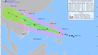
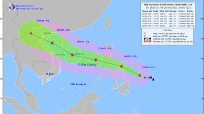
According to the National Center for Hydro-Meteorological Forecasting, at 10:00 a.m. on September 23, the center of the super storm was located at about 20.2 degrees North latitude; 117.7 degrees East longitude, in the northeastern sea area of the North East Sea. The strongest wind speed is level 16 - 17 (184-221 km/h), gusting above level 17. Moving in the West Northwest direction, speed about 20 km/h.
Storm forecast for the next 24 - 72 hours
At 10:00 on September 24, storm No. 9 moved in the West Northwest direction, 20-25 km/h and gradually weakened. Location was at about 21.7 North latitude - 113.4 East longitude; about 340 km east of Leizhou Peninsula (China).
At 10:00 a.m. on September 25, this storm moved westward at 20-25 km/h, continuing to weaken. Its location was at approximately 21.5 North latitude – 108.5 East longitude; in the sea area of Quang Ninh – Hai Phong .
At 10:00 p.m. on September 25, storm Ragasa moved west-southwest at about 25 km/h, weakening into a tropical depression.
Impact of storms on sea and land
Forecast under the impact of the storm, the North East Sea wind level 10-14, near the storm center level 15-17, gust > level 17; waves >10m high, rough sea.
From September 24, in the East of Bac Bo Gulf (Bach Long Vi), the wind will gradually increase to level 6-7, gusting to level 9. On the evening and night of September 24, the entire Bac Bo Gulf will have wind level 8-9, near the storm center level 10-12, gusting to level 14; waves 4-6m high, rough seas.
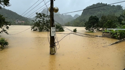
The coastal area of Quang Ninh - Hai Phong has storm surge of 0.5-1.0m, risk of landslides, embankments, damage to aquaculture and moored boats.
On land, from the morning of September 25, the wind along the Quang Ninh-Thanh Hoa coast gradually increased to level 6-7, then increased to level 8, near the storm center level 9-10, gusting to level 12. The Northeast region had wind level 6-7, gusting to level 8-9.
The storm caused heavy rain in the North, Thanh Hoa, Nghe An with heavy to very heavy rain, generally 100-250mm, locally >400mm on the night of September 24-26. Risk of urban flooding, flash floods on small rivers and streams, landslides.
Wide storm circulation, need to watch out for thunderstorms, tornadoes, strong gusts of wind before and during the storm.
Source: https://baohaiphong.vn/bao-so-9-giat-tren-cap-17-huong-vao-bac-bo-canh-bao-mua-dac-biet-lon-521557.html

![[Photo] General Secretary To Lam receives US Ambassador to Vietnam Marc Knapper](https://vphoto.vietnam.vn/thumb/1200x675/vietnam/resource/IMAGE/2025/9/29/c8fd0761aa184da7814aee57d87c49b3)
![[Photo] The 1st Congress of Phu Tho Provincial Party Committee, term 2025-2030](https://vphoto.vietnam.vn/thumb/1200x675/vietnam/resource/IMAGE/2025/9/30/1507da06216649bba8a1ce6251816820)
![[Photo] Solemn opening of the 12th Military Party Congress for the 2025-2030 term](https://vphoto.vietnam.vn/thumb/1200x675/vietnam/resource/IMAGE/2025/9/30/2cd383b3130d41a1a4b5ace0d5eb989d)
![[Photo] General Secretary To Lam, Secretary of the Central Military Commission attends the 12th Party Congress of the Army](https://vphoto.vietnam.vn/thumb/1200x675/vietnam/resource/IMAGE/2025/9/30/9b63aaa37ddb472ead84e3870a8ae825)


![[Photo] General Secretary To Lam attends the ceremony to celebrate the 80th anniversary of the post and telecommunications sector and the 66th anniversary of the science and technology sector.](https://vphoto.vietnam.vn/thumb/1200x675/vietnam/resource/IMAGE/2025/9/29/8e86b39b8fe44121a2b14a031f4cef46)


Comment (0)