

At 1 p.m. on September 25, the center of the storm was at about 21.6 degrees north latitude, 107.8 degrees east longitude on the mainland east of Quang Ninh province with the strongest wind at level 8-9, gusting to level 11. The storm moved west at a speed of about 20 km/h and gradually weakened into a tropical depression, then a low pressure area.
At 1:00 p.m. on September 26, the center of the low pressure was at about 21.4 degrees north latitude, 103.3 degrees east longitude on the mainland of the northwestern region of the North with the strongest wind speed below level 6.
Due to the influence of storm No. 9, from the night of September 24, the northern area of Bac Bo Gulf (Bach Long Vy, Van Don, Co To, Cat Hai, Hon Dau) will have winds gradually increasing to level 7-8, waves 2-4m high; near the center of the storm, winds will be level 9-11, gusts to level 13, waves 3-4.5m, and rough seas.

Coastal areas of Quang Ninh province have storm surges of 0.4-0.6 m. Boats anchored near the shore and aquaculture areas are strongly affected by wind, big waves and surges.
On land, from early morning on September 25, coastal areas from Quang Ninh to Hung Yen will see winds gradually increase to level 6-7, near the storm center level 8-9, gusting to level 11; deep inland in the Northeast region, winds will increase to level 5, in some places level 6, gusting to level 7-8.
From the night of September 24 to the end of the night of September 26, the Northern region, Thanh Hoa and Nghe An provinces will have heavy to very heavy rain with common rainfall of 150 - 300mm, in some places over 450mm; high risk of urban flooding.
From September 25 to 27, there is a possibility of a flood on rivers in the Northern region, Thanh Hoa and Nghe An provinces.
There is a risk of flash floods on small rivers and streams, and landslides in mountainous areas. Due to the wide storm circulation, it is necessary to be on guard against thunderstorms, tornadoes, and strong gusts of wind both before and during the storm.
* Also according to the forecast of the National Center for Hydro-Meteorological Forecasting, around the night of September 26, storm Bualoi will move into the eastern sea area of the central East Sea and become storm number 10 of 2025.
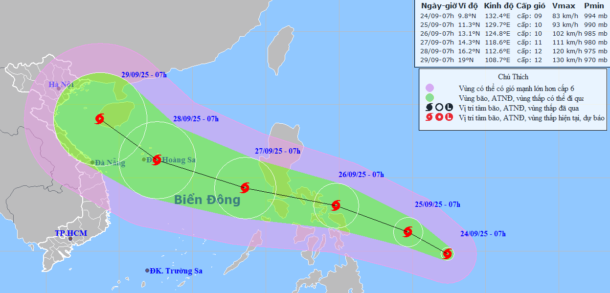
At 7:00 a.m. on September 27, the center of storm No. 10 will be at about 14.3 degrees north latitude, 118.6 degrees east longitude with the strongest wind at level 11, gusting to level 14 and likely to strengthen further.
The storm continues to move rapidly in a west-northwest direction at a speed of 20-25km/hour and is likely to strengthen.
Due to the influence of storm Bualoi, from the evening and night of September 26, the sea area east of the northern and central East Sea had strong winds of level 6-7, then increased to level 8-9, the area near the storm's center had winds of level 10-11, gusting to level 14, waves over 5-7m high, and rough seas.
Previously, on September 23, the Hydrometeorological Forecasting Department (Ministry of Agriculture and Environment) made an early assessment of storm No. 10 with the possibility of the storm moving into the Central region being the scenario with the highest probability, because during this period, according to climate laws, the storm will move into the Central region, but the possibility of strengthening to super storm level is not high.
Source: https://baodanang.vn/bao-so-9-se-suy-yeu-nhanh-bao-bualoi-se-anh-huong-trung-bo-3303546.html


![[Photo] Binh Trieu 1 Bridge has been completed, raised by 1.1m, and will open to traffic at the end of November.](https://vphoto.vietnam.vn/thumb/1200x675/vietnam/resource/IMAGE/2025/10/2/a6549e2a3b5848a1ba76a1ded6141fae)


Comment (0)