
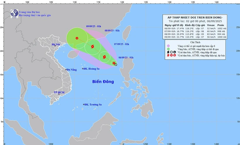
Forecast map of the tropical depression's trajectory and intensity at 2:00 a.m. on September 6.
The strongest wind near the center of the tropical depression is level 6 (39-49 km/h), gusting to level 8. Moving northwest at a speed of about 10 km/h.
Forecast of tropical depression/storm development in the next 24-48 hours, tropical depression/storm moving northwest, speed of about 10 km/hour and likely to strengthen into a storm.
The forecast location is about 18.7 degrees north latitude, 116.3 degrees east longitude, about 500 km east-northeast of the Paracel Islands. Wind force is level 8, gusting to level 10. The dangerous area is between latitude 16-20 degrees north; longitude 114.5-120 degrees east.
Disaster risk level: level 3, eastern sea area of the northern East Sea.
At 1:00 a.m. on September 8, the tropical depression/storm continued to move northwestward at a speed of about 15 km/h and intensified. The forecast location was at about 20.9 degrees north latitude - 113.8 degrees east longitude, in the northern sea area of the North East Sea. Strong winds at level 9, gusts at level 11. The dangerous area is between latitudes 17-22 degrees north; longitudes 112-118 degrees east. Disaster risk level: level 3, in the northern sea area of the North East Sea.
Storm warning for the next 48-72 hours, the storm moves west-northwest, about 15 km per hour.
In the northeastern part of the East Sea, there are strong winds of level 6, later increasing to level 7-8, gusting to level 10, waves 2-4m high, and rough seas. Ships operating in the danger zone are likely to be affected by storms, whirlwinds, strong winds, and large waves.
Source nhandan.vn
Source: https://baophutho.vn/tin-ap-thap-nhiet-doi-tren-bien-dong-co-kha-nang-manh-thanh-bao-239218.htm
![[Photo] General Secretary To Lam, Secretary of the Central Military Commission attends the 12th Party Congress of the Army](https://vphoto.vietnam.vn/thumb/1200x675/vietnam/resource/IMAGE/2025/9/30/9b63aaa37ddb472ead84e3870a8ae825)
![[Photo] President Luong Cuong receives President of the Cuban National Assembly Esteban Lazo Hernandez](https://vphoto.vietnam.vn/thumb/1200x675/vietnam/resource/IMAGE/2025/9/30/4d38932911c24f6ea1936252bd5427fa)
![[Photo] Panorama of the cable-stayed bridge, the final bottleneck of the Ben Luc-Long Thanh expressway](https://vphoto.vietnam.vn/thumb/1200x675/vietnam/resource/IMAGE/2025/9/30/391fdf21025541d6b2f092e49a17243f)
![[Photo] The 1st Congress of Phu Tho Provincial Party Committee, term 2025-2030](https://vphoto.vietnam.vn/thumb/1200x675/vietnam/resource/IMAGE/2025/9/30/1507da06216649bba8a1ce6251816820)
![[Photo] Solemn opening of the 12th Military Party Congress for the 2025-2030 term](https://vphoto.vietnam.vn/thumb/1200x675/vietnam/resource/IMAGE/2025/9/30/2cd383b3130d41a1a4b5ace0d5eb989d)


Comment (0)