
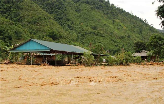
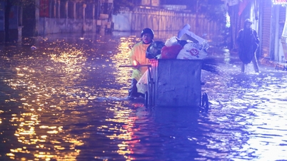
Beware of flash floods and landslides in 5 northern provinces
The National Center for Hydro-Meteorological Forecasting forecasts that from 10:30 a.m. to 3:30 p.m. on September 22, the provinces of Lai Chau, Dien Bien , Son La, Lao Cai and Tuyen Quang will continue to have rain with common accumulated rainfall as follows: Lao Cai from 10-30mm, some places over 50mm; Tuyen Quang from 20-40mm, some places over 70mm; Dien Bien, Son La and Lai Chau rain from 5-10mm, some places over 30mm.
Risk warning: flash floods on small rivers and streams, landslides on steep slopes in many communes/wards: Dao San, Khong Lao; Khoen On, Muong Kim, Sin Suoi Ho, Tua Sin Chai ( Lai Chau province);
Muong Pon; Chieng Sinh, Muong Mun, Nam Nen, Pa Ham, Pu Nhung, Sin Chai, Sinh Phinh, Tua Chua (Dien Bien province);
Chieng Lao, Muong Bu, Muong Gion, Muong Khieng, Muong La, Phieng Khoai, Ta Khoa, Yen Son ( Son La province);
Nghia Do; Ban Lien; Bac Ha, Ban Lau, Ban Xeo, Bao Nhai, Bat Xat, Coc Lau, Coc San, Gia Phu, Hop Thanh, Cam Duong, Sa Pa, Phong Hai, Ta Cu Ty, Ta Van, Trinh Tuong, Xuan Quang (Lao Cai province);
Ho Thau, Khuon Lung, Minh Son, Thong Nguyen, Thuong Nong; Bac Me, Cao Bo, Giap Trung, Hong Thai, Minh Ngoc, Nam Dich, Ngoc Duong, Ha Giang 1, Ha Giang 2, Phu Linh, Quang Binh, Quang Nguyen, Thuan Hoa, Thuong Son, Tien Nguyen, Tung Ba, Viet Lam, Yen Hoa, Yen Thanh (Tuyen Quang province).
Level of natural disaster risk due to flash floods, landslides, land subsidence due to heavy rain or level 1 flow.
Flash floods and landslides can have very negative impacts on the environment, threaten people's lives; cause local traffic congestion, affect the movement of vehicles; destroy civil and economic works, causing damage to production and socio-economic activities.
The hydrometeorological agency recommends that local authorities pay attention to reviewing bottlenecks and vulnerable locations in the area to have prevention and response measures.
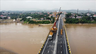
From 00:00 to 9:00 on September 22, the provinces of Lai Chau, Dien Bien, Son La, Lao Cai and Tuyen Quang had moderate rain, heavy rain, and very heavy rain in some places such as: Dao San (Lai Chau) 109.2mm; Nam Xe (Lai Chau) 72mm; Muong Pon (Dien Bien) 100mm; Ta Ma (Dien Bien) 73.6mm; Nam Gion (Son La) 105.2mm; Muong Khieng (Son La) 89mm; Tan Tien (Lao Cai) 165.2mm; Ban Lien (Lao Cai) 138mm; Xuan Minh (Tuyen Quang) 176.2mm; Na Chi (Tuyen Quang) 159.8mm;...
Soil moisture models show that some areas in the above provinces are close to saturation (over 85%) or have reached saturation.
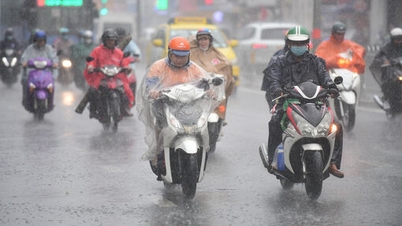
Heavy rain in many areas
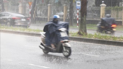
According to the National Center for Hydro-Meteorological Forecasting, on the day and night of September 22, the Northern region and Thanh Hoa will have scattered showers and thunderstorms with rainfall of 10-30mm, locally heavy to very heavy rain over 100mm. The Central Highlands and the South will have rain, moderate rain and scattered thunderstorms with rainfall of 20-40mm, locally heavy to very heavy rain over 100mm.
Warning of risk of heavy rain over 100mm in 3 hours.
On the afternoon and evening of September 22, the South Central Coast region will have scattered showers and thunderstorms with rainfall from 15-30mm, with some places having heavy rain over 80mm. Warning of danger
heavy rainfall of over 80mm in 3 hours
"Thunderstorms in the areas are likely to cause tornadoes, lightning, hail and strong gusts of wind. Localized heavy rains can cause flash floods on small rivers and streams, landslides on steep slopes and flooding in low-lying areas," Deputy Head of the Department Le Thi Loan noted.
On the night of September 21 and the morning of September 22, the mountainous areas and the Northern Delta, the Central Highlands and the Southeast region will have showers and thunderstorms, with some places having heavy to very heavy rain. The rainfall from 7:00 p.m. on September 21 to 8:00 a.m. on September 22 was over 90mm in some places such as: Tan Tien station (Lao Cai) 161.2mm, Xuan Minh station (Tuyen Quang) 157.8mm, Muong Bang station (Dien Bien) 111.6mm, Tra Giang station (Thai Binh) 108mm, Nam Gion station (Son La) 105.2mm, Thanh An station (Ho Chi Minh City) 97.4mm,...
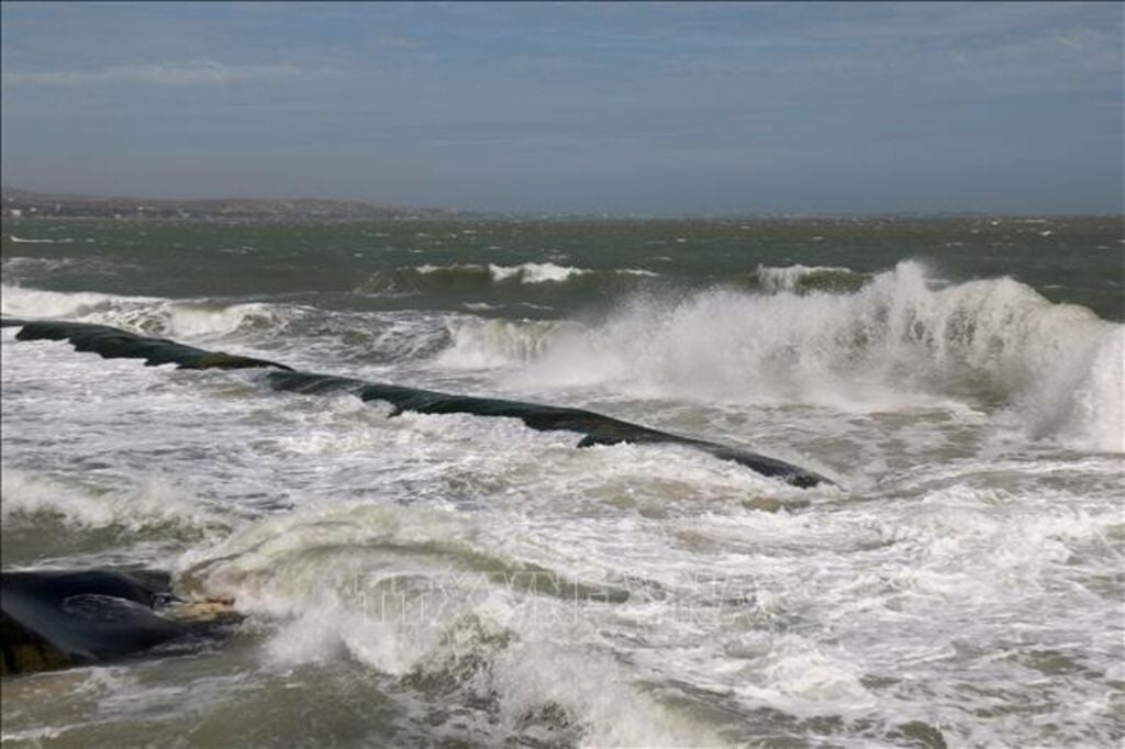
Many sea areas have strong winds and high waves.
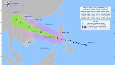
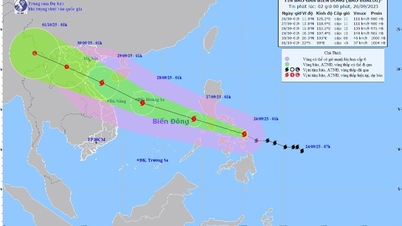
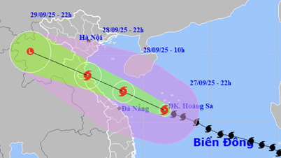
The National Center for Hydro-Meteorological Forecasting said that currently, the northern Gulf of Tonkin, the sea area from Gia Lai to Ca Mau, between the East Sea and the northern part of the southern East Sea (including the sea area north of Truong Sa special zone) will have scattered showers and thunderstorms. The eastern part of the northern East Sea area will have storms.
Forecast, on the day and night of September 22, the sea area east of the central East Sea will have winds gradually increasing to level 6-7, gusting to level 9, rough seas, waves 3-5m high.
The sea area from Khanh Hoa to Ho Chi Minh City has wind level 5, sometimes level 6, gusting to level 7-8; from night the wind gradually increases to level 6, gusting to level 7-8, rough sea, waves 2-3m high.
In the South China Sea (including Truong Sa special zone), the wind is strong at level 6, sometimes at night it is level 7, gusting to level 8-9, rough seas, waves 2-4m high.
In addition, on the day and night of September 22, the sea area east of the North East Sea will have storms. The central East Sea area, the sea area north of the South East Sea area (including the sea area north of Truong Sa special zone), the North Gulf of Tonkin, the sea area from South Quang Tri to Ca Mau, Ca Mau to An Giang will have scattered showers and thunderstorms, with the possibility of tornadoes, strong gusts of wind of level 6-7 and waves over 2m high.
Warning, on the day and night of September 23, the sea area south of the North East Sea (including Hoang Sa special zone), the central East Sea area has strong southwest to south wind level 6-7, sometimes level 8, gusting to level 9-10; waves 3-5m high; rough seas.
The sea area from Khanh Hoa to Ho Chi Minh City and the South East Sea area (including Truong Sa special zone) has strong southwest wind level 6, sometimes level 7, gusting to level 9; waves 3-5m high; rough seas.
Level 2 risk of natural disasters due to strong winds at sea.
All vessels operating in the above areas are at high risk of being affected by cyclones, strong winds and large waves.
Source: https://baotintuc.vn/van-de-quan-tam/canh-bao-mua-lon-cuc-bo-o-5-tinh-phia-bacde-phong-lu-quet-sat-lo-dat-20250922110614484.htm


![[Photo] Soldiers guard the fire and protect the forest](https://vphoto.vietnam.vn/thumb/1200x675/vietnam/resource/IMAGE/2025/9/27/7cab6a2afcf543558a98f4d87e9aaf95)


![[Photo] Prime Minister Pham Minh Chinh attends the 1st Hai Phong City Party Congress](https://vphoto.vietnam.vn/thumb/1200x675/vietnam/resource/IMAGE/2025/9/27/676f179ddf8c4b4c84b4cfc8f28a9550)


Comment (0)